


<< Our Photo Pages >> Twyford stone circle - Stone Circle in England in Hampshire
Submitted by JimChampion on Monday, 05 June 2006 Page Views: 20949
Neolithic and Bronze AgeSite Name: Twyford stone circleCountry: England County: Hampshire Type: Stone Circle
Nearest Town: Winchester Nearest Village: Twyford
Map Ref: SU481250
Latitude: 51.022367N Longitude: 1.31558W
Condition:
| 5 | Perfect |
| 4 | Almost Perfect |
| 3 | Reasonable but with some damage |
| 2 | Ruined but still recognisable as an ancient site |
| 1 | Pretty much destroyed, possibly visible as crop marks |
| 0 | No data. |
| -1 | Completely destroyed |
| 5 | Superb |
| 4 | Good |
| 3 | Ordinary |
| 2 | Not Good |
| 1 | Awful |
| 0 | No data. |
| 5 | Can be driven to, probably with disabled access |
| 4 | Short walk on a footpath |
| 3 | Requiring a bit more of a walk |
| 2 | A long walk |
| 1 | In the middle of nowhere, a nightmare to find |
| 0 | No data. |
| 5 | co-ordinates taken by GPS or official recorded co-ordinates |
| 4 | co-ordinates scaled from a detailed map |
| 3 | co-ordinates scaled from a bad map |
| 2 | co-ordinates of the nearest village |
| 1 | co-ordinates of the nearest town |
| 0 | no data |
Internal Links:
External Links:
I have visited· I would like to visit
JimChampion has visited here
")
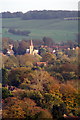
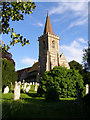
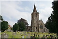
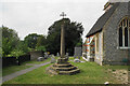
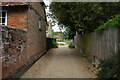
To the west of the churchyard is Berry Bridge over the River Itchen. On the left of the lane as you approach the bridge (grid reference SU48002511) are two recumbent sarsen stones "connected with village legend".[source].
The Twyford Parish Council website expands a bit further on the "local folklore" ... the twelve stones originally stood as an upright circle on a mound near the site of the church. A Charter granted in the year 972 AD, in the reign of King Edgar, refers to an 'Egsanmor' (slaughter stone) at Twyford. It is from bits of evidence such as these that the legend evolved of a Druidic religious site having existed in the village in pre-Roman times - perfectly plausible, given the proximity of Bronze Age (ca 1500 BC) and Iron Age (ca 1 AD) settlements on the hill later named after St Catherine and on Twyford Down.
If you know anything more about these local legends, or if you have visited this site and have any other relevant comments then please leave them using the form below.
Access The church is to the west of the B3335 through Twyford, down Church Lane. There is room to park next to the churchyard. It is also accessible from the footpaths along the Itchen valley to the south of Winchester.
You may be viewing yesterday's version of this page. To see the most up to date information please register for a free account.
")
")
")
Do not use the above information on other web sites or publications without permission of the contributor.
Nearby Images from Geograph Britain and Ireland:
©2006(licence)
©2006(licence)
©2021(licence)
©2021(licence)
©2021(licence)
The above images may not be of the site on this page, they are loaded from Geograph.
Please Submit an Image of this site or go out and take one for us!
Click here to see more info for this site
Nearby sites
Key: Red: member's photo, Blue: 3rd party photo, Yellow: other image, Green: no photo - please go there and take one, Grey: site destroyed
Download sites to:
KML (Google Earth)
GPX (GPS waypoints)
CSV (Garmin/Navman)
CSV (Excel)
To unlock full downloads you need to sign up as a Contributory Member. Otherwise downloads are limited to 50 sites.
Turn off the page maps and other distractions
Nearby sites listing. In the following links * = Image available
2.1km NW 321° Compton Down Barrows* Round Barrow(s) (SU46762660)
2.7km N 7° St Catherine's Hill (Hampshire)* Hillfort (SU48422766)
2.7km NNE 19° Twyford Down monument* Modern Stone Circle etc (SU48962757)
2.7km N 9° Mizmaze* Turf Maze (SU48482769)
2.8km NNE 22° The Dongas* Ancient Trackway (SU491276)
3.2km NW 309° Texas Barrows* Round Barrow(s) (SU4558926993)
3.8km E 86° Morestead Warren* Long Barrow (SU519253)
4.2km N 2° Winchester Cathedral Wells* Holy Well or Sacred Spring (SU482292)
4.4km N 0° Winchester City Museum* Museum (SU4809729407)
4.5km N 355° Hampshire Jubilee Sculpture* Modern Stone Circle etc (SU477295)
4.7km NNE 24° Magdalen Hill Down* Barrow Cemetery (SU49992933)
4.7km N 353° Oram's Arbour Hillfort (SU475297)
5.1km NE 53° Telegraph Hill Bowl Barrow* Round Barrow(s) (SU521281)
5.2km ENE 59° Cheesefoot Head Barrows* Barrow Cemetery (SU52572777)
5.3km E 97° Longwood Barrow Long Barrow (SU534244)
6.1km WNW 284° Merdon Castle* Hillfort (SU421264)
7.1km NW 309° West Wood Bowl Barrow* Round Barrow(s) (SU42522949)
7.3km NNW 343° Flowerdown Barrows* Barrow Cemetery (SU459320)
8.0km WNW 303° Robin Hood's Barrow (Winchester)* Round Barrow(s) (SU41322927)
8.7km WNW 298° Farley Mount* Round Barrow(s) (SU403290)
9.5km WNW 296° Withering Corner Barrow Cemetery (SU395291)
10.5km SW 221° Chilworth Ring* Hillfort (SU413170)
11.1km SW 223° Castle Hill (Southampton)* Misc. Earthwork (SU40571688)
11.1km N 356° South Wonston* Barrow Cemetery (SU4723736091)
11.5km ENE 76° Hinton Ampner tumuli* Round Barrow(s) (SU593278)
View more nearby sites and additional images


 We would like to know more about this location. Please feel free to add a brief description and any relevant information in your own language.
 Wir möchten mehr über diese Stätte erfahren. Bitte zögern Sie nicht, eine kurze Beschreibung und relevante Informationen in Deutsch hinzuzufügen.
 Nous aimerions en savoir encore un peu sur les lieux. S'il vous plaît n'hesitez pas à ajouter une courte description et tous les renseignements pertinents dans votre propre langue.
 Quisieramos informarnos un poco más de las lugares. No dude en añadir una breve descripción y otros datos relevantes en su propio idioma.