


<< Our Photo Pages >> Skellister - Standing Stones in Scotland in Shetland
Submitted by jeffrep on Thursday, 15 February 2001 Page Views: 9752
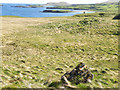
Neolithic and Bronze AgeSite Name: Skellister Alternative Name: Auld WifeCountry: Scotland County: Shetland Type: Standing Stones
Map Ref: HU463552 Landranger Map Number: 3
Latitude: 60.278360N Longitude: 1.1647W
Condition:
| 5 | Perfect |
| 4 | Almost Perfect |
| 3 | Reasonable but with some damage |
| 2 | Ruined but still recognisable as an ancient site |
| 1 | Pretty much destroyed, possibly visible as crop marks |
| 0 | No data. |
| -1 | Completely destroyed |
| 5 | Superb |
| 4 | Good |
| 3 | Ordinary |
| 2 | Not Good |
| 1 | Awful |
| 0 | No data. |
| 5 | Can be driven to, probably with disabled access |
| 4 | Short walk on a footpath |
| 3 | Requiring a bit more of a walk |
| 2 | A long walk |
| 1 | In the middle of nowhere, a nightmare to find |
| 0 | No data. |
| 5 | co-ordinates taken by GPS or official recorded co-ordinates |
| 4 | co-ordinates scaled from a detailed map |
| 3 | co-ordinates scaled from a bad map |
| 2 | co-ordinates of the nearest village |
| 1 | co-ordinates of the nearest town |
| 0 | no data |
Internal Links:
External Links:
I have visited· I would like to visit
43559959 would like to visit
jeffrep has visited here
")
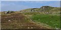
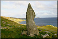
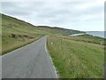
Locally it is also known as the Auld Wife (Old Wife), because in silhouette it resembles a stooped, albeit tall, old woman. The Skellister Standing Stone is located near the village of Skellister on the Hill of Skellister off the B9075, a minor road in the South Nesting area of the Central Mainland off the A970 main road.
You may be viewing yesterday's version of this page. To see the most up to date information please register for a free account.
")
")
")
Do not use the above information on other web sites or publications without permission of the contributor.
Nearby Images from Geograph Britain and Ireland:
©2008(licence)
©2007(licence)
©2007(licence)
©2022(licence)
©2009(licence)
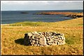
The above images may not be of the site on this page, they are loaded from Geograph.
Please Submit an Image of this site or go out and take one for us!
Click here to see more info for this site
Nearby sites
Key: Red: member's photo, Blue: 3rd party photo, Yellow: other image, Green: no photo - please go there and take one, Grey: site destroyed
Download sites to:
KML (Google Earth)
GPX (GPS waypoints)
CSV (Garmin/Navman)
CSV (Excel)
To unlock full downloads you need to sign up as a Contributory Member. Otherwise downloads are limited to 50 sites.
![]()
Turn off the page maps and other distractions
Nearby sites listing. In the following links * = Image available
4.1km S 171° Gletness Broch or Nuraghe (HU470512)
4.3km NE 46° Loch of Kirkabister Burnt Mound Artificial Mound (HU49355821)
4.7km NE 36° Loch of Stavaness Broch or Nuraghe (HU490590)
7.8km SW 231° Loch Of Strom* Stone Circle (HU4034450203)
9.8km N 359° Lunnasting Standing Stone* Standing Stone (Menhir) (HU4665)
10.2km WNW 285° East Burra Firth Chambered Cairn* Chambered Cairn (HU364577)
10.4km SW 214° Wormadale Hill* Standing Stone (Menhir) (HU4053046490)
10.6km SSW 213° Westings Hill* Stone Circle (HU4068346194)
10.8km WNW 286° East Burra Firth Broch* Broch or Nuraghe (HU358580)
12.6km SW 217° Easthouse* Standing Stones (HU388450)
12.7km SSE 168° Stane o'Cruester* Standing Stone (Menhir) (HU490428)
13.0km S 173° Burnt Mound of Cruester* Ancient Village or Settlement (HU4816142310)
13.1km WSW 249° Semblister Broch or Nuraghe (HU341503)
13.8km W 273° Gravlaba* Standing Stones (HU325558)
13.9km WSW 252° Semblister Stone Circle* Stone Circle (HU3307450733)
13.9km S 176° Shetland Museum* Museum (HU474413)
14.1km N 10° Chapel Knowe Broch or Nuraghe (HU48556910)
14.1km SSW 202° Tingwall stone* Standing Stone (Menhir) (HU4123742029)
14.1km SSE 157° Cullingsburgh* Broch or Nuraghe (HU521423)
14.1km SSE 157° Bressay Pictish Cross Slab* Class III Pictish Cross Slab (HU5210042300)
14.4km S 180° Clickhimin* Broch or Nuraghe (HU46434081)
15.1km SSW 206° Loch of Houlland Ancient Village or Settlement (HU39754161)
15.6km SSE 156° Noss Sound Broch* Broch or Nuraghe (HU528410)
16.6km SSE 162° Wadbister Souterrain* Souterrain (Fogou, Earth House) (HU5163139487)
16.7km NW 318° Busta Brae* Standing Stones (HU34886739)
View more nearby sites and additional images


 We would like to know more about this location. Please feel free to add a brief description and any relevant information in your own language.
 Wir möchten mehr über diese Stätte erfahren. Bitte zögern Sie nicht, eine kurze Beschreibung und relevante Informationen in Deutsch hinzuzufügen.
 Nous aimerions en savoir encore un peu sur les lieux. S'il vous plaît n'hesitez pas à ajouter une courte description et tous les renseignements pertinents dans votre propre langue.
 Quisieramos informarnos un poco más de las lugares. No dude en añadir una breve descripción y otros datos relevantes en su propio idioma.