


<< Our Photo Pages >> Scholes Wood - Hillfort in England in Yorkshire (South)
Submitted by vicky on Monday, 14 October 2002 Page Views: 12996
Iron Age and Later PrehistorySite Name: Scholes WoodCountry: England County: Yorkshire (South) Type: Hillfort
Map Ref: SK395952 Landranger Map Number: 110
Latitude: 53.452085N Longitude: 1.406667W
Condition:
| 5 | Perfect |
| 4 | Almost Perfect |
| 3 | Reasonable but with some damage |
| 2 | Ruined but still recognisable as an ancient site |
| 1 | Pretty much destroyed, possibly visible as crop marks |
| 0 | No data. |
| -1 | Completely destroyed |
| 5 | Superb |
| 4 | Good |
| 3 | Ordinary |
| 2 | Not Good |
| 1 | Awful |
| 0 | No data. |
| 5 | Can be driven to, probably with disabled access |
| 4 | Short walk on a footpath |
| 3 | Requiring a bit more of a walk |
| 2 | A long walk |
| 1 | In the middle of nowhere, a nightmare to find |
| 0 | No data. |
| 5 | co-ordinates taken by GPS or official recorded co-ordinates |
| 4 | co-ordinates scaled from a detailed map |
| 3 | co-ordinates scaled from a bad map |
| 2 | co-ordinates of the nearest village |
| 1 | co-ordinates of the nearest town |
| 0 | no data |
Internal Links:
External Links:
I have visited· I would like to visit
dagadd visited on 1st Feb 2015 - their rating: Cond: 3 Amb: 4 Access: 4 Plenty of litter around, which I cleared.
Plenty of trees growing from the ramparts.
No information board (two local dog-walkers had no idea what it was), although one would probably be destroyed.
MartinRS have visited here
")
Have you visited this site? Please add a comment below.
You may be viewing yesterday's version of this page. To see the most up to date information please register for a free account.
")
Do not use the above information on other web sites or publications without permission of the contributor.
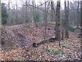
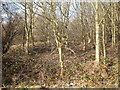
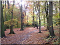
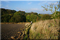
Nearby Images from Geograph Britain and Ireland:
©2010(licence)
©2010(licence)
©2007(licence)
©2014(licence)
©2014(licence)
The above images may not be of the site on this page, they are loaded from Geograph.
Please Submit an Image of this site or go out and take one for us!
Click here to see more info for this site
Nearby sites
Key: Red: member's photo, Blue: 3rd party photo, Yellow: other image, Green: no photo - please go there and take one, Grey: site destroyed
Download sites to:
KML (Google Earth)
GPX (GPS waypoints)
CSV (Garmin/Navman)
CSV (Excel)
To unlock full downloads you need to sign up as a Contributory Member. Otherwise downloads are limited to 50 sites.
Turn off the page maps and other distractions
Nearby sites listing. In the following links * = Image available
1.3km NE 52° Roman Ridge (Rotherham)* Misc. Earthwork (SK40499598)
2.6km WNW 288° St. Helen's Well (Thorpe Hesley) Holy Well or Sacred Spring (SK370960)
4.3km WSW 256° Ecclesfield* Ancient Cross (SK353941)
4.5km SSW 202° Wincobank* Vitrified Fort (SK378910)
6.2km WNW 282° Robin Hood Well (Yorkshire South)* Holy Well or Sacred Spring (SK334964)
6.7km SSW 195° Darnall Common* Modern Stone Circle etc (SK378887)
8.5km W 276° Burnt Hill Plantation* Rock Art (SK310960)
9.0km W 276° Dragon Well (Wharncliffe) Holy Well or Sacred Spring (SK305961)
9.5km WSW 241° Wadsley Common* Stone Circle (SK312906)
9.7km SW 216° Weston Park Museum* Museum (SK3389487292)
10.8km WNW 286° Deepcar Mesolithic Settlement* Ancient Village or Settlement (SK291981)
11.2km NW 315° Stainborough Castle* Hillfort (SE315030)
11.2km NNW 331° Worsborough Common Hillfort (SE340050)
11.3km W 279° Dragon's Well (Bolsterstone) Holy Well or Sacred Spring (SK28279697)
11.7km S 174° Birley Spa Holy Well or Sacred Spring (SK40908361)
12.2km ENE 73° St Francis's Well (Conisborough) Holy Well or Sacred Spring (SK51179881)
12.2km ENE 73° St Peter's Minster (Conisbrough)* Sculptured Stone (SK512988)
12.8km ENE 70° Cadeby Henge Henge (SK515997)
13.0km WSW 259° St Nicholas (Bradfield) Ancient Cross (SK26729254)
13.5km W 266° Handsome Cross Ancient Cross (SK26019412)
13.9km SSW 210° Ecclesall Woods* Rock Art (SK326831)
14.8km W 269° Bar Dyke (Yorkshire)* Misc. Earthwork (SK247947)
14.8km ENE 63° Scabba Wood Rock Shelter Cave or Rock Shelter (SE527020)
15.0km W 268° Bar Dyke Ring* Ring Cairn (SK245946)
15.0km W 268° Apronful of Stones (Bradfield) Cairn (SK2448094582)
View more nearby sites and additional images


 We would like to know more about this location. Please feel free to add a brief description and any relevant information in your own language.
 Wir möchten mehr über diese Stätte erfahren. Bitte zögern Sie nicht, eine kurze Beschreibung und relevante Informationen in Deutsch hinzuzufügen.
 Nous aimerions en savoir encore un peu sur les lieux. S'il vous plaît n'hesitez pas à ajouter une courte description et tous les renseignements pertinents dans votre propre langue.
 Quisieramos informarnos un poco más de las lugares. No dude en añadir una breve descripción y otros datos relevantes en su propio idioma.