

<< Our Photo Pages >> West Burra, Mid Field - Standing Stone (Menhir) in Scotland in Shetland
Submitted by SandyG on Monday, 10 February 2020 Page Views: 701
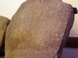
Neolithic and Bronze AgeSite Name: West Burra, Mid FieldCountry: Scotland County: Shetland Type: Standing Stone (Menhir)
Map Ref: HU37003259
Latitude: 60.076314N Longitude: 1.336933W
Condition:
| 5 | Perfect |
| 4 | Almost Perfect |
| 3 | Reasonable but with some damage |
| 2 | Ruined but still recognisable as an ancient site |
| 1 | Pretty much destroyed, possibly visible as crop marks |
| 0 | No data. |
| -1 | Completely destroyed |
| 5 | Superb |
| 4 | Good |
| 3 | Ordinary |
| 2 | Not Good |
| 1 | Awful |
| 0 | No data. |
| 5 | Can be driven to, probably with disabled access |
| 4 | Short walk on a footpath |
| 3 | Requiring a bit more of a walk |
| 2 | A long walk |
| 1 | In the middle of nowhere, a nightmare to find |
| 0 | No data. |
| 5 | co-ordinates taken by GPS or official recorded co-ordinates |
| 4 | co-ordinates scaled from a detailed map |
| 3 | co-ordinates scaled from a bad map |
| 2 | co-ordinates of the nearest village |
| 1 | co-ordinates of the nearest town |
| 0 | no data |
Internal Links:
External Links:
")
Canmore
You may be viewing yesterday's version of this page. To see the most up to date information please register for a free account.
")
")
Do not use the above information on other web sites or publications without permission of the contributor.
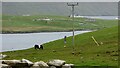
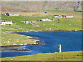
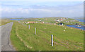
Nearby Images from Geograph Britain and Ireland:
©2021(licence)
©2009(licence)
©2017(licence)
©2016(licence)
©2019(licence)
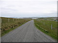
The above images may not be of the site on this page, they are loaded from Geograph.
Please Submit an Image of this site or go out and take one for us!
Click here to see more info for this site
Nearby sites
Key: Red: member's photo, Blue: 3rd party photo, Yellow: other image, Green: no photo - please go there and take one, Grey: site destroyed
Download sites to:
KML (Google Earth)
GPX (GPS waypoints)
CSV (Garmin/Navman)
CSV (Excel)
To unlock full downloads you need to sign up as a Contributory Member. Otherwise downloads are limited to 50 sites.
Turn off the page maps and other distractions
Nearby sites listing. In the following links * = Image available
9m E 84° West Burra, Mid Field Standing Stone (Menhir) (HU3700932591)
839m ENE 74° East Burra, Yaa Field Standing Stone (Menhir) (HU3780532835)
1.1km S 191° Papil Pictish Stone Cross Slab* Class III Pictish Cross Slab (HU368315)
2.1km NNE 25° Gulver Knowe burnt mound* Artificial Mound (HU37893455)
6.8km ESE 119° Everglades North Broch or Nuraghe (HU43002930)
7.6km NE 55° Loch of Brindister* Stone Fort or Dun (HU43263701)
7.8km ESE 115° Clodie Knowe* Broch or Nuraghe (HU441294)
7.9km SE 128° Broch of Mail* Broch or Nuraghe (HU43252779)
8.3km ENE 66° Broch of Burland* Broch or Nuraghe (HU44553607)
9.4km NNE 18° Loch of Houlland Ancient Village or Settlement (HU39754161)
10.3km NNE 25° Tingwall stone* Standing Stone (Menhir) (HU4123742029)
11.7km S 181° St Ninian's Isle* Ancient Village or Settlement (HU36852090)
12.1km SE 141° Burraland* Broch or Nuraghe (HU44682319)
12.2km SSE 161° Knowe Of Willil Burnt Mound* Artificial Mound (HU41122105)
12.5km NE 49° Clickhimin* Broch or Nuraghe (HU46434081)
12.5km SE 137° Mousa Broch* Broch or Nuraghe (HU457236)
12.5km N 9° Easthouse* Standing Stones (HU388450)
12.6km SE 135° Mousa Burnt Mounds* Artificial Mound (HU45942370)
12.6km NW 325° Hoddans Chambered Cairn (HU29684293)
12.8km NNW 328° Yahaarwell* Standing Stone (Menhir) (HU30054332)
12.8km NW 322° Ward of Silwick Chambered Cairn (HU29004267)
13.5km NE 51° Shetland Museum* Museum (HU474413)
13.6km SSE 161° Levenwick Broch* Broch or Nuraghe (HU415197)
13.9km S 173° Ward Of Scousburgh* Cairn (HU38791880)
14.1km NNE 16° Westings Hill* Stone Circle (HU4068346194)
View more nearby sites and additional images


 We would like to know more about this location. Please feel free to add a brief description and any relevant information in your own language.
 Wir möchten mehr über diese Stätte erfahren. Bitte zögern Sie nicht, eine kurze Beschreibung und relevante Informationen in Deutsch hinzuzufügen.
 Nous aimerions en savoir encore un peu sur les lieux. S'il vous plaît n'hesitez pas à ajouter une courte description et tous les renseignements pertinents dans votre propre langue.
 Quisieramos informarnos un poco más de las lugares. No dude en añadir una breve descripción y otros datos relevantes en su propio idioma.