


<< Our Photo Pages >> Stanydale Neolithic house - Ancient Village or Settlement in Scotland in Shetland
Submitted by SandyG on Sunday, 09 February 2020 Page Views: 625
Neolithic and Bronze AgeSite Name: Stanydale Neolithic houseCountry: Scotland
NOTE: This site is 1.9 km away from the location you searched for.
County: Shetland Type: Ancient Village or Settlement
Map Ref: HU28785019
Latitude: 60.234992N Longitude: 1.482156W
Condition:
| 5 | Perfect |
| 4 | Almost Perfect |
| 3 | Reasonable but with some damage |
| 2 | Ruined but still recognisable as an ancient site |
| 1 | Pretty much destroyed, possibly visible as crop marks |
| 0 | No data. |
| -1 | Completely destroyed |
| 5 | Superb |
| 4 | Good |
| 3 | Ordinary |
| 2 | Not Good |
| 1 | Awful |
| 0 | No data. |
| 5 | Can be driven to, probably with disabled access |
| 4 | Short walk on a footpath |
| 3 | Requiring a bit more of a walk |
| 2 | A long walk |
| 1 | In the middle of nowhere, a nightmare to find |
| 0 | No data. |
| 5 | co-ordinates taken by GPS or official recorded co-ordinates |
| 4 | co-ordinates scaled from a detailed map |
| 3 | co-ordinates scaled from a bad map |
| 2 | co-ordinates of the nearest village |
| 1 | co-ordinates of the nearest town |
| 0 | no data |
Internal Links:
External Links:
")
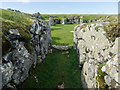
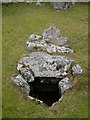
A Neolithic house excavated by Charles Calder in 1950. The building has a porch in front of the entrance and there is a small enclosure attached to the southern side. This house is situated next to the path that leads from the highway to "Staneydale Temple". The excavation report states that this house is at HU 288503 but this would seem to be an error. The excavation revealed an oval-shaped room, an inner chamber, two recesses, a hearth, bench and paving within the entrance. This house still survives very well as an earthwork. PSAS Excavation Report
You may be viewing yesterday's version of this page. To see the most up to date information please register for a free account.
")
")
")
Do not use the above information on other web sites or publications without permission of the contributor.
Nearby Images from Geograph Britain and Ireland:
©2014(licence)
©2014(licence)
©2021(licence)
©2008(licence)
©2005(licence)
The above images may not be of the site on this page, they are loaded from Geograph.
Please Submit an Image of this site or go out and take one for us!
Click here to see more info for this site
Nearby sites
Key: Red: member's photo, Blue: 3rd party photo, Yellow: other image, Green: no photo - please go there and take one, Grey: site destroyed
Download sites to:
KML (Google Earth)
GPX (GPS waypoints)
CSV (Garmin/Navman)
CSV (Excel)
To unlock full downloads you need to sign up as a Contributory Member. Otherwise downloads are limited to 50 sites.
Turn off the page maps and other distractions
Nearby sites listing. In the following links * = Image available
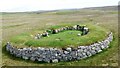
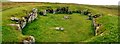
251m WNW 282° Stanydale* Stone Circle (HU2853450242)
260m W 275° Stanydale standing stones* Standing Stones (HU28525021)
3.0km WNW 282° Gallow Hill chambered cairn* Chambered Cairn (HU2581850821)
3.1km W 279° Gallow Hill Cairn* Cairn (HU25715067)
3.5km WNW 295° Scord of Brouster* Ancient Village or Settlement (HU25605165)
4.2km WNW 289° Cattapund Knowe cairn* Cairn (HU2480851533)
4.3km E 83° Semblister Stone Circle* Stone Circle (HU3307450733)
4.4km WNW 286° Hansie's Crooie Field System* Ancient Village or Settlement (HU24545133)
4.5km WNW 287° Hansies Crooie* Chambered Cairn (HU24485147)
4.5km S 175° Giant's Grave (Hestinsetter Hill)* Chambered Cairn (HU2919945702)
4.6km W 266° Kirkidale Standing Stone* Standing Stone (Menhir) (HU24214984)
4.9km WNW 295° Loch Of Flatpunds* Chambered Cairn (HU24305219)
4.9km WNW 298° Trolligarts 1* Chambered Cairn (HU24415243)
5.0km WNW 298° Trolligarts 2* Chambered Cairn (HU24275249)
5.3km E 89° Semblister Broch or Nuraghe (HU341503)
6.4km SSW 213° Culswick Broch* Broch or Nuraghe (HU253448)
6.5km NW 305° Burga Water Dun* Stone Fort or Dun (HU234539)
6.7km NE 34° Gravlaba* Standing Stones (HU325558)
7.0km NW 304° Burga Water cairn* Cairn (HU22975407)
7.0km S 170° Yahaarwell* Standing Stone (Menhir) (HU30054332)
7.0km N 357° Brindister Voe Broch* Broch or Nuraghe (HU284572)
7.3km S 173° Hoddans Chambered Cairn (HU29684293)
7.4km W 260° Stanesland standing stone* Standing Stone (Menhir) (HU21524889)
7.5km S 179° Ward of Silwick Chambered Cairn (HU29004267)
7.6km NNW 338° Giant's Stone (West Burrafirth)* Standing Stone (Menhir) (HU2583157157)
View more nearby sites and additional images


 We would like to know more about this location. Please feel free to add a brief description and any relevant information in your own language.
 Wir möchten mehr über diese Stätte erfahren. Bitte zögern Sie nicht, eine kurze Beschreibung und relevante Informationen in Deutsch hinzuzufügen.
 Nous aimerions en savoir encore un peu sur les lieux. S'il vous plaît n'hesitez pas à ajouter une courte description et tous les renseignements pertinents dans votre propre langue.
 Quisieramos informarnos un poco más de las lugares. No dude en añadir una breve descripción y otros datos relevantes en su propio idioma.