


<< Our Photo Pages >> Ash Cabin Fort - Hillfort in England in Yorkshire (South)
Submitted by stu on Sunday, 14 December 2003 Page Views: 7797
Iron Age and Later PrehistorySite Name: Ash Cabin FortCountry: England County: Yorkshire (South) Type: Hillfort
Nearest Town: Sheffield
Map Ref: SK271864 Landranger Map Number: 110
Latitude: 53.373769N Longitude: 1.594136W
Condition:
| 5 | Perfect |
| 4 | Almost Perfect |
| 3 | Reasonable but with some damage |
| 2 | Ruined but still recognisable as an ancient site |
| 1 | Pretty much destroyed, possibly visible as crop marks |
| 0 | No data. |
| -1 | Completely destroyed |
| 5 | Superb |
| 4 | Good |
| 3 | Ordinary |
| 2 | Not Good |
| 1 | Awful |
| 0 | No data. |
| 5 | Can be driven to, probably with disabled access |
| 4 | Short walk on a footpath |
| 3 | Requiring a bit more of a walk |
| 2 | A long walk |
| 1 | In the middle of nowhere, a nightmare to find |
| 0 | No data. |
| 5 | co-ordinates taken by GPS or official recorded co-ordinates |
| 4 | co-ordinates scaled from a detailed map |
| 3 | co-ordinates scaled from a bad map |
| 2 | co-ordinates of the nearest village |
| 1 | co-ordinates of the nearest town |
| 0 | no data |
Internal Links:
External Links:
I have visited· I would like to visit
elad13 a60wattfish would like to visit
")
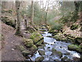
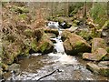
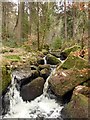
This is so overgrown it's hard to pick any details out.....large stone and rubble bank most visible at the northern end of the fort....the pic shows the stone bank at the N of the fort.
Update January 2018: The Northern Antiquarian (TNA) features a page for what they term a rock shelter or cave, giving a grid reference of SK 2715 8630, which is 100 metres away from the grid reference given here. From their description and 'X marks the spot' on the old OS map included in the TNA page, theirs sounds very much like part of the same site - see their entry for Wyming Brook Shelter, Redmires, Sheffield, South Yorkshire. TNA says: "There are obviously locals who know of it’s existence but after half a dozen visits there I’ve not seen anyone except a brave old lady, 70 if-a-day, who was there looking for the supposed wartime carvings and that was on my first visit ... The shelters entrance is around 3ft high but once inside the roof quickly gains height and tops out at around 7ft so standing is easy ... At the far end of the shelter is a small chimney like opening and it’s just possible to squeeze between the fallen rocks and make your way out, it would also make an excellent outlet for smoke if you chose to have a warming fire inside."
This hillfort is recorded as Pastscape Monument No. 312206, which tells us: "Promontory Fort between sides of Wyming Brook and a stream issuing between the Rivelin Dams at Wyming Brook Corner, NE angle of Ash Cabin Flat, just inside woodland. Walls of large stones end-to-end, backed by rubble and boulders 2-3 metres thick, incorporating in-situ rocks. Outermost walls not continuous; innermost enclosure forming a D-shaped space internally 15m x 16m against the inner wall of rampart. Internal structures suggest round and subrectangular huts. A narrow defile approaches from Wyming Brook to the NE of the site."
Note: Can anyone confirm if the TNA rock shelter is within this promontory fort, or if it is a different site? Thank you.
You may be viewing yesterday's version of this page. To see the most up to date information please register for a free account.
Do not use the above information on other web sites or publications without permission of the contributor.
Nearby Images from Geograph Britain and Ireland:
©2010(licence)
©2019(licence)
©2011(licence)
©2009(licence)
©2019(licence)
The above images may not be of the site on this page, they are loaded from Geograph.
Please Submit an Image of this site or go out and take one for us!
Click here to see more info for this site
Nearby sites
Key: Red: member's photo, Blue: 3rd party photo, Yellow: other image, Green: no photo - please go there and take one, Grey: site destroyed
Download sites to:
KML (Google Earth)
GPX (GPS waypoints)
CSV (Garmin/Navman)
CSV (Excel)
To unlock full downloads you need to sign up as a Contributory Member. Otherwise downloads are limited to 50 sites.
Turn off the page maps and other distractions
Nearby sites listing. In the following links * = Image available
100m W 270° Ash Cabin standing stone* Standing Stone (Menhir) (SK270864)
225m SW 229° Ash Cabin Flat* Stone Circle (SK2693186251)
983m WNW 300° Reddicar Clough (Hallam Moor) Cairn (SK26248688)
1.4km WNW 297° New Hagg (Hallam Moors)* Standing Stone (Menhir) (SK2581587058)
3.9km SW 224° Robin Hood's Cave* Cave or Rock Shelter (SK244836)
4.1km SSE 165° Harrys Stone* Ancient Temple (SK282824)
4.5km SSE 165° God's Spring* Holy Well or Sacred Spring (SK283821)
4.6km SW 234° North Lees Romano British Village* Ancient Village or Settlement (SK2343083673)
4.6km WSW 242° Sheepwash Bank Cairn (SK230842)
4.8km SW 231° Trinity Well (Hathersage)* Holy Well or Sacred Spring (SK234834)
4.9km WSW 242° Dennis Knoll* Cairn (SK228841)
5.0km SSW 193° Carl Wark* Hillfort (SK260815)
5.3km WSW 250° Bamford Moor South* Stone Circle (SK22118453)
5.4km WSW 252° The Old Woman Stone* Standing Stone (Menhir) (SK22018467)
5.4km SSE 159° Giant's Chair (Yorkshire)* Standing Stone (Menhir) (SK291814)
5.4km SSW 200° Winyards Nick* Round Barrow(s) (SK253813)
5.5km S 178° Fingerem Stone* Cairn (SK273809)
5.5km W 265° Moscar Moor* Stone Circle (SK21608591)
5.6km WSW 253° Stone on Bamford Moor* Standing Stone (Menhir) (SK21798470)
5.6km W 275° Seven Stones Of Hordron* Stone Circle (SK2152486851)
5.6km S 176° Ciceley Low I* Ring Cairn (SK2752080782)
5.6km S 176° Ciceley Low II* Ring Cairn (SK2752080782)
5.7km SSW 195° Hathersage Moor Ring Cairn (SK257809)
5.8km WSW 254° Bamford Moor Central* Cairn (SK215848)
5.9km NE 45° Wadsley Common* Stone Circle (SK312906)
View more nearby sites and additional images


 We would like to know more about this location. Please feel free to add a brief description and any relevant information in your own language.
 Wir möchten mehr über diese Stätte erfahren. Bitte zögern Sie nicht, eine kurze Beschreibung und relevante Informationen in Deutsch hinzuzufügen.
 Nous aimerions en savoir encore un peu sur les lieux. S'il vous plaît n'hesitez pas à ajouter une courte description et tous les renseignements pertinents dans votre propre langue.
 Quisieramos informarnos un poco más de las lugares. No dude en añadir una breve descripción y otros datos relevantes en su propio idioma.