Featured: Explore Scotland (and everywhere else) with our Megalithic Portal iPhone app

Explore Scotland (and everywhere else) with our Megalithic Portal iPhone app

Stone Worlds: Narrative and Reflexivity in Landscape Archaeology

Stone Worlds: Narrative and Reflexivity in Landscape Archaeology

Who's Online

There are currently, 270 guests and 3 members online.

You are a guest. To join in, please register for free by clicking here

Sponsors

<< Our Photo Pages >> Ewden Beck - Stone Circle in England in Yorkshire (South)

Submitted by vicky on Wednesday, 18 September 2002  Page Views: 21006

Neolithic and Bronze AgeSite Name: Ewden Beck Alternative Name: Broomhead I
Country: England County: Yorkshire (South) Type: Stone Circle
Nearest Town: Stocksbridge
Map Ref: SK23819664  Landranger Map Number: 110
Latitude: 53.465968N  Longitude: 1.642816W
Condition:
5Perfect
4Almost Perfect
3Reasonable but with some damage
2Ruined but still recognisable as an ancient site
1Pretty much destroyed, possibly visible as crop marks
0No data.
-1Completely destroyed
3 Ambience:
5Superb
4Good
3Ordinary
2Not Good
1Awful
0No data.
2 Access:
5Can be driven to, probably with disabled access
4Short walk on a footpath
3Requiring a bit more of a walk
2A long walk
1In the middle of nowhere, a nightmare to find
0No data.
3 Accuracy:
5co-ordinates taken by GPS or official recorded co-ordinates
4co-ordinates scaled from a detailed map
3co-ordinates scaled from a bad map
2co-ordinates of the nearest village
1co-ordinates of the nearest town
0no data
3

Internal Links:
External Links:

I have visited· I would like to visit

bishop_pam visited on 25th Apr 2021 - their rating: Cond: 2 Amb: 4 Access: 4

BolshieBoris visited on 1st Jan 1982 - their rating: Cond: 2 Amb: 4 Access: 3


Average ratings for this site from all visit loggers: Condition: 2 Ambience: 4 Access: 3.5

Ewden Beck
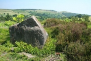
Ewden Beck submitted by PaulM : Close up of some of the stones at Ewden Beck stone circle (aka Broomhead I). GR:SK238966. Ewden Beck is the most northerly of all the known sites in the Peak District to the north-west of Sheffield and west of Stocksbridge and marked on the map as ‘enclosure’. The circle is named after the nearby stream of Ewden Beck and is located on a flat shelf just above the steep valley, in an area surro... (Vote or comment on this photo)
Stone Circle in South Yorkshire. Ewden Beck is the most northerly of all the known sites in the Peak District to the north-west of Sheffield and west of Stocksbridge and marked on the map as ‘enclosure’.

The circle is named after the nearby stream of Ewden Beck and is located on a flat shelf just above the steep valley, in an area surrounded by a bank and ditch of unknown date. As far as the view is concerned, there is very little to see in any direction.

Ewden Beck consists of eight or possibly nine stones (five of which are still standing) in a ring 16m by 14.5m set into the inner edge of an earthen bank. The stones vary in height between about 0.75m and 0.35m, hence the difficulty of recognising not only the stones amongst the vegetation, but also the definition of the ring.

The bank, now barely visible, is approximately 20m in diameter and between 2m and 3m wide into which a single stone is placed to the south-east. To the east it is particularly high where the ground behind drops away. Other stones lie close by and may once have formed part of the ring.

Two entrances, to the north-north-west and south-south-east, both edged with stones are located in the bank, and there are two cairns within the circle. If the stones were evenly spaced there may have been as many as fourteen or fifteen originally with four stones at the entrances.
You may be viewing yesterday's version of this page. To see the most up to date information please register for a free account.

Ewden Beck
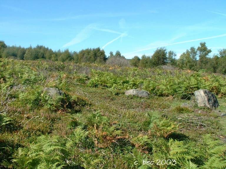
Ewden Beck submitted by bec-zog : Broomhead 1 (Ewden Beck) Circle @ SK2381,9644. Despite what some people say, this is well worth a visit. (Vote or comment on this photo)

Ewden Beck
Ewden Beck submitted by bec-zog : Broomhead 1 (Ewden Beck) Circle @ SK2381,9644 (Vote or comment on this photo)

Ewden Beck
Ewden Beck submitted by bec-zog : Broomhead 1 (Ewden Beck Circle) @ SK2381,9644 (Vote or comment on this photo)

Ewden Beck
Ewden Beck submitted by Bladup : Ewden Beck. (Vote or comment on this photo)

Ewden Beck
Ewden Beck submitted by jumping-buddha : The largest stone in the circle at Ewden beck.

Ewden Beck
Ewden Beck submitted by jumping-buddha : Panoramic shot of Ewden Beck stone circle, with overlay showing rough position and dimensions of the ring.

Do not use the above information on other web sites or publications without permission of the contributor.
Click here to see more info for this site

Nearby sites

Click here to view sites on an interactive OS map

Key: Red: member's photo, Blue: 3rd party photo, Yellow: other image, Green: no photo - please go there and take one, Grey: site destroyed

Download sites to:
KML (Google Earth)
GPX (GPS waypoints)
CSV (Garmin/Navman)
CSV (Excel)

To unlock full downloads you need to sign up as a Contributory Member. Otherwise downloads are limited to 50 sites.

Alastair's Derbyshire Stone Circle Pages by Alastair McIvor
Paul Kenyon`s Database by Paul Kenyon


Turn off the page maps and other distractions

Nearby sites listing. In the following links * = Image available
 2.1km SSE 156° Bar Dyke (Yorkshire)* Misc. Earthwork (SK247947)
 2.2km SSE 162° Bar Dyke Ring* Ring Cairn (SK245946)
 2.2km SSE 162° Apronful of Stones (Bradfield) Cairn (SK2448094582)
 2.9km N 352° St James's Well (Midhopestones)* Holy Well or Sacred Spring (SK234995)
 3.3km SE 139° Handsome Cross Ancient Cross (SK26019412)
 4.5km E 86° Dragon's Well (Bolsterstone) Holy Well or Sacred Spring (SK28279697)
 5.0km NNE 21° Roughbirchworth Camp* Ancient Village or Settlement (SE256013)
 5.0km SE 145° St Nicholas (Bradfield) Ancient Cross (SK26729254)
 5.4km N 356° Cubley Cross* Ancient Cross (SE234020)
 5.5km ENE 75° Deepcar Mesolithic Settlement* Ancient Village or Settlement (SK291981)
 6.7km E 95° Dragon Well (Wharncliffe) Holy Well or Sacred Spring (SK305961)
 7.2km E 95° Burnt Hill Plantation* Rock Art (SK310960)
 9.0km SW 220° Pike Low* Cairn (SK180897)
 9.5km SE 130° Wadsley Common* Stone Circle (SK312906)
 9.6km E 92° Robin Hood Well (Yorkshire South)* Holy Well or Sacred Spring (SK334964)
 9.8km SSE 168° New Hagg (Hallam Moors)* Standing Stone (Menhir) (SK2581587058)
 10.0km NE 51° Stainborough Castle* Hillfort (SE315030)
 10.0km SSW 193° Seven Stones Of Hordron* Stone Circle (SK2152486851)
 10.1km SSE 166° Reddicar Clough (Hallam Moor) Cairn (SK26248688)
 10.3km SSW 200° Ladybower Tor* Rock Art (SK204869)
 10.7km SSE 163° Ash Cabin standing stone* Standing Stone (Menhir) (SK270864)
 10.7km SSW 196° Priddock Wood Cairn (SK209863)
 10.7km SSE 163° Ash Cabin Fort* Hillfort (SK271864)
 10.8km SSE 164° Ash Cabin Flat* Stone Circle (SK2693186251)
 10.9km SSW 192° Moscar Moor* Stone Circle (SK21608591)
View more nearby sites and additional images

<< Ciceley Low I

Eyam Moor III >>

Please add your thoughts on this site

Stone Journals - journeys to the mysterious standing stones of Europe by Patrick Ford

 Stone Journals - journeys to the mysterious standing stones of Europe by Patrick Ford

Archived Web links for Ewden Beck

Alastair's Derbyshire Stone Circle Pages by Alastair McIvor
Paul Kenyon`s Database by Paul Kenyon

Sponsors

Auto-Translation (Google)

Translate from English into:

"Ewden Beck" | Login/Create an Account | 7 News and Comments
  
Go back to top of page    Comments are owned by the poster. We aren't responsible for their content.
Re: Ewden Beck by Frogjuggler on Tuesday, 10 September 2019
(User Info | Send a Message)
Visited today. Most of the stones are hidden under well established bilberry bushes and bracken. There are public footpaths to it or very near but these are lost now. The signs themselves have had their direction pointers removed a long time in the past so I get the impression the people managing the land for grouse are hoping it gets forgotten about possibly?

Will add some photos shortly
[ Reply to This ]

Re: Ewden Beck by Anonymous on Tuesday, 09 July 2013
July 2013
I visited Ewden Beck stone circle yesterday purely through facination. Ignorantly and having no qualifications in the subject I tried to understand it's context within the landscape through interest and curiosity. I was expecting a smaller version of Castle Rigg....very dissapointed. However, I did use my transferable skills by plotting summer/winter astronomical lines aswell as it's position in the landscape. Here are my results (opinions and constructive comments most welcome):

Regardless of where the centre of the circle is (I was stood inside the circle area at all approximate stone positions), I took bearings and discovered that at the summer solstice, the sun rose above and from the v shaped piece of land on a compass bearing of roughly 60 degrees which is north east. It set again in the v shaped piece of land to the north west at roughly 130 degrees.

Winter solstice suggested the sun rising directly above Wigtwizzle with no discernable feature and setting in a similar direction to the near parallel earthwork ditch a few hundred metres to the south. I'm not suggesting that these are related.

Interestingly, noon on both mid summer and mid winter suggested a bearing south, of 185 degrees which coincidence or not, aligns with a v shaped peice of land on the horizon from which a stream seems to start.

With regards to the large 'entrance' stones, they DO NOT appear to align to anything. However, a discernable line of stones run from the 12 position to the 7 oclock position which DOES align to the noon day positions of summer and winter.

My thoughts are that it was assembled (stone circle or barrow or cairn), during the darker months when the sun's position wasn't obvious such as late autumn/winter and corrected when the sun was more obvious like late spring/early summer? Perhaps an adjustment through time. Either way, if your going to move large rocks around you'll need to drink alot of water which could be why it was sited near the stream and at the head of a confluence?

On a broader note, the earthworks just south of the site seem to be a defensive gesture from a percieved threat from further south and protecting the suggested barrows/burials (unconfirmed) to the north of the earthwork some 1.75 mile long that runs in an east/west direction. There are many examples of this. The Cleave Dyke system being one of them which appears to be protecting burials/barrows from a percieved threat mainly from the east.
Could the earthworks at Ewden Beck be a continuance of the Roman Ridge system at Wincobank?

If I were a betting man, I would suggest that if a line was drawn from the centre of the site along the bearings that I suggested this would inevitably cross another important feature just like other sites around the country...Stonehenge burials on the 'noon' line or entrance to the henge on the summer solstice line.....Arbor Low burials on the 'noon' line or entrance to the henge on the solstice line....etc etc...

All contructive feedback and thoughts very, very welcome!
Jessjessop2003@yahoo.co.uk


[ Reply to This ]
    Re: Ewden Beck by Anonymous on Tuesday, 30 July 2013
    Here's my latest theory;
    Small family groups settled several thousands years ago where the farms to the north of the circle are at present. The clean water supply and fertile land provided superb agricultural resources.
    In order to plant crops on time (March/April?), they would need to track the movement of the sun/moon/stars so a stone circle was built using the 'v' shapes in the distant valleys.
    As this was a regular meeting point to monitor the seasons, it seemed fitting to bury the dead there with the oldest being buried nearest to the circle. Over time, generations were buried there (30 known possibly up to 108) radiating away from the circle.
    Sometime in the distant past, a perceived threat arose from the south be it other tribes, Romans, Saxons, Vikings or Normans and a defensive ditch was dug at Bar Dyke to mark the tribal land boundary. As time progressed, another ditch was dug adjacent to the burials and stone circle at Ewden Beck as the community positively secured their manageable tribal area.

    As the threat wained and more of the local inhabitants passed away, so the burial ground was extended further south past the earthworks.

    A Viewshed of strategic points on the map shows a clear view from the Ewden Beck earthwork to the Bar Dyke and from the Bar Dyke to Bradfield...

    Just a thought. Comments, discussions and suggestions very welcome.
    [ Reply to This ]

Re: Ewden Beck by Anonymous on Thursday, 01 July 2010
is bradfield parish meant to look after the site? i went there today and the vegetation is getting worse. could do with burning back again. i have to agree this site is special. im also drawn to bar dyke ring down the road but still have yet to locate some sort of remnant of it =)
[ Reply to This ]

Re: Ewden Beck by Anonymous on Friday, 31 October 2008
hi,i live just a mile away from ewden beck,i spend hours up there,its fantastic at sunset early winter,now..we are holdin a samhain party there tonight,...all welcome...nathan ,...
[ Reply to This ]
    Re: Ewden Beck by Anonymous on Monday, 22 August 2016
    hi Nathan, I saw ur old post. don''t know if you''ll read this but I hope u do. I''m a local too. grew up living at wigtwizzle/broomhead. also celebrate samhain and beltane etc. would be great to do this with others locally. please get in touch! fayetomson@hotmail.com
    [ Reply to This ]

Re: Ewden Beck by jumping-buddha on Monday, 03 July 2006
(User Info | Send a Message)
I visited this site today,03/07/06, and agree, that really, it is well worth a visit..
[ Reply to This ]

Your Name: Anonymous [ Register Now ]
Subject:


Add your comment or contribution to this page. Spam or offensive posts are deleted immediately, don't even bother

<<< What is five plus one as a number? (Please type the answer to this question in the little box on the left)
You can also embed videos and other things. For Youtube please copy and paste the 'embed code'.
For Google Street View please include Street View in the text.
Create a web link like this: <a href="https://www.megalithic.co.uk">This is a link</a>  

Allowed HTML is:
<p> <b> <i> <a> <img> <em> <br> <strong> <blockquote> <tt> <li> <ol> <ul> <object> <param> <embed> <iframe>

We would like to know more about this location. Please feel free to add a brief description and any relevant information in your own language.
Wir möchten mehr über diese Stätte erfahren. Bitte zögern Sie nicht, eine kurze Beschreibung und relevante Informationen in Deutsch hinzuzufügen.
Nous aimerions en savoir encore un peu sur les lieux. S'il vous plaît n'hesitez pas à ajouter une courte description et tous les renseignements pertinents dans votre propre langue.
Quisieramos informarnos un poco más de las lugares. No dude en añadir una breve descripción y otros datos relevantes en su propio idioma.