

<< Our Photo Pages >> Sites of Meaning Marker Stone, Long Dale - Modern Stone Circle etc in England in Derbyshire
Submitted by rogerkread on Wednesday, 26 April 2023 Page Views: 461
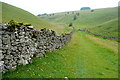
Modern SitesSite Name: Sites of Meaning Marker Stone, Long DaleCountry: England
NOTE: This site is 0.3 km away from the location you searched for.
County: Derbyshire Type: Modern Stone Circle etc
Nearest Town: Bakewell Nearest Village: Middleton-by-Youlgrave
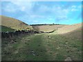
Map Ref: SK1906060254
Latitude: 53.139101N Longitude: 1.716536W
Condition:
| 5 | Perfect |
| 4 | Almost Perfect |
| 3 | Reasonable but with some damage |
| 2 | Ruined but still recognisable as an ancient site |
| 1 | Pretty much destroyed, possibly visible as crop marks |
| 0 | No data. |
| -1 | Completely destroyed |
| 5 | Superb |
| 4 | Good |
| 3 | Ordinary |
| 2 | Not Good |
| 1 | Awful |
| 0 | No data. |
| 5 | Can be driven to, probably with disabled access |
| 4 | Short walk on a footpath |
| 3 | Requiring a bit more of a walk |
| 2 | A long walk |
| 1 | In the middle of nowhere, a nightmare to find |
| 0 | No data. |
| 5 | co-ordinates taken by GPS or official recorded co-ordinates |
| 4 | co-ordinates scaled from a detailed map |
| 3 | co-ordinates scaled from a bad map |
| 2 | co-ordinates of the nearest village |
| 1 | co-ordinates of the nearest town |
| 0 | no data |
Internal Links:
External Links:
")
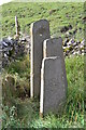
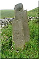
The inscription 'We meet to create memories and depart to cherish them' is taken from a Nepalese tea-house menu! There is a website giving full information about the project, details of all the markers etc: Details Here
You may be viewing yesterday's version of this page. To see the most up to date information please register for a free account.
")
Do not use the above information on other web sites or publications without permission of the contributor.
Nearby Images from Geograph Britain and Ireland:
©2015(licence)
©2012(licence)
©2013(licence)
©2013(licence)
©2013(licence)
The above images may not be of the site on this page, they are loaded from Geograph.
Please Submit an Image of this site or go out and take one for us!
Click here to see more info for this site
Nearby sites
Key: Red: member's photo, Blue: 3rd party photo, Yellow: other image, Green: no photo - please go there and take one, Grey: site destroyed
Download sites to:
KML (Google Earth)
GPX (GPS waypoints)
CSV (Garmin/Navman)
CSV (Excel)
To unlock full downloads you need to sign up as a Contributory Member. Otherwise downloads are limited to 50 sites.
Turn off the page maps and other distractions
Nearby sites listing. In the following links * = Image available
653m NNW 327° Smerril Moor Chambered Cairn (SK187608)
921m NE 54° Borther Lowe Round Barrow(s) (SK1980260803)
1.7km WSW 244° Aleck Low* Round Barrow(s) (SK175595)
2.1km N 2° Rusden Lowe Round Barrow(s) (SK19116231)
2.6km NNE 24° Larks Low Bowl Barrow* Round Barrow(s) (SK20086260)
3.2km SW 216° Parwich Ring Cairn (SK172577)
3.4km SSE 157° Roystone Grange 1 Round Barrow(s) (SK204571)
3.5km W 276° End Low* Round Barrow(s) (SK156606)
3.5km SSE 148° Minning Low* Round Cairn (SK2093557290)
3.7km SE 131° Stoney Low* Chambered Cairn (SK21855784)
3.7km SE 141° Rockhurst Long Barrow (SK214574)
3.8km ENE 63° Dudwood* Stone Circle (SK224620)
3.9km ENE 60° Robin Hood's Stride* Rock Art (SK22476225)
4.0km NE 50° Castle Ring (Derbyshire)* Hillfort (SK221628)
4.0km SSE 161° Roystone Grange 2 Round Barrow(s) (SK204565)
4.0km ENE 58° Robin Hood's Stride* Rock Outcrop (SK225624)
4.1km ENE 59° Robin Hoods Settlement* Ancient Village or Settlement (SK22576238)
4.2km ENE 61° Cratcliff Rocks* Hillfort (SK227623)
4.2km WNW 289° Moneystones* Round Barrow(s) (SK151616)
4.2km NE 56° Nine Stones Close* Stone Circle (SK2253762643)
4.3km NE 54° Nine Stones Cup Mark (Harthill) Rock Art (SK22546284)
4.3km NE 53° Harthill Cairn* Cairn (SK22556286)
4.3km NW 313° Gib Hill Plantation* Misc. Earthwork (SK15876322)
4.5km NW 314° Gib Hill* Long Barrow (SK15826332)
4.5km NW 318° Arbor Low 1* Stone Circle (SK16036355)
View more nearby sites and additional images


 We would like to know more about this location. Please feel free to add a brief description and any relevant information in your own language.
 Wir möchten mehr über diese Stätte erfahren. Bitte zögern Sie nicht, eine kurze Beschreibung und relevante Informationen in Deutsch hinzuzufügen.
 Nous aimerions en savoir encore un peu sur les lieux. S'il vous plaît n'hesitez pas à ajouter une courte description et tous les renseignements pertinents dans votre propre langue.
 Quisieramos informarnos un poco más de las lugares. No dude en añadir una breve descripción y otros datos relevantes en su propio idioma.