


<< Our Photo Pages >> Mainsgill Farm - Modern Stone Circle etc in England in Yorkshire (North)
Submitted by Andy B on Tuesday, 14 June 2011 Page Views: 8757
Modern SitesSite Name: Mainsgill FarmCountry: England County: Yorkshire (North) Type: Modern Stone Circle etc
Nearest Town: Darlington Nearest Village: Ravensworth
Map Ref: NZ154085
Latitude: 54.471634N Longitude: 1.763886W
Condition:
| 5 | Perfect |
| 4 | Almost Perfect |
| 3 | Reasonable but with some damage |
| 2 | Ruined but still recognisable as an ancient site |
| 1 | Pretty much destroyed, possibly visible as crop marks |
| 0 | No data. |
| -1 | Completely destroyed |
| 5 | Superb |
| 4 | Good |
| 3 | Ordinary |
| 2 | Not Good |
| 1 | Awful |
| 0 | No data. |
| 5 | Can be driven to, probably with disabled access |
| 4 | Short walk on a footpath |
| 3 | Requiring a bit more of a walk |
| 2 | A long walk |
| 1 | In the middle of nowhere, a nightmare to find |
| 0 | No data. |
| 5 | co-ordinates taken by GPS or official recorded co-ordinates |
| 4 | co-ordinates scaled from a detailed map |
| 3 | co-ordinates scaled from a bad map |
| 2 | co-ordinates of the nearest village |
| 1 | co-ordinates of the nearest town |
| 0 | no data |
Internal Links:
External Links:
I have visited· I would like to visit
Andy B has visited here
")
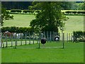
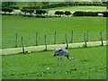
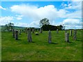
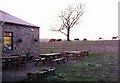
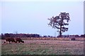
This stone circle can be found at the Mainsgill Farm off the A66. It is made up of old farm gate posts and has been built in the last 5 years as a tourist attraction for visitors to the farm shop and tearooms.
As stone circles go it doesn't look out of place and fits in well with the surroundings.
Mainsgill Farm's web site is www.mainsgillfarm.co.uk, there are more photos of the farm on Geograph
You may be viewing yesterday's version of this page. To see the most up to date information please register for a free account.
Do not use the above information on other web sites or publications without permission of the contributor.
Nearby Images from Geograph Britain and Ireland:
©2011(licence)
©2011(licence)
©2011(licence)
©2005(licence)
©2005(licence)
The above images may not be of the site on this page, they are loaded from Geograph.
Please Submit an Image of this site or go out and take one for us!
Click here to see more info for this site
Nearby sites
Key: Red: member's photo, Blue: 3rd party photo, Yellow: other image, Green: no photo - please go there and take one, Grey: site destroyed
Download sites to:
KML (Google Earth)
GPX (GPS waypoints)
CSV (Garmin/Navman)
CSV (Excel)
To unlock full downloads you need to sign up as a Contributory Member. Otherwise downloads are limited to 50 sites.
Turn off the page maps and other distractions
Nearby sites listing. In the following links * = Image available
3.0km W 274° The Dalton Stone Rock Art (NZ1240008700)
3.9km W 270° Dalton Portable 1 & 2 Rock Art (NZ1150008500)
4.3km WSW 257° Castle Steads* Hillfort (NZ112075)
4.3km SW 226° Feldom Ranges 17b* Rock Art (NZ1229205448)
4.4km WSW 240° Feldom Ranges 8a* Rock Art (NZ1155606266)
4.4km WSW 237° Feldom Ranges 6c* Rock Art (NZ1166906063)
4.5km NNE 33° Stanwick Hillfort* Hillfort (NZ17831229)
4.5km WSW 238° Feldom Ranges 6a* Rock Art (NZ1155506105)
4.6km WSW 239° Feldom Ranges 12a* Rock Art (NZ1146406138)
4.6km SW 235° Feldom Ranges 5a* Rock Art (NZ1164405835)
4.6km NNE 30° St Cuthbert (Forcett)* Ancient Cross (NZ177125)
4.7km NE 42° Stanwick Crosses* Ancient Cross (NZ18511198)
4.7km SW 227° Gayles Moor Slab Rock Art (NZ1200005300)
4.7km WSW 237° Feldom Ranges 15d* Rock Art (NZ1147105928)
4.7km WSW 237° Feldom Ranges 15e* Rock Art (NZ1146105932)
4.7km WSW 237° Feldom Ranges 15c* Rock Art (NZ1146905905)
4.8km NE 43° Kirkbridge Farmhouse Barrow* Round Barrow(s) (NZ187120)
4.9km WSW 238° Feldom Ranges 14a* Rock Art (NZ1127405907)
4.9km WSW 240° Feldom Ranges 13d* Rock Art (NZ1117706029)
5.1km WSW 242° Feldom Ranges 20d* Rock Art (NZ1086106083)
5.8km S 185° Coalsgarth Edge* Rock Art (NZ149027)
6.3km SSE 149° Scots Dyke (Olliver)* Misc. Earthwork (NZ18720309)
6.7km NNW 335° Cockshot Camp* Hillfort (NZ12491458)
6.9km NNW 328° St Mary's Church (Wycliffe)* Ancient Cross (NZ1167314325)
7.1km WNW 286° St Michael & All Angels (Barningham)* Ancient Cross (NZ0853110448)
View more nearby sites and additional images


 We would like to know more about this location. Please feel free to add a brief description and any relevant information in your own language.
 Wir möchten mehr über diese Stätte erfahren. Bitte zögern Sie nicht, eine kurze Beschreibung und relevante Informationen in Deutsch hinzuzufügen.
 Nous aimerions en savoir encore un peu sur les lieux. S'il vous plaît n'hesitez pas à ajouter une courte description et tous les renseignements pertinents dans votre propre langue.
 Quisieramos informarnos un poco más de las lugares. No dude en añadir una breve descripción y otros datos relevantes en su propio idioma.