


<< Text Pages >> Green Crag Slack Enclosure - Ancient Village or Settlement in England in Yorkshire (West)
Submitted by coldrum on Saturday, 16 July 2011 Page Views: 3555
Multi-periodSite Name: Green Crag Slack EnclosureCountry: England County: Yorkshire (West) Type: Ancient Village or Settlement
Map Ref: SE13304590
Latitude: 53.909088N Longitude: 1.799033W
Condition:
| 5 | Perfect |
| 4 | Almost Perfect |
| 3 | Reasonable but with some damage |
| 2 | Ruined but still recognisable as an ancient site |
| 1 | Pretty much destroyed, possibly visible as crop marks |
| 0 | No data. |
| -1 | Completely destroyed |
| 5 | Superb |
| 4 | Good |
| 3 | Ordinary |
| 2 | Not Good |
| 1 | Awful |
| 0 | No data. |
| 5 | Can be driven to, probably with disabled access |
| 4 | Short walk on a footpath |
| 3 | Requiring a bit more of a walk |
| 2 | A long walk |
| 1 | In the middle of nowhere, a nightmare to find |
| 0 | No data. |
| 5 | co-ordinates taken by GPS or official recorded co-ordinates |
| 4 | co-ordinates scaled from a detailed map |
| 3 | co-ordinates scaled from a bad map |
| 2 | co-ordinates of the nearest village |
| 1 | co-ordinates of the nearest town |
| 0 | no data |
Be the first person to rate this site - see the 'Contribute!' box in the right hand menu.
Internal Links:
External Links:
Ancient Settlement in Yorkshire (West)
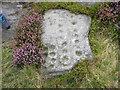
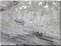
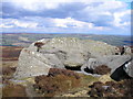
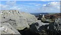
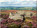
Fragmentary remains of field walls, an enclosure and cairns, possibly Bronze Age.
Source: Pastscape
You may be viewing yesterday's version of this page. To see the most up to date information please register for a free account.
Do not use the above information on other web sites or publications without permission of the contributor.
Nearby Images from Geograph Britain and Ireland:
©2015(licence)
©2016(licence)
©2016(licence)
©2022(licence)
©2005(licence)
The above images may not be of the site on this page, they are loaded from Geograph.
Please Submit an Image of this site or go out and take one for us!
Click here to see more info for this site
Nearby sites
Key: Red: member's photo, Blue: 3rd party photo, Yellow: other image, Green: no photo - please go there and take one, Grey: site destroyed
Download sites to:
KML (Google Earth)
GPX (GPS waypoints)
CSV (Garmin/Navman)
CSV (Excel)
To unlock full downloads you need to sign up as a Contributory Member. Otherwise downloads are limited to 50 sites.
Turn off the page maps and other distractions
Nearby sites listing. In the following links * = Image available
5m WSW 244° Green Crag Slack 09* Rock Art (SE1329645898)
26m NW 320° Green Crag Slack 08* Rock Art (SE1328345920)
28m NW 315° Green Crag Slack* Rock Art (SE13284592)
51m S 171° Green Crag Slack 10* Rock Art (SE1330845850)
55m NW 320° Green Crag Slack 05* Rock Art (SE1326545942)
55m NW 321° Idol Stone* Rock Art (SE1326545943)
56m NW 322° Green Crag Slack 06* Rock Art (SE1326545944)
57m NW 322° Green Crag Slack 07* Rock Art (SE1326545945)
89m NW 309° Green Crag Slack 04* Rock Art (SE1323045956)
90m WNW 294° Green Crag Slack 02* Rock Art (SE1321845937)
91m W 281° Green Crag Slack 01* Rock Art (SE1321045917)
93m WNW 301° Green Crag Slack 03* Rock Art (SE1322045948)
141m NW 308° Green Crag 12a* Rock Art (SE1318845986)
175m WNW 301° Green Crag 14* Rock Art (SE1314945989)
216m WSW 256° Green Crag 12.* Rock Art (SE1309045847)
219m WNW 296° Green Crag 13* Rock Art (SE1310245994)
220m WNW 284° Green Crag 11* Rock Art (SE1308645953)
223m WSW 244° Green Crag Top (Ilkley Moor) Cairn (SE131458)
226m NE 45° Mini Skirtful of Stones (Ilkley Moor) Cairn (SE13464606)
261m SE 125° Green Crag 16* Rock Art (SE1351445750)
265m NNE 14° Pancake Ridge 12 Rock Art (SE1336546157)
280m SE 125° Green Crag 17 Rock Art (SE1353045740)
282m SW 225° Green Crag Plain (Ilkley Moor) Standing Stone (Menhir) (SE131457)
295m NNE 24° Pancake Ridge 13 Rock Art (SE1342046170)
302m SW 218° Lanshaw Delves 03* Rock Art (SE1311545661)
View more nearby sites and additional images


 We would like to know more about this location. Please feel free to add a brief description and any relevant information in your own language.
 Wir möchten mehr über diese Stätte erfahren. Bitte zögern Sie nicht, eine kurze Beschreibung und relevante Informationen in Deutsch hinzuzufügen.
 Nous aimerions en savoir encore un peu sur les lieux. S'il vous plaît n'hesitez pas à ajouter une courte description et tous les renseignements pertinents dans votre propre langue.
 Quisieramos informarnos un poco más de las lugares. No dude en añadir una breve descripción y otros datos relevantes en su propio idioma.