


<< Our Photo Pages >> Hunterheugh 4 - Rock Art in England in Northumberland
Submitted by SolarMegalith on Friday, 10 May 2013 Page Views: 1935
Rock ArtSite Name: Hunterheugh 4 Alternative Name: ERA-475; Beckensall 343Country: England
NOTE: This site is 0.6 km away from the location you searched for.
County: Northumberland Type: Rock Art
Nearest Town: Alnwick Nearest Village: Eglingham
Map Ref: NU1189516801
Latitude: 55.444939N Longitude: 1.813521W
Condition:
| 5 | Perfect |
| 4 | Almost Perfect |
| 3 | Reasonable but with some damage |
| 2 | Ruined but still recognisable as an ancient site |
| 1 | Pretty much destroyed, possibly visible as crop marks |
| 0 | No data. |
| -1 | Completely destroyed |
| 5 | Superb |
| 4 | Good |
| 3 | Ordinary |
| 2 | Not Good |
| 1 | Awful |
| 0 | No data. |
| 5 | Can be driven to, probably with disabled access |
| 4 | Short walk on a footpath |
| 3 | Requiring a bit more of a walk |
| 2 | A long walk |
| 1 | In the middle of nowhere, a nightmare to find |
| 0 | No data. |
| 5 | co-ordinates taken by GPS or official recorded co-ordinates |
| 4 | co-ordinates scaled from a detailed map |
| 3 | co-ordinates scaled from a bad map |
| 2 | co-ordinates of the nearest village |
| 1 | co-ordinates of the nearest town |
| 0 | no data |
Internal Links:
External Links:
I have visited· I would like to visit
SolarMegalith visited on 4th May 2013 - their rating: Cond: 2 Amb: 4 Access: 3
")
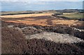
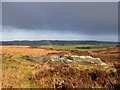
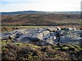
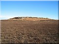
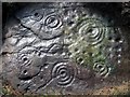
This panel is part of a rocky crag, it is located immediately next to Hunterheugh 5. The motifs include three heavily eroded cups with single rings and a possible linear groove. I could distinguish only one very eroded cup-and-ring mark during my visit.
For more information see England's Rock Art entry for ERA-476 Hunterheugh 4, which includes both NADRAP's and Beckensall's descriptions, photographs, a sketch of the rock and its motifs, photogrammetry, a VRML model and media from the Beckensall Archive.
The original Beckensall record can be found at Internet Archive: Beckensall 343 Hunterheugh 4.
This rock art panel is located on Open Access land. Beckensall noted this panel was more than 100m from the nearest path.
You may be viewing yesterday's version of this page. To see the most up to date information please register for a free account.
")
")
Do not use the above information on other web sites or publications without permission of the contributor.
Nearby Images from Geograph Britain and Ireland:
©2009(licence)
©2009(licence)
©2009(licence)
©2008(licence)
©2020(licence)
The above images may not be of the site on this page, they are loaded from Geograph.
Please Submit an Image of this site or go out and take one for us!
Click here to see more info for this site
Nearby sites
Key: Red: member's photo, Blue: 3rd party photo, Yellow: other image, Green: no photo - please go there and take one, Grey: site destroyed
Download sites to:
KML (Google Earth)
GPX (GPS waypoints)
CSV (Garmin/Navman)
CSV (Excel)
To unlock full downloads you need to sign up as a Contributory Member. Otherwise downloads are limited to 50 sites.
Turn off the page maps and other distractions
Nearby sites listing. In the following links * = Image available
3m WSW 252° Hunterheugh 5* Rock Art (NU1189216800)
145m W 265° Hunterheugh 1.* Rock Art (NU1175016787)
146m W 262° Hunterheugh Excavation Portable Panels Rock Art (NU1175016780)
201m WNW 294° Hunterheugh 7 Rock Art (NU1171116882)
206m WNW 281° Hunterheugh 2* Rock Art (NU1169216841)
212m W 273° Hunterheugh 3* Rock Art (NU1168316811)
228m WSW 258° Hunterheugh 12 Rock Art (NU1167116754)
280m WSW 251° Hunterheugh 8h Rock Art (NU1163016708)
286m WSW 251° Hunterheugh 8b Rock Art (NU1162316709)
299m WSW 249° Hunterheugh 8c Rock Art (NU1161516693)
302m WSW 249° Hunterheugh 8g Rock Art (NU1161216692)
306m WSW 249° Hunterheugh 8d Rock Art (NU1160916689)
308m WSW 249° Hunterheugh 8e Rock Art (NU1160716690)
310m WSW 249° Hunterheugh 8f Rock Art (NU1160516688)
311m WSW 248° Hunterheugh 8a Rock Art (NU1160516686)
339m W 281° Hunterheugh 13* Rock Art (NU1156116863)
340m W 281° Hunterheugh 14* Rock Art (NU1156016866)
384m WSW 254° Hunterheugh 9 Rock Art (NU1152616691)
428m W 280° Hunterheugh 11 Rock Art (NU1147216873)
432m WSW 253° Hunterheugh 10 Rock Art (NU1148116674)
487m WNW 282° Hunterheugh 6* Rock Art (NU1141816904)
512m WNW 282° Hunterheugh 6b Rock Art (NU1139216904)
1.3km SSE 158° Midstead 5 Rock Art (NU1240115583)
1.4km SSE 159° Midstead 1* Rock Art (NU1242115460)
1.6km S 172° Midstead 2* Rock Art (NU1211515191)
View more nearby sites and additional images


 We would like to know more about this location. Please feel free to add a brief description and any relevant information in your own language.
 Wir möchten mehr über diese Stätte erfahren. Bitte zögern Sie nicht, eine kurze Beschreibung und relevante Informationen in Deutsch hinzuzufügen.
 Nous aimerions en savoir encore un peu sur les lieux. S'il vous plaît n'hesitez pas à ajouter une courte description et tous les renseignements pertinents dans votre propre langue.
 Quisieramos informarnos un poco más de las lugares. No dude en añadir una breve descripción y otros datos relevantes en su propio idioma.