


<< Our Photo Pages >> Ashlar Chair 01 - Rock Outcrop in England in Yorkshire (West)
Submitted by andy_h on Sunday, 14 December 2003 Page Views: 11082
Natural PlacesSite Name: Ashlar Chair 01 Alternative Name: ERA-2498; PRN203Country: England County: Yorkshire (West) Type: Rock Outcrop
Nearest Town: Ilkley
Map Ref: SE1207544838 Landranger Map Number: 104
Latitude: 53.899572N Longitude: 1.817721W
Condition:
| 5 | Perfect |
| 4 | Almost Perfect |
| 3 | Reasonable but with some damage |
| 2 | Ruined but still recognisable as an ancient site |
| 1 | Pretty much destroyed, possibly visible as crop marks |
| 0 | No data. |
| -1 | Completely destroyed |
| 5 | Superb |
| 4 | Good |
| 3 | Ordinary |
| 2 | Not Good |
| 1 | Awful |
| 0 | No data. |
| 5 | Can be driven to, probably with disabled access |
| 4 | Short walk on a footpath |
| 3 | Requiring a bit more of a walk |
| 2 | A long walk |
| 1 | In the middle of nowhere, a nightmare to find |
| 0 | No data. |
| 5 | co-ordinates taken by GPS or official recorded co-ordinates |
| 4 | co-ordinates scaled from a detailed map |
| 3 | co-ordinates scaled from a bad map |
| 2 | co-ordinates of the nearest village |
| 1 | co-ordinates of the nearest town |
| 0 | no data |
Internal Links:
External Links:
I have visited· I would like to visit
markj99 visited on 21st Jan 2009 - their rating: Cond: 3 Amb: 5 Access: 2 I have an attraction to sites which are difficult to reach. I would rather walk several miles over bleak moorland to find a random stone than walk 10 yards on a footpath to a more spectacular site by the roadside. Therefore Ashlar Chair was too tempting to ignore, a rough diamond in unforgiving terrain. I gained a great deal of satisfaction in finding Ashlar Chair, unspectacular as it is.
")
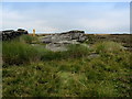
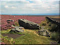
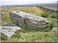
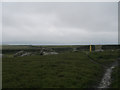
This heavily weathered rock lays at the meeting point of four moors. Ilkley Moor, Burley Moor, Morton Moor and Bingley Moor. Cup and ring carvings were recorded in the 19th C, but these have now weathered away and no trace remains. Paul Bennett describes the rock as an 'Omphalus' or a universal centre. It's name probably comes from it's use by medieval masons. It was also used as a meeting point for the Pendle Witches. SE1208 4483.
For more information see Paul Bennett's The Northern Antiquarian's page for the Ashlar Chair, Burley Moor, West Yorkshire which has directions for finding this outcrop, together with photographs, a brief archaeology & history and an 1851 map.
This rock art panel is also recorded as England's Rock Art ERA-2498 Ashlar Chair 01, which gives a description and includes photographs and a plan of this rock and its motifs.
This rock is located on Open Access land.
You may be viewing yesterday's version of this page. To see the most up to date information please register for a free account.
")
")
Do not use the above information on other web sites or publications without permission of the contributor.
Nearby Images from Geograph Britain and Ireland:
©2013(licence)
©2005(licence)

©2019(licence)
©2008(licence)
©2012(licence)
The above images may not be of the site on this page, they are loaded from Geograph.
Please Submit an Image of this site or go out and take one for us!
Click here to see more info for this site
Nearby sites
Key: Red: member's photo, Blue: 3rd party photo, Yellow: other image, Green: no photo - please go there and take one, Grey: site destroyed
Download sites to:
KML (Google Earth)
GPX (GPS waypoints)
CSV (Garmin/Navman)
CSV (Excel)
To unlock full downloads you need to sign up as a Contributory Member. Otherwise downloads are limited to 50 sites.
Turn off the page maps and other distractions
Nearby sites listing. In the following links * = Image available
578m ENE 68° Twelve Apostles (Yorks)* Stone Circle (SE12614506)
664m ENE 56° Lanshaw Lad 01* Rock Art (SE1262845208)
710m NW 304° White Crag Moss 01* Rock Art (SE1148445234)
714m WNW 302° Rombalds Moor Cairn* Cairn (SE11474522)
819m NW 322° White Crag Moss 02* Rock Art (SE1157045484)
823m NE 36° Lanshaw Delves 06* Rock Art (SE1255845506)
964m N 356° Ilkley Moor Labyrinth* Modern Stone Circle etc (SE120458)
1.0km NE 55° Lanshaw Delves 01* Rock Art (SE1292045423)
1.2km ENE 61° Lanshaw Delves 02* Rock Art (SE1308945406)
1.2km WNW 285° Thimble Stones 01* Rock Art (SE1089045150)
1.2km ENE 59° Lanshaw Delves 05* Rock Art (SE1314245472)
1.2km ENE 58° Lanshaw Delves 04* Rock Art (SE1313245492)
1.3km ENE 62° Lanshaw Lass* Standing Stone (Menhir) (SE13204545)
1.3km NNE 22° Gill Head 01* Rock Art (SE1255846027)
1.3km SE 124° Elkington's Track (Burley Moor) Ancient Trackway (SE1316944111)
1.3km NE 52° Lanshaw Delves 03* Rock Art (SE1311545661)
1.3km NNW 335° Green Gates 05* Rock Art (SE1149846045)
1.3km NE 50° Green Crag Plain (Ilkley Moor) Standing Stone (Menhir) (SE131457)
1.3km NNW 335° Green Gates 06* Rock Art (SE1149946049)
1.3km NE 40° Green Crag 03* Rock Art (SE1293745876)
1.3km NE 36° Green Crag 02* Rock Art (SE1286645931)
1.4km NNE 34° Green Crag 01* Rock Art (SE1283145976)
1.4km NE 39° Green Crag 06* Rock Art (SE1293145908)
1.4km NNW 332° Green Gates 04* Rock Art (SE1141746040)
1.4km NE 39° Green Crag 04* Rock Art (SE1293045913)
View more nearby sites and additional images


 We would like to know more about this location. Please feel free to add a brief description and any relevant information in your own language.
 Wir möchten mehr über diese Stätte erfahren. Bitte zögern Sie nicht, eine kurze Beschreibung und relevante Informationen in Deutsch hinzuzufügen.
 Nous aimerions en savoir encore un peu sur les lieux. S'il vous plaît n'hesitez pas à ajouter une courte description et tous les renseignements pertinents dans votre propre langue.
 Quisieramos informarnos un poco más de las lugares. No dude en añadir una breve descripción y otros datos relevantes en su propio idioma.