
, Aubrey Burl")
<< Our Photo Pages >> Fargo Disk Barrow - Round Barrow(s) in England in Wiltshire
Submitted by AngieLake on Tuesday, 16 July 2019 Page Views: 5855
Neolithic and Bronze AgeSite Name: Fargo Disk Barrow Alternative Name: Stonehenge Cursus Barrow Group, Great Cursus BarrowsCountry: England County: Wiltshire Type: Round Barrow(s)
Nearest Town: Amesbury Nearest Village: Winterbourne Stoke
Map Ref: SU11154275
Latitude: 51.183873N Longitude: 1.841853W
Condition:
| 5 | Perfect |
| 4 | Almost Perfect |
| 3 | Reasonable but with some damage |
| 2 | Ruined but still recognisable as an ancient site |
| 1 | Pretty much destroyed, possibly visible as crop marks |
| 0 | No data. |
| -1 | Completely destroyed |
| 5 | Superb |
| 4 | Good |
| 3 | Ordinary |
| 2 | Not Good |
| 1 | Awful |
| 0 | No data. |
| 5 | Can be driven to, probably with disabled access |
| 4 | Short walk on a footpath |
| 3 | Requiring a bit more of a walk |
| 2 | A long walk |
| 1 | In the middle of nowhere, a nightmare to find |
| 0 | No data. |
| 5 | co-ordinates taken by GPS or official recorded co-ordinates |
| 4 | co-ordinates scaled from a detailed map |
| 3 | co-ordinates scaled from a bad map |
| 2 | co-ordinates of the nearest village |
| 1 | co-ordinates of the nearest town |
| 0 | no data |
Internal Links:
External Links:
I have visited· I would like to visit
Richard13 visited on 1st Jan 2014 - their rating: Cond: 2 Amb: 4 Access: 3
")
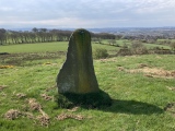
Angie Lake writes: On 19th June 2012, Rangers (presumably working for the National Trust) told me about this site. Jackie and I had been in the plantation, investigating a possible small 'henge' (dowsed by Angie and late friend Alex in May 2010) near the large barrow* in the woods just south of the west end of The Great Cursus - *(not the 'Monarch', btw) - when a young man and woman stopped to chat. (They were probably looking for illegal Solstice campers and thought we were setting up camp! ;-))
In the course of discussion he said he'd seen my name on the Megalithic Portal, and went on to tell us about a newly-cleared site we might like to take a look at.
He explained that we should go back to the north/south footpath through the trees (accessed by the stile just south of the west end of the Cursus), then look to our left and we'd see the clearing.
There was only one possible place this could be, which we accessed by a hardly-noticable track through the undergrowth.
Though it was not obviously recognisable as a disk barrow, while walking around the perimeter of the area we noticed several small red plastic pegs sticking out of the ground, and a small red flag. Presumably these marked certain features (inner or outer ring) of the disk barrow.
While googling for information I came upon a diagram of the barrows in this area on a website with an email link to a 'Chris Collyer':
http://www.stone-circles.org.uk/stone/cursusgroup.htm
It clearly shows the site of the disk barrow and would be very useful to have a copy on the Portal pages.
Note: Beyond Stonehenge Walk: What Makes A World Heritage Site Landscape, 27th July. Note, I don't know where they are visiting on the walk, but I chose an interesting and little known barrow near the visitor centre that they might well visit
You may be viewing yesterday's version of this page. To see the most up to date information please register for a free account.
")
")
")
")
")
")
")
Do not use the above information on other web sites or publications without permission of the contributor.
Click here to see more info for this site
Nearby sites
Key: Red: member's photo, Blue: 3rd party photo, Yellow: other image, Green: no photo - please go there and take one, Grey: site destroyed
Download sites to:
KML (Google Earth)
GPX (GPS waypoints)
CSV (Garmin/Navman)
CSV (Excel)
To unlock full downloads you need to sign up as a Contributory Member. Otherwise downloads are limited to 50 sites.
Turn off the page maps and other distractions
Nearby sites listing. In the following links * = Image available
183m NNW 331° Great Cursus W Barrow* Round Barrow(s) (SU11064291)
291m WNW 301° Amesbury Cursus (W)* Cursus (SU109429)
739m E 88° Great Cursus Barrows, Stonehenge* Round Barrow(s) (SU11894278)
917m ESE 113° Stonehenge Car Park Postholes* Timber Circle (SU120424)
931m ENE 77° Great Cursus, Stonehenge* Cursus (SU12064296)
961m NNW 332° Winterbourne Stoke Cursus (E) Cursus (SU107436)
1.0km NW 311° The Lesser Cursus* Cursus (SU10354343)
1.0km W 273° Stonehenge Visitor Centre* Museum (SU101428)
1.1km NW 308° Winterbourne Stoke Cursus (W) Cursus (SU103434)
1.1km SSE 159° North of Normanton Gorse Barrows* Barrow Cemetery (SU1154441754)
1.2km WSW 251° North of Winterbourne Stoke Crossroads* Barrow Cemetery (SU1004742378)
1.2km ESE 117° Stonehenge.* Stone Circle (SU1224742194)
1.2km ESE 114° Heel Stone* Standing Stone (Menhir) (SU1229142244)
1.3km SSW 193° Pond Barrow and Wilsford Shaft Round Barrow(s) (SU1086441475)
1.4km ESE 115° Stonehenge Bowl Barrow* Round Barrow(s) (SU12424217)
1.4km SW 223° Winterbourne Stoke* Barrow Cemetery (SU10174171)
1.5km E 95° The Avenue* Ancient Trackway (SU12694262)
1.6km SSE 162° Bush Barrow* Round Barrow(s) (SU11644126)
1.7km SW 221° Long Barrow Cross* Ancient Cross (SU1005441499)
1.7km SSE 157° Normanton Down* Barrow Cemetery (SU118412)
1.7km S 171° Normanton Down Long Barrow* Long Barrow (SU1141341071)
2.1km NE 39° Long Barrow alongside The Packway, Larkhill* Long Barrow (SU12474438)
2.1km ESE 110° Amesbury 39 Bowl Barrow* Round Barrow(s) (SU13154204)
2.4km ESE 103° New King Barrows* Barrow Cemetery (SU13454222)
2.4km E 89° Old King Barrows* Barrow Cemetery (SU13604280)
View more nearby sites and additional images


 We would like to know more about this location. Please feel free to add a brief description and any relevant information in your own language.
 Wir möchten mehr über diese Stätte erfahren. Bitte zögern Sie nicht, eine kurze Beschreibung und relevante Informationen in Deutsch hinzuzufügen.
 Nous aimerions en savoir encore un peu sur les lieux. S'il vous plaît n'hesitez pas à ajouter une courte description et tous les renseignements pertinents dans votre propre langue.
 Quisieramos informarnos un poco más de las lugares. No dude en añadir una breve descripción y otros datos relevantes en su propio idioma.