


<< Our Photo Pages >> Prudhoe Castle - Rock Art in England in Northumberland
Submitted by Anne T on Sunday, 27 March 2016 Page Views: 1786
Rock ArtSite Name: Prudhoe Castle Alternative Name: ERA-750; Beckensall 750; SAM 23228; SMR/HER N10118Country: England County: Northumberland Type: Rock Art
Nearest Town: Hexham Nearest Village: Prudhoe
Map Ref: NZ09186342
Latitude: 54.965325N Longitude: 1.858151W
Condition:
| 5 | Perfect |
| 4 | Almost Perfect |
| 3 | Reasonable but with some damage |
| 2 | Ruined but still recognisable as an ancient site |
| 1 | Pretty much destroyed, possibly visible as crop marks |
| 0 | No data. |
| -1 | Completely destroyed |
| 5 | Superb |
| 4 | Good |
| 3 | Ordinary |
| 2 | Not Good |
| 1 | Awful |
| 0 | No data. |
| 5 | Can be driven to, probably with disabled access |
| 4 | Short walk on a footpath |
| 3 | Requiring a bit more of a walk |
| 2 | A long walk |
| 1 | In the middle of nowhere, a nightmare to find |
| 0 | No data. |
| 5 | co-ordinates taken by GPS or official recorded co-ordinates |
| 4 | co-ordinates scaled from a detailed map |
| 3 | co-ordinates scaled from a bad map |
| 2 | co-ordinates of the nearest village |
| 1 | co-ordinates of the nearest town |
| 0 | no data |
Internal Links:
External Links:
I have visited· I would like to visit
SolarMegalith visited on 12th Oct 2016 - their rating: Cond: 3 Amb: 3 Access: 5
Anne T visited on 26th Mar 2016 - their rating: Cond: 3 Amb: 4 Access: 4 Rock Art @ Prudhoe Castle, Northumberland: I only found out about this stone because I'd been doing some research for the Tynedale North of the Wall Archaeology Group and spotted a record for Prudhoe Castle on the ERA web site (also another one in the Monastic Workshop in Hexham Abbey, which I’ve emailed them about). We’ve lived here for almost 14 years and never been to the castle. I confess to it being prettier than I’d imagined.
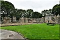
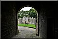
Coming up from the Badger Roundabout in Low Prudhoe (junction of the A695 with Station Road), the access road seems pretty tight, although it is wider than it appears. The car park is about 100 yards from the main entrance of the castle. There is a pond to the left of the gate, fed from a stream which is piped under the road from the hillside behind. There are some really nice yew block hedges which really make the entrance. If the trees were out in leaf, you wouldn’t be able to see the castle from the road.
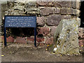
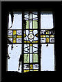
The path climbs gently up the slope, through the gatehouse and under the gatehouse with chapel over. This leads into the outer bailey and immediately in front of you the block with rock art stands against the sloping north wall of the castle, with the ticket office to the left hand side. The sign next to it reads “prehistoric cup and ring marked stone found reused in the footings of a late medieval building on this site.” England’s Rock Art record (ERA-750) tell us that “this stone is very close to the north wall of the castle building (about 0.32m), by a small window. The carved surface faces south to the castle gateway and is in a fairly sheltered position and gets the sun. It was found during excavations of a 14th century hall within the castle. Motifs consist of two, possibly three single cups and two larger cups with multiple rings, the lower cup has three rings and the higher has two, both the outer rings overlap. The rings could be pennannulars, but they’re extremely faint and difficult to make out. Short radial grooves run from the central cups.”
The outer bailey is quite fascinating. When there were no trees (and no toilet roll factory) there would have been brilliant views across the Tyne towards Ovingham.
A footpath runs around the castle in a ditch and we walked round, seeing the foundations of a round tower that once stood. There are the remains of a mill to the left hand side as you leave the gatehouse, with an old mill stone dated 1786 propped by the wall. The old mill leat runs along a paved bed of stones and runs down to the Tyne below.
Average ratings for this site from all visit loggers: Condition: 3 Ambience: 3.5 Access: 4.5
")
The large black sign immediately adjacent to this rock art block declares "prehistoric cup and ring marked stone found reused in the footings of a late medieval building on this site." The stone sits next to the sloping north wall of Prudhoe Castle, between the remains of what was the Great Hall and what is now the house/ticket office.
For more information see England's Rock Art entry for ERA-750 Prudhoe Castle which states “this stone is very close to the north wall of the castle building (about 0.32m), by a small window". The ERA record also has NADRAP's and Beckensall's Archive notes, photographs, a sketch of the stone and its motifs, plus photogrammetry, a VRML model and media from the Beckensall Archive. The original Beckensall record can be found at Internet Archive: Beckensall 750 Prudhoe Castle.
> The carved surface of this stone faces south to the castle gateway and is in a fairly sheltered position and gets the sun. It was found during excavations of a 14th century hall within the castle. Motifs consist of two, possibly three single cups and two larger cups with multiple rings, the lower cup has three rings and the higher has two, both the outer rings overlap. The rings could be pennannulars, but they’re extremely faint and difficult to make out. Short radial grooves run from the central cups.” Note the ERA record gives the wrong grid reference (theirs leads you to a site on the northern side of the Tyne in Ovingham).
Prudhoe Castle dates from around 1070 and (quoting from the English Heritage Guidebook) "stands high on a natural platform above the River Tyne .... guarding the river crossing and looking north to the Border country." Until the 19th century, the views over the River Tyne and Ovingham would have been beautiful. Now the views from the northern side of the castle are of the toilet roll factory below.
It can be reached from the A695, turning uphill along Station Road at what is know locally as the Badger Roundabout (there is a stone badger built into the hillside on the south side of the roundabout). Some 300 yards up the hill there is a turning to the left hand side of the road signposted towards the castle. Just over 100 metres along this side road there is a small car park (which closes at 6pm). The stone is located about 150 meters from the gated entrance to the castle, but is an easy walk up a sloping, paved roadway.
Across the bridge St Mary's Church in Ovingham with it's Anglo Saxon cross shafts and cross head.
You may be viewing yesterday's version of this page. To see the most up to date information please register for a free account.
")
")
")
")
Do not use the above information on other web sites or publications without permission of the contributor.
Nearby Images from Geograph Britain and Ireland:
©2019(licence)
©2019(licence)
©2023(licence)
©2023(licence)
©2023(licence)
The above images may not be of the site on this page, they are loaded from Geograph.
Please Submit an Image of this site or go out and take one for us!
Click here to see more info for this site
Nearby sites
Key: Red: member's photo, Blue: 3rd party photo, Yellow: other image, Green: no photo - please go there and take one, Grey: site destroyed
Download sites to:
KML (Google Earth)
GPX (GPS waypoints)
CSV (Garmin/Navman)
CSV (Excel)
To unlock full downloads you need to sign up as a Contributory Member. Otherwise downloads are limited to 50 sites.
Turn off the page maps and other distractions
Nearby sites listing. In the following links * = Image available
733m WNW 293° Ovingham Cross* Ancient Cross (NZ08506370)
2.0km NW 308° Eddybroth Well (Whittle Dene)* Holy Well or Sacred Spring (NZ0760464659)
2.2km WNW 282° St Andrew's Well (Ovington)* Holy Well or Sacred Spring (NZ0697563896)
2.4km N 5° Croft's Well (Horsley)* Holy Well or Sacred Spring (NZ0939965821)
2.5km NW 306° Hunters Hill (Ovington) Rock Art (NZ0711064900)
2.8km N 2° Horsley Hill Homestead* Ancient Village or Settlement (NZ09266624)
3.0km SE 132° North View enclosure* Ancient Village or Settlement (NZ114614)
3.0km E 92° Bradley Hall Ice House Barrow Round Barrow(s) (NZ12236333)
3.3km W 275° Entry Well (Ovington)* Holy Well or Sacred Spring (NZ0589163703)
3.3km E 94° Bradley Hall Dene Barrow Round Barrow(s) (NZ12536317)
4.0km ENE 73° Simmery Hill Cist, Clara Vale* Cist (NZ13026462)
4.0km ESE 107° White Well, Greenside* Holy Well or Sacred Spring (NZ13036222)
4.4km NE 44° Houghton Camp, Heddon on the Hill* Ancient Village or Settlement (NZ12246657)
4.7km WSW 246° Bywell Cross* Ancient Cross (NZ0489661513)
4.7km WSW 245° St Peter's (Bywell)* Early Christian Sculptured Stone (NZ0492261422)
4.8km WSW 246° St Andrew's Church (Bywell)* Ancient Cross (NZ04836148)
5.2km ENE 76° Ryton 3 Rock Art (NZ1420064700)
5.3km E 89° Ryton 2 Rock Art (NZ1450063500)
5.4km NE 51° St Andrew's Church (Heddon on the Wall)* Ancient Cross (NZ1338666892)
5.6km E 89° The Ryton Stone Rock Art (NZ1475063500)
5.6km NE 52° Hadrian's Wall (Heddon on the Wall)* Misc. Earthwork (NZ13616693)
5.7km E 82° Ryton 1 Rock Art (NZ1480064170)
5.7km SE 142° Ceoppa's Barrow* Round Barrow(s) (NZ1270258908)
6.0km ESE 107° Holy Well, Greenside* Holy Well or Sacred Spring (NZ14936170)
6.1km ENE 77° Ryton Motte or Tumulus* Artificial Mound (NZ15176483)
View more nearby sites and additional images


 We would like to know more about this location. Please feel free to add a brief description and any relevant information in your own language.
 Wir möchten mehr über diese Stätte erfahren. Bitte zögern Sie nicht, eine kurze Beschreibung und relevante Informationen in Deutsch hinzuzufügen.
 Nous aimerions en savoir encore un peu sur les lieux. S'il vous plaît n'hesitez pas à ajouter une courte description et tous les renseignements pertinents dans votre propre langue.
 Quisieramos informarnos un poco más de las lugares. No dude en añadir una breve descripción y otros datos relevantes en su propio idioma.