 with our Megalithic Portal iPhone app")


<< Our Photo Pages >> Tan Hill Cross Dyke - Misc. Earthwork in England in Wiltshire
Submitted by dooclay on Wednesday, 01 February 2023 Page Views: 2138
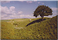
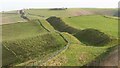
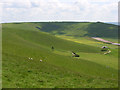
Multi-periodSite Name: Tan Hill Cross DykeCountry: England County: Wiltshire Type: Misc. Earthwork
Nearest Village: Allington
Map Ref: SU0900364643
Latitude: 51.380767N Longitude: 1.872026W
Condition:
| 5 | Perfect |
| 4 | Almost Perfect |
| 3 | Reasonable but with some damage |
| 2 | Ruined but still recognisable as an ancient site |
| 1 | Pretty much destroyed, possibly visible as crop marks |
| 0 | No data. |
| -1 | Completely destroyed |
| 5 | Superb |
| 4 | Good |
| 3 | Ordinary |
| 2 | Not Good |
| 1 | Awful |
| 0 | No data. |
| 5 | Can be driven to, probably with disabled access |
| 4 | Short walk on a footpath |
| 3 | Requiring a bit more of a walk |
| 2 | A long walk |
| 1 | In the middle of nowhere, a nightmare to find |
| 0 | No data. |
| 5 | co-ordinates taken by GPS or official recorded co-ordinates |
| 4 | co-ordinates scaled from a detailed map |
| 3 | co-ordinates scaled from a bad map |
| 2 | co-ordinates of the nearest village |
| 1 | co-ordinates of the nearest town |
| 0 | no data |
Internal Links:
External Links:
")
Probable Prehistoric cross dyke overlaid by the Wansdyke, Boundary ditch with traces of bank overlaid by Wansdyke. Both from Wiltshire HER.
You may be viewing yesterday's version of this page. To see the most up to date information please register for a free account.
Do not use the above information on other web sites or publications without permission of the contributor.
Nearby Images from Geograph Britain and Ireland:
![SU0964 : From Stanton St Bernard to Wansdyke and return [33] by Michael Dibb](https://s0.geograph.org.uk/geophotos/06/57/15/6571552_e927c8b3_120x120.jpg)
©2020(licence)

©2008(licence)
©2006(licence)
©2023(licence)
©2008(licence)
The above images may not be of the site on this page, they are loaded from Geograph.
Please Submit an Image of this site or go out and take one for us!
Click here to see more info for this site
Nearby sites
Key: Red: member's photo, Blue: 3rd party photo, Yellow: other image, Green: no photo - please go there and take one, Grey: site destroyed
Download sites to:
KML (Google Earth)
GPX (GPS waypoints)
CSV (Garmin/Navman)
CSV (Excel)
To unlock full downloads you need to sign up as a Contributory Member. Otherwise downloads are limited to 50 sites.
Turn off the page maps and other distractions
Nearby sites listing. In the following links * = Image available
328m ESE 105° Tan Hill Tumuli* Round Barrow(s) (SU0932164561)
951m SW 228° Rybury Camp* Hillfort (SU083640)
1.2km WSW 253° Tan Hill Stone Circle* Modern Stone Circle etc (SU079643)
1.4km SE 128° Milk Hill Cross Dyke* Misc. Earthwork (SU10086381)
1.4km ENE 59° All Cannings Down Tumulus* Round Barrow(s) (SU1023765380)
1.6km NNE 13° Allington Down Tumulus* Round Barrow(s) (SU0936366184)
1.7km NW 312° Horton Down Chambered Tomb (SU077658)
1.9km ESE 115° Milk Hill Bowl Barrow* Round Barrow(s) (SU10716387)
1.9km ESE 119° Alton Barnes White Horse* Hill Figure or Geoglyph (SU10676373)
2.0km E 94° Eald Burh Ancient Village or Settlement (SU11016450)
2.3km W 274° Kitchen Barrow Chambered Tomb (SU067648)
2.3km S 178° All Saints Church Stone* Standing Stone (Menhir) (SU0908262340)
2.4km ESE 117° Walkers Hill Earthwork* Misc. Earthwork (SU11136355)
2.4km NW 309° Horton Down Bowl barrow Round Barrow(s) (SU07106618)
2.5km SW 222° All Cannings* Modern Stone Circle etc (SU07326275)
2.5km NE 56° Harestone Down Tumulus* Round Barrow(s) (SU1111766058)
2.6km N 8° Beckhampton Penning barrows Barrow Cemetery (SU09356717)
2.6km ESE 120° Adam's Grave (Alton Barnes)* Long Barrow (SU1123363386)
2.6km ESE 114° Adam's Graves Round Barrows 2* Round Barrow(s) (SU114636)
2.6km NNE 19° Beckhampton Penning circle* Stone Circle (SU09876713)
2.6km NW 317° Horton Down Enclosures Ancient Village or Settlement (SU07206657)
2.7km ESE 103° New Town Tumuli Round Barrow(s) (SU11596403)
2.7km NW 322° Hemp Knoll Enclosures 1 Misc. Earthwork (SU07326682)
2.8km ESE 112° Adam's Grave's Round Barrows 1* Round Barrow(s) (SU116636)
2.9km NE 53° Harestone Down* Stone Circle (SU113664)
View more nearby sites and additional images


 We would like to know more about this location. Please feel free to add a brief description and any relevant information in your own language.
 Wir möchten mehr über diese Stätte erfahren. Bitte zögern Sie nicht, eine kurze Beschreibung und relevante Informationen in Deutsch hinzuzufügen.
 Nous aimerions en savoir encore un peu sur les lieux. S'il vous plaît n'hesitez pas à ajouter une courte description et tous les renseignements pertinents dans votre propre langue.
 Quisieramos informarnos un poco más de las lugares. No dude en añadir una breve descripción y otros datos relevantes en su propio idioma.