
, Aubrey Burl")
<< Our Photo Pages >> Rock Art above Hardwick, Ilkley - Rock Art in England in Yorkshire (West)
Submitted by Northernchief on Friday, 27 August 2021 Page Views: 424
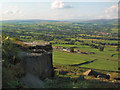
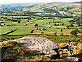
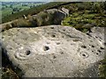
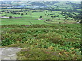
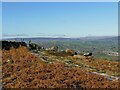
Rock ArtSite Name: Rock Art above Hardwick, Ilkley Alternative Name: Sepulchre Stone?Country: England County: Yorkshire (West) Type: Rock Art
Nearest Town: Ilkely
Map Ref: SE0839947108
Latitude: 53.920046N Longitude: 1.873603W
Condition:
| 5 | Perfect |
| 4 | Almost Perfect |
| 3 | Reasonable but with some damage |
| 2 | Ruined but still recognisable as an ancient site |
| 1 | Pretty much destroyed, possibly visible as crop marks |
| 0 | No data. |
| -1 | Completely destroyed |
| 5 | Superb |
| 4 | Good |
| 3 | Ordinary |
| 2 | Not Good |
| 1 | Awful |
| 0 | No data. |
| 5 | Can be driven to, probably with disabled access |
| 4 | Short walk on a footpath |
| 3 | Requiring a bit more of a walk |
| 2 | A long walk |
| 1 | In the middle of nowhere, a nightmare to find |
| 0 | No data. |
| 5 | co-ordinates taken by GPS or official recorded co-ordinates |
| 4 | co-ordinates scaled from a detailed map |
| 3 | co-ordinates scaled from a bad map |
| 2 | co-ordinates of the nearest village |
| 1 | co-ordinates of the nearest town |
| 0 | no data |
Internal Links:
External Links:
")
Cup and ring marks, one with two or ?three rings.
You may be viewing yesterday's version of this page. To see the most up to date information please register for a free account.
")
")
Do not use the above information on other web sites or publications without permission of the contributor.
Nearby Images from Geograph Britain and Ireland:
©2005(licence)
©2005(licence)
©2007(licence)
©2009(licence)
©2023(licence)
The above images may not be of the site on this page, they are loaded from Geograph.
Please Submit an Image of this site or go out and take one for us!
Click here to see more info for this site
Nearby sites
Key: Red: member's photo, Blue: 3rd party photo, Yellow: other image, Green: no photo - please go there and take one, Grey: site destroyed
Download sites to:
KML (Google Earth)
GPX (GPS waypoints)
CSV (Garmin/Navman)
CSV (Excel)
To unlock full downloads you need to sign up as a Contributory Member. Otherwise downloads are limited to 50 sites.
Turn off the page maps and other distractions
Nearby sites listing. In the following links * = Image available
91m E 95° Piper's Crag Stone* Rock Art (SE08494710)
95m E 93° Piper's Crag 02* Rock Art (SE0849447103)
222m NNW 336° Hardwick Holes 01* Rock Art (SE0830747310)
277m E 100° Piper's Crag 03.* Rock Art (SE0867347062)
278m E 99° Piper's Crag 03a* Rock Art (SE0867547067)
350m W 270° Noon Stone* Natural Stone / Erratic / Other Natural Feature (SE0804847106)
392m NE 54° Hardwick House 01* Rock Art (SE0871847337)
440m E 100° Piper's Crag 04* Rock Art (SE0883447035)
517m WNW 288° Addingham Crag 01a* Rock Art (SE0790547265)
548m WNW 287° Addingham Crag 01.* Rock Art (SE0787247265)
681m ESE 108° High Crag 01 (Ilkley)* Rock Art (SE0904946899)
682m E 99° Sepulchre Stone* Rock Art (SE0907547005)
712m ESE 102° Woodhouse Crag 01a* Rock Art (SE0909946966)
890m E 97° Anvil Rock* Rock Art (SE0928547000)
893m SW 236° Doubler Stones Allotment 04* Rock Art (SE0765546610)
976m SW 230° Doubler Stones Allotment 03* Rock Art (SE0765046480)
1.0km SSW 213° Black Pots 02* Rock Art (SE0782546233)
1.0km WSW 244° Doubler Stones Allotment 02* Rock Art (SE0745246655)
1.1km SW 214° Black Pots 01* Rock Art (SE0779946227)
1.1km E 97° Woodhouse Crag 03* Rock Art (SE0949646967)
1.2km E 97° Swastika Stone 01* Rock Art (SE0955446968)
1.2km WSW 243° Doubler Stones Allotment 01* Rock Art (SE0735346584)
1.3km WSW 243° Doubler Stones* Rock Art (SE0723046523)
1.4km SSW 205° High Moor 02 Rock Art (SE0779045800)
1.5km ESE 114° Black Beck Hole 01* Rock Art (SE0973246521)
View more nearby sites and additional images


 We would like to know more about this location. Please feel free to add a brief description and any relevant information in your own language.
 Wir möchten mehr über diese Stätte erfahren. Bitte zögern Sie nicht, eine kurze Beschreibung und relevante Informationen in Deutsch hinzuzufügen.
 Nous aimerions en savoir encore un peu sur les lieux. S'il vous plaît n'hesitez pas à ajouter une courte description et tous les renseignements pertinents dans votre propre langue.
 Quisieramos informarnos un poco más de las lugares. No dude en añadir una breve descripción y otros datos relevantes en su propio idioma.