 with our Megalithic Portal iPhone app")


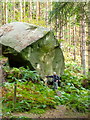
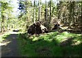
<< Our Photo Pages >> Hepburn Woods cist - Cist in England in Northumberland
Submitted by thecaptain on Friday, 30 October 2009 Page Views: 9386
Neolithic and Bronze AgeSite Name: Hepburn Woods cistCountry: England
NOTE: This site is 0.5 km away from the location you searched for.
County: Northumberland Type: Cist
Nearest Town: Alnwick Nearest Village: Chatton
Map Ref: NU073241
Latitude: 55.510613N Longitude: 1.885968W
Condition:
| 5 | Perfect |
| 4 | Almost Perfect |
| 3 | Reasonable but with some damage |
| 2 | Ruined but still recognisable as an ancient site |
| 1 | Pretty much destroyed, possibly visible as crop marks |
| 0 | No data. |
| -1 | Completely destroyed |
| 5 | Superb |
| 4 | Good |
| 3 | Ordinary |
| 2 | Not Good |
| 1 | Awful |
| 0 | No data. |
| 5 | Can be driven to, probably with disabled access |
| 4 | Short walk on a footpath |
| 3 | Requiring a bit more of a walk |
| 2 | A long walk |
| 1 | In the middle of nowhere, a nightmare to find |
| 0 | No data. |
| 5 | co-ordinates taken by GPS or official recorded co-ordinates |
| 4 | co-ordinates scaled from a detailed map |
| 3 | co-ordinates scaled from a bad map |
| 2 | co-ordinates of the nearest village |
| 1 | co-ordinates of the nearest town |
| 0 | no data |
Internal Links:
External Links:
I have visited· I would like to visit
imp would like to visit
")
You may be viewing yesterday's version of this page. To see the most up to date information please register for a free account.
")
")
Do not use the above information on other web sites or publications without permission of the contributor.
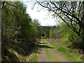
Nearby Images from Geograph Britain and Ireland:
©2015(licence)
©2015(licence)
©2010(licence)
©2015(licence)
©2015(licence)
The above images may not be of the site on this page, they are loaded from Geograph.
Please Submit an Image of this site or go out and take one for us!
Click here to see more info for this site
Nearby sites
Key: Red: member's photo, Blue: 3rd party photo, Yellow: other image, Green: no photo - please go there and take one, Grey: site destroyed
Download sites to:
KML (Google Earth)
GPX (GPS waypoints)
CSV (Garmin/Navman)
CSV (Excel)
To unlock full downloads you need to sign up as a Contributory Member. Otherwise downloads are limited to 50 sites.
Turn off the page maps and other distractions
Nearby sites listing. In the following links * = Image available
345m NW 313° Hepburn Moor a Rock Art (NU0704724336)
527m NE 51° Hepburn Moor Unenclosed 1 Rock Art (NU0771324429)
530m NE 48° Hepburn Moor Unenclosed 2 Rock Art (NU0769724453)
613m NNE 12° Hepburn Crags Camp Promontory Fort / Cliff Castle (NU07432470)
814m ENE 59° Hepburn Moor e Rock Art (NU0800024520)
873m ENE 63° Hepburn Moor 2 Rock Art (NU0807924499)
992m NE 45° Hepburn Moor 1 Rock Art (NU0799724808)
1.2km NE 35° Ros Castle 3 Rock Art (NU0798325062)
1.2km NE 36° Ros Castle 2* Rock Art (NU0799125070)
1.2km NE 35° Ros Castle 1* Rock Art (NU0799025071)
1.2km W 280° Hepburn Bell* Hillfort (NU06122431)
1.2km NE 36° Ros Castle 5 Rock Art (NU0800625072)
1.2km SE 134° Blawearie-Bewick Moor N01 Rock Art (NU0817923255)
1.2km NE 52° Ros Castle 6 Rock Art (NU0827624860)
1.2km NE 52° Ros Castle 7 Rock Art (NU0828024860)
1.3km SE 135° Blawearie-Bewick Moor N02 Rock Art (NU0824523159)
1.4km SE 136° Blawearie-Bewick Moor N03 Rock Art (NU0825223128)
1.5km NNE 33° Ros Castle hillfort* Hillfort (NU0810925342)
1.6km SE 125° Bewick Moor North b(i) Rock Art (NU0863323187)
1.7km SE 125° Bewick Moor North c Rock Art (NU0870623130)
2.0km SSE 154° Blawearie Cairn* Cairn (NU082223)
2.0km SSW 195° Holy Trinity (Old Bewick)* Ancient Cross (NU0679022152)
2.0km NNW 326° Hepburn Moor b & c Rock Art (NU0616925795)
2.2km SSE 167° Old Bewick 1i Rock Art (NU0779921946)
2.2km NE 53° Ox-Eye 1, 2 & 3 Rock Art (NU09062545)
View more nearby sites and additional images


 We would like to know more about this location. Please feel free to add a brief description and any relevant information in your own language.
 Wir möchten mehr über diese Stätte erfahren. Bitte zögern Sie nicht, eine kurze Beschreibung und relevante Informationen in Deutsch hinzuzufügen.
 Nous aimerions en savoir encore un peu sur les lieux. S'il vous plaît n'hesitez pas à ajouter une courte description et tous les renseignements pertinents dans votre propre langue.
 Quisieramos informarnos un poco más de las lugares. No dude en añadir una breve descripción y otros datos relevantes en su propio idioma.