 with our Megalithic Portal iPhone app")

<< Our Photo Pages >> Fox Covert Barrows - Barrow Cemetery in England in Wiltshire
Submitted by SolarMegalith on Monday, 22 January 2024 Page Views: 5627
Neolithic and Bronze AgeSite Name: Fox Covert BarrowsCountry: England County: Wiltshire Type: Barrow Cemetery
Map Ref: SU07536873
Latitude: 51.417537N Longitude: 1.893106W
Condition:
| 5 | Perfect |
| 4 | Almost Perfect |
| 3 | Reasonable but with some damage |
| 2 | Ruined but still recognisable as an ancient site |
| 1 | Pretty much destroyed, possibly visible as crop marks |
| 0 | No data. |
| -1 | Completely destroyed |
| 5 | Superb |
| 4 | Good |
| 3 | Ordinary |
| 2 | Not Good |
| 1 | Awful |
| 0 | No data. |
| 5 | Can be driven to, probably with disabled access |
| 4 | Short walk on a footpath |
| 3 | Requiring a bit more of a walk |
| 2 | A long walk |
| 1 | In the middle of nowhere, a nightmare to find |
| 0 | No data. |
| 5 | co-ordinates taken by GPS or official recorded co-ordinates |
| 4 | co-ordinates scaled from a detailed map |
| 3 | co-ordinates scaled from a bad map |
| 2 | co-ordinates of the nearest village |
| 1 | co-ordinates of the nearest town |
| 0 | no data |
Internal Links:
External Links:
I have visited· I would like to visit
SolarMegalith visited on 7th Jun 2012 - their rating: Cond: 3 Amb: 3 Access: 4
")
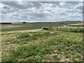
Avebury 10 bowl barrow is the most easterly located one, it is 2.0 m high.
Avebury 11 bowl barrow is a 1.2 m high ditch-less bowl barrow located between no 10. and 12.
Avebury 12 bowl barrow is the most westernly located barrow, it is 29 m in diameter and and 1.8 m high.
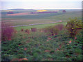
Avebury 13 saucer barrow has almost completely faded, it is only 0.4 m high.
Pastscape: Bronze Age round barrows near Fox Covert. (Grinsell's 10-13 and 16a). 10-12 are bowl barrows, and all are extant as earthwork mounds. 10 was excavated by Colt Hoare in the early 19th century, and contained a probable primary cremation. A Beaker sherd has also been recovered from the mound. 13 is a saucer barrow. 16a is a barrow excavated by Merewether in 1849, and which produced a decorated urn. The precise location of the barrow is uncertain but it is thought to have been close to this group.
Source: Pastscape
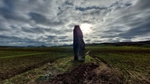
Note: A lovely example of a saucer barrow, "Avebury 13", only 0.4m high
You may be viewing yesterday's version of this page. To see the most up to date information please register for a free account.
")
")
")
")
Do not use the above information on other web sites or publications without permission of the contributor.
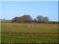
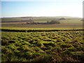
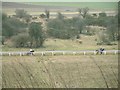
Nearby Images from Geograph Britain and Ireland:
©2017(licence)
©2014(licence)
©2006(licence)
©2022(licence)
©2010(licence)
The above images may not be of the site on this page, they are loaded from Geograph.
Please Submit an Image of this site or go out and take one for us!
Click here to see more info for this site
Nearby sites
Key: Red: member's photo, Blue: 3rd party photo, Yellow: other image, Green: no photo - please go there and take one, Grey: site destroyed
Download sites to:
KML (Google Earth)
GPX (GPS waypoints)
CSV (Garmin/Navman)
CSV (Excel)
To unlock full downloads you need to sign up as a Contributory Member. Otherwise downloads are limited to 50 sites.
Turn off the page maps and other distractions
Nearby sites listing. In the following links * = Image available
169m SW 225° Fox Covert Bowl Barrows Barrow Cemetery (SU07416861)
322m SE 144° Beckhampton Bowl Barrow Round Barrow(s) (SU07726847)
562m NNW 331° Knoll Down Barrows* Barrow Cemetery (SU0725369219)
636m SW 228° Henge and Four Bronze Age Barrows South West of Fox Covert* Barrow Cemetery (SU07066830)
898m SSW 197° Beckhampton Firs Barrows* Barrow Cemetery (SU07276787)
977m NE 56° North of The Grange Round Barrow(s) (SU08346928)
1.0km SSE 162° Bishops Cannings 89 Bowl Barrow* Round Barrow(s) (SU0785467757)
1.1km SSE 158° Bishops Cannings 88 Bell Barrow* Round Barrow(s) (SU0793367741)
1.1km ENE 64° South of Penning Barn* Round Barrow(s) (SU08506921)
1.1km SW 229° Bishops Cannings 26 Bell Barrow* Round Barrow(s) (SU0671268009)
1.2km NW 319° Old Bath Road Tumulus* Round Barrow(s) (SU06746963)
1.2km ENE 71° Longstones Barrow* Long Barrow (SU08706914)
1.3km SW 216° Beckhampton Firs Long Barrow* Long Barrow (SU0678267707)
1.3km SW 217° Beckhampton Buildings Barrows Round Barrow(s) (SU06736766)
1.4km NNW 339° Cherhill Cursus Cursus (SU07057000)
1.4km SSW 210° Beckhampton Firs Tumulus* Round Barrow(s) (SU06846754)
1.5km ENE 67° Longstone Cove* Standing Stones (SU0888769301)
1.6km ENE 70° South Street Long Barrow* Chambered Tomb (SU09006927)
1.6km SW 228° Down Barn Tumuli* Round Barrow(s) (SU06366766)
1.6km S 182° Hemp Knoll Enclosures 2 Misc. Earthwork (SU07496713)
1.6km WSW 259° Beckhampton (Avebury 6) Round Barrow(s) (SU05936841)
1.7km SSW 201° Beckhampton Buildings Enclosure 1 Misc. Earthwork (SU06936714)
1.9km WSW 246° North Down Tumulus Round Barrow(s) (SU05836797)
1.9km SSW 205° Beckhampton Buildings Enclosure 2 Misc. Earthwork (SU06756702)
1.9km S 186° Hemp Knoll Enclosures 1 Misc. Earthwork (SU07326682)
View more nearby sites and additional images


 We would like to know more about this location. Please feel free to add a brief description and any relevant information in your own language.
 Wir möchten mehr über diese Stätte erfahren. Bitte zögern Sie nicht, eine kurze Beschreibung und relevante Informationen in Deutsch hinzuzufügen.
 Nous aimerions en savoir encore un peu sur les lieux. S'il vous plaît n'hesitez pas à ajouter une courte description et tous les renseignements pertinents dans votre propre langue.
 Quisieramos informarnos un poco más de las lugares. No dude en añadir una breve descripción y otros datos relevantes en su propio idioma.