


<< Our Photo Pages >> Barningham Moor 60 - Rock Art in England in County Durham
Submitted by SolarMegalith on Friday, 21 December 2012 Page Views: 1827
Rock ArtSite Name: Barningham Moor 60 Alternative Name: Barningham Moor 81 (Beckensall & Laurie), BAR 34 (P&B Brown); ERA-859; SAM 30479; SMR/HER D5713Country: England
NOTE: This site is 0.2 km away from the location you searched for.
County: County Durham Type: Rock Art
Nearest Town: Barnard Castle Nearest Village: Barningham
Map Ref: NZ0520607422
Latitude: 54.462151N Longitude: 1.921199W
Condition:
| 5 | Perfect |
| 4 | Almost Perfect |
| 3 | Reasonable but with some damage |
| 2 | Ruined but still recognisable as an ancient site |
| 1 | Pretty much destroyed, possibly visible as crop marks |
| 0 | No data. |
| -1 | Completely destroyed |
| 5 | Superb |
| 4 | Good |
| 3 | Ordinary |
| 2 | Not Good |
| 1 | Awful |
| 0 | No data. |
| 5 | Can be driven to, probably with disabled access |
| 4 | Short walk on a footpath |
| 3 | Requiring a bit more of a walk |
| 2 | A long walk |
| 1 | In the middle of nowhere, a nightmare to find |
| 0 | No data. |
| 5 | co-ordinates taken by GPS or official recorded co-ordinates |
| 4 | co-ordinates scaled from a detailed map |
| 3 | co-ordinates scaled from a bad map |
| 2 | co-ordinates of the nearest village |
| 1 | co-ordinates of the nearest town |
| 0 | no data |
Internal Links:
External Links:
I have visited· I would like to visit
SolarMegalith visited on 8th Oct 2013 - their rating: Cond: 4 Amb: 4 Access: 3
")
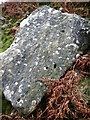
This moved boulder with nine deep cup-marks is part of a burial cairn. Referred to as Barningham Moor 81 by Beckensall and Laurie (1998) and as BAR 34 by P. and B. Brown (2008).
Reference:
Brown, P. and B. 2008. "Prehistoric Rock Art in the Northern Dales". Stroud: Tempus, p. 264 (as BAR 34).
This rock art panel is also recorded as England's Rock Art entry for ERA-859 Barningham Moor 60, which includes NADRAP's notes, photographs, a sketch of the rock and its motifs, plus photogrammetry.
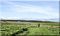
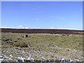
It is not recorded if this rock art panel is located on Open Access or private land; land usage given is 'heathland/moorland'.
You may be viewing yesterday's version of this page. To see the most up to date information please register for a free account.
")
Do not use the above information on other web sites or publications without permission of the contributor.
Nearby Images from Geograph Britain and Ireland:
©2023(licence)
©2022(licence)

©2022(licence)
©2006(licence)
©2010(licence)
The above images may not be of the site on this page, they are loaded from Geograph.
Please Submit an Image of this site or go out and take one for us!
Click here to see more info for this site
Nearby sites
Key: Red: member's photo, Blue: 3rd party photo, Yellow: other image, Green: no photo - please go there and take one, Grey: site destroyed
Download sites to:
KML (Google Earth)
GPX (GPS waypoints)
CSV (Garmin/Navman)
CSV (Excel)
To unlock full downloads you need to sign up as a Contributory Member. Otherwise downloads are limited to 50 sites.
Turn off the page maps and other distractions
Nearby sites listing. In the following links * = Image available
140m NNW 336° How Tallon Stone Circle* Stone Circle (NZ05150755)
202m N 4° Barningham Moor 59* Rock Art (NZ0522007624)
251m N 6° Barningham Moor 58* Rock Art (NZ0523207672)
317m NNE 25° Barningham Moor 89 Rock Art (NZ0534107709)
363m NE 41° Barningham Moor 81 Rock Art (NZ0544307698)
371m NNE 31° Barningham Moor 88 Rock Art (NZ0539707741)
376m NE 41° Barningham Moor 80 Rock Art (NZ0545107708)
377m N 4° Eel Hill Cairn* Cairn (NZ0523307798)
382m NE 44° Barningham Moor 77 Rock Art (NZ0547407695)
385m NE 41° Barningham Moor 79 Rock Art (NZ0545807714)
389m NE 44° Barningham Moor 78 Rock Art (NZ0547507704)
391m NE 45° Barningham Moor 122 Rock Art (NZ0548507697)
391m NE 47° Barningham Moor 118 Rock Art (NZ0549207690)
391m N 349° Barningham Moor 57* Rock Art (NZ0512907806)
393m NE 45° Barningham Moor 117 Rock Art (NZ0548307702)
394m NE 45° Barningham Moor 76 Rock Art (NZ0548507701)
395m NE 45° Barningham Moor 148 Rock Art (NZ0548707701)
397m NE 39° Barningham Moor 82 Rock Art (NZ0545707731)
403m NE 39° Barningham Moor 83 Rock Art (NZ0546107735)
405m NE 36° Barningham Moor 84 Rock Art (NZ0544207752)
406m NE 50° Barningham Moor 95 Rock Art (NZ0551607685)
406m NE 35° Barningham Moor 85 Rock Art (NZ0544207753)
407m NE 45° Barningham Moor 134 Rock Art (NZ0549307712)
409m NE 36° Barningham Moor 86 Rock Art (NZ0544407755)
415m NE 50° Barningham Moor 74 Rock Art (NZ0552607687)
View more nearby sites and additional images


 We would like to know more about this location. Please feel free to add a brief description and any relevant information in your own language.
 Wir möchten mehr über diese Stätte erfahren. Bitte zögern Sie nicht, eine kurze Beschreibung und relevante Informationen in Deutsch hinzuzufügen.
 Nous aimerions en savoir encore un peu sur les lieux. S'il vous plaît n'hesitez pas à ajouter une courte description et tous les renseignements pertinents dans votre propre langue.
 Quisieramos informarnos un poco más de las lugares. No dude en añadir una breve descripción y otros datos relevantes en su propio idioma.