


<< Our Photo Pages >> West Shank Enclosure - Misc. Earthwork in England in Northumberland
Submitted by Anne T on Monday, 20 July 2015 Page Views: 1785
Multi-periodSite Name: West Shank EnclosureCountry: England County: Northumberland Type: Misc. Earthwork
Nearest Town: Morpeth Nearest Village: Scot's Gap
Map Ref: NZ02269364
Latitude: 55.236959N Longitude: 1.966005W
Condition:
| 5 | Perfect |
| 4 | Almost Perfect |
| 3 | Reasonable but with some damage |
| 2 | Ruined but still recognisable as an ancient site |
| 1 | Pretty much destroyed, possibly visible as crop marks |
| 0 | No data. |
| -1 | Completely destroyed |
| 5 | Superb |
| 4 | Good |
| 3 | Ordinary |
| 2 | Not Good |
| 1 | Awful |
| 0 | No data. |
| 5 | Can be driven to, probably with disabled access |
| 4 | Short walk on a footpath |
| 3 | Requiring a bit more of a walk |
| 2 | A long walk |
| 1 | In the middle of nowhere, a nightmare to find |
| 0 | No data. |
| 5 | co-ordinates taken by GPS or official recorded co-ordinates |
| 4 | co-ordinates scaled from a detailed map |
| 3 | co-ordinates scaled from a bad map |
| 2 | co-ordinates of the nearest village |
| 1 | co-ordinates of the nearest town |
| 0 | no data |
Internal Links:
External Links:
I have visited· I would like to visit
Anne T visited on 15th Jul 2015 - their rating: Cond: 2 Amb: 3 Access: 3 West Shank Enclosure, near Fontburn Reservoir, Northumberland: See visit report for Hollinghill Enclosure.
")
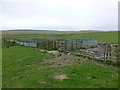
Lying almost due south of the remote Fallowlees Farm across the Fallowlees Burn to the north, this enclosure is formed by very obvious low banks to its northern edge, together with an outer ditch. It has partly been destroyed by modern pathways.
The enclosure has a polygonal shape rather than rectangular or oval in shape and is cut not only by the footpath but by a modern farmtrack with runs on a north west slope down to Fallowlees Burn. It encloses an area approximately 85 metres by 70 metres.
From Hollinghill Enclosure, follow the footpath westwards for about 200 yards, across ground which has clear ridge and furrow marks.
The enclosure, together with Hollinghill Enclosure to its east, can be seen clearly on Google Earth.
You may be viewing yesterday's version of this page. To see the most up to date information please register for a free account.
")
Do not use the above information on other web sites or publications without permission of the contributor.
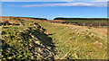
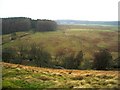
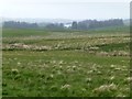
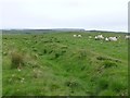
Nearby Images from Geograph Britain and Ireland:
©2024(licence)
©2009(licence)
©2016(licence)
©2016(licence)
©2016(licence)
The above images may not be of the site on this page, they are loaded from Geograph.
Please Submit an Image of this site or go out and take one for us!
Click here to see more info for this site
Nearby sites
Key: Red: member's photo, Blue: 3rd party photo, Yellow: other image, Green: no photo - please go there and take one, Grey: site destroyed
Download sites to:
KML (Google Earth)
GPX (GPS waypoints)
CSV (Garmin/Navman)
CSV (Excel)
To unlock full downloads you need to sign up as a Contributory Member. Otherwise downloads are limited to 50 sites.
Turn off the page maps and other distractions
Nearby sites listing. In the following links * = Image available
150m N 350° Fontburn a(i)* Rock Art (NZ0223593788)
155m NNW 348° Fontburn a(ii)* Rock Art (NZ0222793792)
169m NW 323° Fontburn a(iii)* Rock Art (NZ0215893775)
182m NW 316° Fontburn (iv) Rock Art (NZ0213493772)
332m NNW 327° Fallowlees Burn Stone Rock Art (NZ0208093920)
350m W 275° Fallowlees Settlement* Ancient Village or Settlement (NZ01919367)
369m W 268° Fontburn a(v) Rock Art (NZ0189093629)
406m W 270° Fontburn a(vi)* Rock Art (NZ0185393643)
406m W 271° Fontburn a(vii)* Rock Art (NZ0185393645)
406m W 271° Fontburn a(viii)* Rock Art (NZ0185393645)
441m E 85° Hollinghill Enclosure* Misc. Earthwork (NZ02709368)
855m E 98° Fontburn D* Rock Art (NZ0310993518)
941m ESE 104° Fontburn N03 Rock Art (NZ0317793419)
991m E 90° Fontburn Four-Poster* Stone Circle (NZ0325493646)
993m E 89° Fontburn c(ii) Rock Art (NZ0325693650)
1.1km ESE 105° Fontburn B* Rock Art (NZ0328093376)
1.1km ENE 75° Fontburn e Rock Art (NZ0336593941)
1.8km ESE 105° Fontburn N02* Rock Art (NZ0395993186)
2.6km E 94° Fontburn N01 Rock Art (NZ0489793466)
3.7km ESE 105° Ewesley Enclosure* Misc. Earthwork (NZ0583092681)
4.8km N 9° Old Stell Crag* Rock Outcrop (NZ0297498372)
4.9km N 5° Simonside Cairn 1* Cairn (NZ0271098520)
5.1km N 2° Simonside Cairn 2* Cairn (NZ02409871)
5.1km NNE 17° Dove Crag Cairn* Cairn (NZ0372898523)
5.1km NNE 16° Dove Crag* Rock Outcrop (NZ0367898540)
View more nearby sites and additional images


 We would like to know more about this location. Please feel free to add a brief description and any relevant information in your own language.
 Wir möchten mehr über diese Stätte erfahren. Bitte zögern Sie nicht, eine kurze Beschreibung und relevante Informationen in Deutsch hinzuzufügen.
 Nous aimerions en savoir encore un peu sur les lieux. S'il vous plaît n'hesitez pas à ajouter une courte description et tous les renseignements pertinents dans votre propre langue.
 Quisieramos informarnos un poco más de las lugares. No dude en añadir una breve descripción y otros datos relevantes en su propio idioma.