


<< Our Photo Pages >> The Fishing Barrow - Round Barrow(s) in England in Dorset
Submitted by JimChampion on Tuesday, 28 August 2012 Page Views: 3675
Neolithic and Bronze AgeSite Name: The Fishing BarrowCountry: England County: Dorset Type: Round Barrow(s)
Nearest Town: Swanage Nearest Village: Studland
Map Ref: SZ01818210
Latitude: 50.638589N Longitude: 1.975766W
Condition:
| 5 | Perfect |
| 4 | Almost Perfect |
| 3 | Reasonable but with some damage |
| 2 | Ruined but still recognisable as an ancient site |
| 1 | Pretty much destroyed, possibly visible as crop marks |
| 0 | No data. |
| -1 | Completely destroyed |
| 5 | Superb |
| 4 | Good |
| 3 | Ordinary |
| 2 | Not Good |
| 1 | Awful |
| 0 | No data. |
| 5 | Can be driven to, probably with disabled access |
| 4 | Short walk on a footpath |
| 3 | Requiring a bit more of a walk |
| 2 | A long walk |
| 1 | In the middle of nowhere, a nightmare to find |
| 0 | No data. |
| 5 | co-ordinates taken by GPS or official recorded co-ordinates |
| 4 | co-ordinates scaled from a detailed map |
| 3 | co-ordinates scaled from a bad map |
| 2 | co-ordinates of the nearest village |
| 1 | co-ordinates of the nearest town |
| 0 | no data |
Internal Links:
External Links:
I have visited· I would like to visit
Ogham visited on 6th Oct 2007 - their rating: Cond: 3 Amb: 4 Access: 3
")
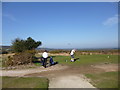
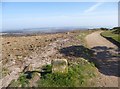
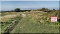
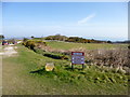
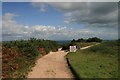
Bell barrow on Godlingston Heath.
The barrow is alongside a footpath through the Isle of Purbeck Golf Course, and it has been landscaped as part of the golf course giving it a very flat top. The monument's scheduling excludes 'the bench and golf ball washing facility situated on the north-east side of the mound'.
Situated high on Godlingston Heath, there are spectacular views from the barrow across Studland Heath and Poole Harbour.
You may be viewing yesterday's version of this page. To see the most up to date information please register for a free account.
")
")
")
")
Do not use the above information on other web sites or publications without permission of the contributor.
Nearby Images from Geograph Britain and Ireland:
©2012(licence)
©2012(licence)
©2021(licence)
©2012(licence)
©2017(licence)
The above images may not be of the site on this page, they are loaded from Geograph.
Please Submit an Image of this site or go out and take one for us!
Click here to see more info for this site
Nearby sites
Key: Red: member's photo, Blue: 3rd party photo, Yellow: other image, Green: no photo - please go there and take one, Grey: site destroyed
Download sites to:
KML (Google Earth)
GPX (GPS waypoints)
CSV (Garmin/Navman)
CSV (Excel)
To unlock full downloads you need to sign up as a Contributory Member. Otherwise downloads are limited to 50 sites.
Turn off the page maps and other distractions
Nearby sites listing. In the following links * = Image available
890m SSE 153° The Ulwell Barrow* Round Barrow(s) (SZ02228131)
911m NE 37° Agglestone* Natural Stone / Erratic / Other Natural Feature (SZ0236182826)
1.0km NNE 16° Puckstone* Natural Stone / Erratic / Other Natural Feature (SZ021831)
2.3km ESE 110° Ballard Down* Round Barrow(s) (SZ03988130)
2.3km W 270° Rempstone* Stone Circle (SY99468208)
2.4km WSW 258° Nine Barrow Down* Barrow Cemetery (SY995816)
2.8km E 92° The King Barrow (Isle of Purbeck)* Round Barrow(s) (SZ04618201)
3.3km NNE 14° Studland* Stone Row / Alignment (SZ026853)
5.4km W 273° Corfe Castle East Hill barrows* Round Barrow(s) (SY96388237)
5.8km WSW 258° Corfe Common* Barrow Cemetery (SY961809)
5.8km W 272° Corfe Castle & St. Edward the Martyr's Well* Holy Well or Sacred Spring (SY9595082317)
5.9km WSW 236° Afflington Barrow* Round Barrow(s) (SY96867880)
6.3km W 272° Corfe Castle West Hill barrows* Round Barrow(s) (SY95478237)
7.2km W 272° Knowle Hill Barrows* Round Barrow(s) (SY94578233)
7.4km W 272° Knowle Hill Cross Dyke* Misc. Earthwork (SY94398237)
8.2km WNW 286° Three Barrows (Furzebrook)* Barrow Cemetery (SY939844)
8.8km NW 322° Conygar Hill Timber Circle Timber Circle (SY964891)
9.1km WSW 246° Swyre Head* Round Barrow(s) (SY93417845)
9.7km W 261° The Harp Stone* Standing Stone (Menhir) (SY92168058)
10.3km WNW 284° Creech Bottom Standing Stones (SY918846)
10.6km NNE 18° Parkstone Standing Stone (Menhir) (SZ050922)
10.6km WNW 299° Lady St Mary (Wareham)* Ancient Cross (SY92498719)
10.7km WNW 284° Three Lord's Round Barrow(s) (SY914847)
11.1km WNW 300° Wareham Walls* Misc. Earthwork (SY92218771)
11.2km W 278° Grange Heath Bell Barrow Round Barrow(s) (SY90658374)
View more nearby sites and additional images


 We would like to know more about this location. Please feel free to add a brief description and any relevant information in your own language.
 Wir möchten mehr über diese Stätte erfahren. Bitte zögern Sie nicht, eine kurze Beschreibung und relevante Informationen in Deutsch hinzuzufügen.
 Nous aimerions en savoir encore un peu sur les lieux. S'il vous plaît n'hesitez pas à ajouter une courte description et tous les renseignements pertinents dans votre propre langue.
 Quisieramos informarnos un poco más de las lugares. No dude en añadir una breve descripción y otros datos relevantes en su propio idioma.