


<< Our Photo Pages >> Scrubbity Barrows - Barrow Cemetery in England in Dorset
Submitted by h_fenton on Saturday, 15 December 2007 Page Views: 6191
Neolithic and Bronze AgeSite Name: Scrubbity BarrowsCountry: England County: Dorset Type: Barrow Cemetery
Nearest Village: Sixpenny Handley
Map Ref: ST97201789
Latitude: 50.960428N Longitude: 2.041241W
Condition:
| 5 | Perfect |
| 4 | Almost Perfect |
| 3 | Reasonable but with some damage |
| 2 | Ruined but still recognisable as an ancient site |
| 1 | Pretty much destroyed, possibly visible as crop marks |
| 0 | No data. |
| -1 | Completely destroyed |
| 5 | Superb |
| 4 | Good |
| 3 | Ordinary |
| 2 | Not Good |
| 1 | Awful |
| 0 | No data. |
| 5 | Can be driven to, probably with disabled access |
| 4 | Short walk on a footpath |
| 3 | Requiring a bit more of a walk |
| 2 | A long walk |
| 1 | In the middle of nowhere, a nightmare to find |
| 0 | No data. |
| 5 | co-ordinates taken by GPS or official recorded co-ordinates |
| 4 | co-ordinates scaled from a detailed map |
| 3 | co-ordinates scaled from a bad map |
| 2 | co-ordinates of the nearest village |
| 1 | co-ordinates of the nearest town |
| 0 | no data |
Internal Links:
External Links:
I have visited· I would like to visit
JimChampion h_fenton have visited here
")
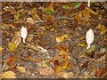
There are eight bowl barrows to found in this barrow cemetery. These were partially excavated in the 1880s by Pitt-Rivers. Barrow diameters range from 5m to 20m, barrow heights range from 0.5m to 1.8m.
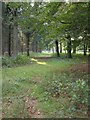
Located in woodland, alongside a public footpath
You may be viewing yesterday's version of this page. To see the most up to date information please register for a free account.
")
")
Do not use the above information on other web sites or publications without permission of the contributor.
Nearby Images from Geograph Britain and Ireland:
©2006(licence)
©2006(licence)
©2006(licence)
©2006(licence)
©2006(licence)
The above images may not be of the site on this page, they are loaded from Geograph.
Please Submit an Image of this site or go out and take one for us!
Click here to see more info for this site
Nearby sites
Key: Red: member's photo, Blue: 3rd party photo, Yellow: other image, Green: no photo - please go there and take one, Grey: site destroyed
Download sites to:
KML (Google Earth)
GPX (GPS waypoints)
CSV (Garmin/Navman)
CSV (Excel)
To unlock full downloads you need to sign up as a Contributory Member. Otherwise downloads are limited to 50 sites.
Turn off the page maps and other distractions
Nearby sites listing. In the following links * = Image available
2.9km NE 56° Mistlebury* Hillfort (ST99581948)
3.7km NNE 15° South Down Ox Drove Tumuli* Round Barrow(s) (ST982215)
4.1km E 98° Wor Barrow* Long Barrow (SU01241729)
4.3km SE 127° Wyke Down henge* Henge (SU006153)
4.3km SSE 155° Gussage Hill Ancient Village or Settlement (ST990140)
4.4km NNW 333° Winklebury Camp (Wiltshire) Hillfort (ST952218)
4.5km ESE 111° Bottlebush Down barrows* Barrow Cemetery (SU01381625)
4.5km ENE 63° Bokerley Dyke Misc. Earthwork (SU01241990)
4.6km SE 126° Wyke Down barrows* Round Barrow(s) (SU009152)
4.6km SSE 153° Gussage Down (North)* Long Barrow (ST993138)
4.6km E 97° Oakley Down Barrows* Barrow Cemetery (SU01821731)
4.8km WSW 241° Caesar's Camp (Dorset)* Hillfort (ST930156)
4.8km SSE 153° Gussage Down (South)* Long Barrow (ST994136)
4.9km S 189° Thickthorn Farm Long Barrow (ST964131)
4.9km ESE 118° Pentridge Cursus Cursus (SU015156)
4.9km ESE 118° Gussage St Michael Cursus Cursus (SU015156)
4.9km ESE 113° Dorset Cursus* Cursus (SU01751600)
5.0km S 181° Ogden Down 3 Timber Circle (ST971129)
5.2km SSE 157° Gussage South-East Long Barrow (ST992131)
5.3km SE 127° Drive Plantation* Long Barrow (SU014147)
5.4km E 101° Pentridge 4* Long Barrow (SU025169)
5.5km S 183° Gussage St Michael Cursus Cursus (ST969124)
5.5km SSW 203° Chettle House* Long Barrow (ST9506612803)
5.6km S 182° Thickthorn Down (North)* Long Barrow (ST970123)
5.6km SW 218° Chettle Long Barrow* Long Barrow (ST937135)
View more nearby sites and additional images


 We would like to know more about this location. Please feel free to add a brief description and any relevant information in your own language.
 Wir möchten mehr über diese Stätte erfahren. Bitte zögern Sie nicht, eine kurze Beschreibung und relevante Informationen in Deutsch hinzuzufügen.
 Nous aimerions en savoir encore un peu sur les lieux. S'il vous plaît n'hesitez pas à ajouter une courte description et tous les renseignements pertinents dans votre propre langue.
 Quisieramos informarnos un poco más de las lugares. No dude en añadir una breve descripción y otros datos relevantes en su propio idioma.