 with our Megalithic Portal iPhone app")

, Aubrey Burl")
<< Our Photo Pages >> Cat Cairn - Cairn in Scotland in Aberdeenshire
Submitted by vicky on Monday, 26 August 2002 Page Views: 9634
Neolithic and Bronze AgeSite Name: Cat CairnCountry: Scotland County: Aberdeenshire Type: Cairn
Map Ref: NJ952031 Landranger Map Number: 38
Latitude: 57.118814N Longitude: 2.0809W
Condition:
| 5 | Perfect |
| 4 | Almost Perfect |
| 3 | Reasonable but with some damage |
| 2 | Ruined but still recognisable as an ancient site |
| 1 | Pretty much destroyed, possibly visible as crop marks |
| 0 | No data. |
| -1 | Completely destroyed |
| 5 | Superb |
| 4 | Good |
| 3 | Ordinary |
| 2 | Not Good |
| 1 | Awful |
| 0 | No data. |
| 5 | Can be driven to, probably with disabled access |
| 4 | Short walk on a footpath |
| 3 | Requiring a bit more of a walk |
| 2 | A long walk |
| 1 | In the middle of nowhere, a nightmare to find |
| 0 | No data. |
| 5 | co-ordinates taken by GPS or official recorded co-ordinates |
| 4 | co-ordinates scaled from a detailed map |
| 3 | co-ordinates scaled from a bad map |
| 2 | co-ordinates of the nearest village |
| 1 | co-ordinates of the nearest town |
| 0 | no data |
Internal Links:
External Links:
I have visited· I would like to visit
SolarMegalith visited on 21st Sep 2018 - their rating: Cond: 3 Amb: 4 Access: 4
megalithicmatt visited on 2nd Apr 2011 - their rating: Cond: 3 Amb: 3 Access: 3 The easiest one to reach from the town.
Average ratings for this site from all visit loggers: Condition: 3 Ambience: 3.5 Access: 3.5
")
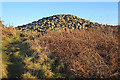
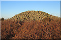
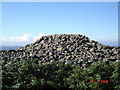
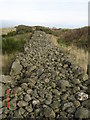
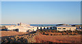
Cat Cairn is the best preserved among the four Bronze Age cairns at Tullos Hill.
You may be viewing yesterday's version of this page. To see the most up to date information please register for a free account.
")
")
")
")
Do not use the above information on other web sites or publications without permission of the contributor.
Nearby Images from Geograph Britain and Ireland:
©2018(licence)
©2018(licence)
©2006(licence)
©2006(licence)
©2018(licence)
The above images may not be of the site on this page, they are loaded from Geograph.
Please Submit an Image of this site or go out and take one for us!
Click here to see more info for this site
Nearby sites
Key: Red: member's photo, Blue: 3rd party photo, Yellow: other image, Green: no photo - please go there and take one, Grey: site destroyed
Download sites to:
KML (Google Earth)
GPX (GPS waypoints)
CSV (Garmin/Navman)
CSV (Excel)
To unlock full downloads you need to sign up as a Contributory Member. Otherwise downloads are limited to 50 sites.
Turn off the page maps and other distractions
Nearby sites listing. In the following links * = Image available
360m NNW 326° Tullos Hut Circles* Ancient Village or Settlement (NJ950034)
847m NE 45° Baron's Cairn* Cairn (NJ958037)
1.2km NE 35° Tullos Cairn* Cairn (NJ959041)
1.2km ENE 61° Crab's Cairn* Cairn (NJ963037)
3.2km NNW 333° The Langstane* Standing Stone (Menhir) (NJ93770597)
3.3km NNW 344° Marischal Museum* Museum (NJ943063)
3.3km WSW 257° Tollohill* Ring Cairn (NJ91950235)
3.5km NNW 345° Tillytarmont 1* Class I Pictish Symbol Stone (NJ94280651)
3.8km WSW 258° Dunnicaer 1* Class I Pictish Symbol Stone (NJ91500232)
5.3km NNW 346° King's Museum* Museum (NJ9391608216)
5.8km W 274° Friarsfield* Stone Circle (NJ894035)
6.0km NNW 330° Lang Stane (Aberdeen)* Standing Stone (Menhir) (NJ922083)
6.7km SW 217° Craighead Badentoy* Stone Circle (NO91189772)
6.8km W 267° Bieldside* Cairn (NJ88340280)
7.2km SW 219° Cairnwell* Stone Circle (NO90649750)
8.4km SW 216° Auchquhorthies* Stone Circle (NO90199634)
8.5km SW 224° Auchlee Cairn* Ring Cairn (NO893970)
8.5km SW 214° Old Bourtreebush* Stone Circle (NO9036096083)
8.7km SW 225° Auchlee Circle* Stone Circle (NO890969)
9.0km SSW 211° Hilton of Cairngrassie* Standing Stone (Menhir) (NO90589531)
9.4km W 279° Blacktop* Rock Art (NJ85900455)
9.5km NNW 340° Whitestripes Henge (NJ919120)
9.6km SW 232° Craigentath Ancient Village or Settlement (NO876972)
9.7km W 266° Binghill* Stone Circle (NJ85520237)
10.1km N 353° Dubford Standing Stone (Menhir) (NJ9400313096)
View more nearby sites and additional images


 We would like to know more about this location. Please feel free to add a brief description and any relevant information in your own language.
 Wir möchten mehr über diese Stätte erfahren. Bitte zögern Sie nicht, eine kurze Beschreibung und relevante Informationen in Deutsch hinzuzufügen.
 Nous aimerions en savoir encore un peu sur les lieux. S'il vous plaît n'hesitez pas à ajouter une courte description et tous les renseignements pertinents dans votre propre langue.
 Quisieramos informarnos un poco más de las lugares. No dude en añadir una breve descripción y otros datos relevantes en su propio idioma.