


<< Our Photo Pages >> Dove Stones (Widdop Moor) - Natural Stone / Erratic / Other Natural Feature in England in Yorkshire (West)
Submitted by Anne T on Sunday, 06 August 2017 Page Views: 2284
Natural PlacesSite Name: Dove Stones (Widdop Moor) Alternative Name: Dew StonesCountry: England County: Yorkshire (West) Type: Natural Stone / Erratic / Other Natural Feature
Nearest Town: Burnley Nearest Village: Widdop
Map Ref: SD93333479
Latitude: 53.809356N Longitude: 2.102772W
Condition:
| 5 | Perfect |
| 4 | Almost Perfect |
| 3 | Reasonable but with some damage |
| 2 | Ruined but still recognisable as an ancient site |
| 1 | Pretty much destroyed, possibly visible as crop marks |
| 0 | No data. |
| -1 | Completely destroyed |
| 5 | Superb |
| 4 | Good |
| 3 | Ordinary |
| 2 | Not Good |
| 1 | Awful |
| 0 | No data. |
| 5 | Can be driven to, probably with disabled access |
| 4 | Short walk on a footpath |
| 3 | Requiring a bit more of a walk |
| 2 | A long walk |
| 1 | In the middle of nowhere, a nightmare to find |
| 0 | No data. |
| 5 | co-ordinates taken by GPS or official recorded co-ordinates |
| 4 | co-ordinates scaled from a detailed map |
| 3 | co-ordinates scaled from a bad map |
| 2 | co-ordinates of the nearest village |
| 1 | co-ordinates of the nearest town |
| 0 | no data |
Be the first person to rate this site - see the 'Contribute!' box in the right hand menu.
Internal Links:
External Links:
 (PID:183700)")
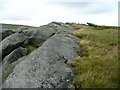
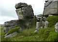
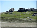
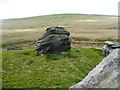
This rock formation is described as "the only feature on the otherwise open moor, and all the more interesting for that" on Walking World.
The Northern Antiquarian (TNA) also features a page on these legendary stones - see their page for Dove Stones, Widdop Moor, West Yorkshire which gives directions for finding the outcropt together with a brief archaeology & history and local folklore. TNA tell us that Harland and Wilkinson, folklorists, included these stones in their survey of druidical sites (1882) and include the location of the Dove Stones on an 1848 map.
Note: Have you visited this site? Do you have any photographs or further information you can add?
You may be viewing yesterday's version of this page. To see the most up to date information please register for a free account.
Do not use the above information on other web sites or publications without permission of the contributor.
Nearby Images from Geograph Britain and Ireland:
©2019(licence)
©2019(licence)
©2019(licence)
©2017(licence)
©2019(licence)
The above images may not be of the site on this page, they are loaded from Geograph.
Please Submit an Image of this site or go out and take one for us!
Click here to see more info for this site
Nearby sites
Key: Red: member's photo, Blue: 3rd party photo, Yellow: other image, Green: no photo - please go there and take one, Grey: site destroyed
Download sites to:
KML (Google Earth)
GPX (GPS waypoints)
CSV (Garmin/Navman)
CSV (Excel)
To unlock full downloads you need to sign up as a Contributory Member. Otherwise downloads are limited to 50 sites.
Turn off the page maps and other distractions
Nearby sites listing. In the following links * = Image available
1.3km SW 216° Grey Stone Hill* Rock Art (SD9259433766)
1.6km NNE 24° Boulsworth Hill Carvings* Carving (SD9397836237)
1.7km SSW 197° Widdop Rock Art (SD9282633159)
2.2km SE 142° Pisser Rough (North) Standing Stones (SD9469233048)
2.3km SSE 161° The Notch* Standing Stones (SD94093262)
2.3km SE 146° Sutcliffe Rough Standing Stone (Menhir) (SD9461132872)
3.0km ESE 107° Shaw Dyke Hill* Standing Stones (SD96223388)
3.1km W 278° Broadbank* Ancient Village or Settlement (SD9023935227)
3.1km NNE 13° Brink Ends Cairn Cairn (SD94033786)
3.2km WSW 258° Hellclough Saucer Barrow* Ring Cairn (SD9020034124)
3.3km WSW 259° Hellclough Ring Cairn* Cairn (SD9012534145)
3.4km ESE 112° Walshaw Dean Reservoir* Stone Circle (SD96473355)
3.4km W 280° Burwain's Camp* Misc. Earthwork (SD900354)
3.4km ESE 121° Deerstones Rock Art (SD9624233015)
3.4km WSW 252° Delf Hill* Stone Circle (SD9006433732)
3.8km SSE 152° Ridge Rough* Standing Stones (SD95153140)
3.9km W 263° Bonfire Hill 1* Cairn (SD894343)
4.0km SSE 150° Ridge Rough* Rock Art (SD9530831358)
4.1km ENE 77° Alcomden Stones* Rock Outcrop (SD9731335737)
4.1km N 3° Wycoller Iron Age Bridge (Standing Stone)* Standing Stone (Menhir) (SD93583889)
4.2km W 260° Bonfire Hill II* Round Barrow(s) (SD892341)
4.3km SW 221° Cant Clough Cairn (SD905316)
4.3km SSE 152° Black Scout* Rock Art (SD9530431001)
4.3km W 261° Bonfire Hill III* Round Barrow(s) (SD891341)
4.3km ENE 59° Lad of Crow Hill* Not Known (by us) (SD970370)
View more nearby sites and additional images


 We would like to know more about this location. Please feel free to add a brief description and any relevant information in your own language.
 Wir möchten mehr über diese Stätte erfahren. Bitte zögern Sie nicht, eine kurze Beschreibung und relevante Informationen in Deutsch hinzuzufügen.
 Nous aimerions en savoir encore un peu sur les lieux. S'il vous plaît n'hesitez pas à ajouter une courte description et tous les renseignements pertinents dans votre propre langue.
 Quisieramos informarnos un poco más de las lugares. No dude en añadir una breve descripción y otros datos relevantes en su propio idioma.