


<< Our Photo Pages >> Bosley Cloud (1) - Standing Stone (Menhir) in England in Cheshire
Submitted by vicky on Monday, 26 August 2002 Page Views: 17552
Neolithic and Bronze AgeSite Name: Bosley Cloud (1)Country: England County: Cheshire Type: Standing Stone (Menhir)
Nearest Town: Congleton Nearest Village: Rushden Spencer
Map Ref: SJ905636 Landranger Map Number: 118
Latitude: 53.169428N Longitude: 2.143566W
Condition:
| 5 | Perfect |
| 4 | Almost Perfect |
| 3 | Reasonable but with some damage |
| 2 | Ruined but still recognisable as an ancient site |
| 1 | Pretty much destroyed, possibly visible as crop marks |
| 0 | No data. |
| -1 | Completely destroyed |
| 5 | Superb |
| 4 | Good |
| 3 | Ordinary |
| 2 | Not Good |
| 1 | Awful |
| 0 | No data. |
| 5 | Can be driven to, probably with disabled access |
| 4 | Short walk on a footpath |
| 3 | Requiring a bit more of a walk |
| 2 | A long walk |
| 1 | In the middle of nowhere, a nightmare to find |
| 0 | No data. |
| 5 | co-ordinates taken by GPS or official recorded co-ordinates |
| 4 | co-ordinates scaled from a detailed map |
| 3 | co-ordinates scaled from a bad map |
| 2 | co-ordinates of the nearest village |
| 1 | co-ordinates of the nearest town |
| 0 | no data |
Internal Links:
External Links:
I have visited· I would like to visit
BrownEdger visited on 1st Jan 0000 - their rating: Cond: 4 Amb: 4
TimPrevett have visited here
 (PID:1618)")
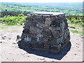
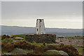
This stone is located SJ905636 on the back slope of Bosley Cloud, a hill in Cheshire. It is not known if this stone is prehistoric standing stone or a natural boulder but it has been utilised as a marker (a cross is carved into the top of the stone) for the Cheshire/Staffordshire county boundary which splits the Cloud. If it is natural it is fortuitously placed but it is a stone out of keeping with those in the immediate area.
A track runs right beside it.
You may be viewing yesterday's version of this page. To see the most up to date information please register for a free account.
 Standing Stone (PID:4470)")
 (PID:24341)")
 (PID:24340)")
Do not use the above information on other web sites or publications without permission of the contributor.
Nearby Images from Geograph Britain and Ireland:
©2010(licence)
©2015(licence)
©2016(licence)
©2014(licence)
©2015(licence)
The above images may not be of the site on this page, they are loaded from Geograph.
Please Submit an Image of this site or go out and take one for us!
Click here to see more info for this site
Nearby sites
Key: Red: member's photo, Blue: 3rd party photo, Yellow: other image, Green: no photo - please go there and take one, Grey: site destroyed
Download sites to:
KML (Google Earth)
GPX (GPS waypoints)
CSV (Garmin/Navman)
CSV (Excel)
To unlock full downloads you need to sign up as a Contributory Member. Otherwise downloads are limited to 50 sites.
Turn off the page maps and other distractions
Nearby sites listing. In the following links * = Image available
223m SSE 153° Bosley Cloud (2)* Standing Stone (Menhir) (SJ906634)
1.4km S 176° The Bridestones (Cheshire)* Chambered Tomb (SJ9058962190)
3.3km ESE 118° Satan's Stone* Natural Stone / Erratic / Other Natural Feature (SJ93406206)
3.3km SSW 195° Shepherd's Cross* Standing Stone (Menhir) (SJ89626042)
3.8km ESE 111° St Helen's Well (Rushton Spencer)* Holy Well or Sacred Spring (SJ94076222)
4.1km NE 56° Bosley Minn 1* Standing Stone (Menhir) (SJ93886585)
4.2km NE 55° Bosley Minn 2 & 3* Standing Stones (SJ940660)
4.4km NE 53° Bosley Minn 4 & 5* Standing Stones (SJ940662)
4.6km W 261° Congleton Museum* Museum (SJ859629)
5.0km E 98° Heaton Low* Round Barrow(s) (SJ955629)
6.0km NE 51° Clulow Cross* Round Barrow(s) (SJ952674)
6.1km N 9° Woodhouse End* Round Barrow(s) (SJ915696)
6.2km WSW 250° St Marys (Astbury)* Ancient Cross (SJ847615)
6.2km NNE 14° Gawsworth henge* Henge (SJ920696)
6.2km ENE 71° Bartomley Farm* Long Barrow (SJ964656)
6.3km NE 53° Longgutter* Round Barrow(s) (SJ955674)
6.3km WSW 251° Astbury Churchyard* Round Barrow(s) (SJ845616)
6.5km NE 51° Bullstones* Stone Circle (SJ9556867627)
6.5km NNE 14° Broad Oak Farm* Round Barrow(s) (SJ921699)
6.8km ESE 110° Gun Hill Standing Stone* Standing Stone (Menhir) (SJ969612)
6.9km NE 49° Cessbank Common* Round Barrow(s) (SJ958681)
7.0km ENE 65° Allgreave* Standing Stone (Menhir) (SJ969665)
7.2km SSW 199° Red Cross* Ancient Cross (SJ881568)
7.5km W 268° Loachbrook Farm* Long Barrow (SJ830634)
7.6km NE 42° The Plague Stone* Ancient Cross (SJ9561269221)
View more nearby sites and additional images


 We would like to know more about this location. Please feel free to add a brief description and any relevant information in your own language.
 Wir möchten mehr über diese Stätte erfahren. Bitte zögern Sie nicht, eine kurze Beschreibung und relevante Informationen in Deutsch hinzuzufügen.
 Nous aimerions en savoir encore un peu sur les lieux. S'il vous plaît n'hesitez pas à ajouter une courte description et tous les renseignements pertinents dans votre propre langue.
 Quisieramos informarnos un poco más de las lugares. No dude en añadir una breve descripción y otros datos relevantes en su propio idioma.