


<< Our Photo Pages >> Blacknoll Hill - Barrow Cemetery in England in Dorset
Submitted by TimPrevett on Sunday, 08 July 2007 Page Views: 6927
Neolithic and Bronze AgeSite Name: Blacknoll HillCountry: England County: Dorset Type: Barrow Cemetery
Nearest Town: Wool Nearest Village: East Knighton
Map Ref: SY80638630
Latitude: 50.676035N Longitude: 2.275496W
Condition:
| 5 | Perfect |
| 4 | Almost Perfect |
| 3 | Reasonable but with some damage |
| 2 | Ruined but still recognisable as an ancient site |
| 1 | Pretty much destroyed, possibly visible as crop marks |
| 0 | No data. |
| -1 | Completely destroyed |
| 5 | Superb |
| 4 | Good |
| 3 | Ordinary |
| 2 | Not Good |
| 1 | Awful |
| 0 | No data. |
| 5 | Can be driven to, probably with disabled access |
| 4 | Short walk on a footpath |
| 3 | Requiring a bit more of a walk |
| 2 | A long walk |
| 1 | In the middle of nowhere, a nightmare to find |
| 0 | No data. |
| 5 | co-ordinates taken by GPS or official recorded co-ordinates |
| 4 | co-ordinates scaled from a detailed map |
| 3 | co-ordinates scaled from a bad map |
| 2 | co-ordinates of the nearest village |
| 1 | co-ordinates of the nearest town |
| 0 | no data |
Internal Links:
External Links:
I have visited· I would like to visit
TimPrevett has visited here
")
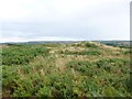
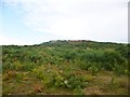
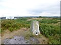
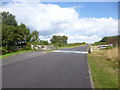
Six hard to spot bowl barrows atop Blacknoll Hill, courtesy of gorse, erosion, and infilling of the circular ditches. Vary in diameter from 30 to 60 feet, the highest no more than 4 feet. These are part of a larger group of barrows on Winfrith Heath.
You may be viewing yesterday's version of this page. To see the most up to date information please register for a free account.
")
")
Do not use the above information on other web sites or publications without permission of the contributor.
Nearby Images from Geograph Britain and Ireland:
©2014(licence)
©2014(licence)
©2014(licence)
©2014(licence)
©2014(licence)
The above images may not be of the site on this page, they are loaded from Geograph.
Please Submit an Image of this site or go out and take one for us!
Click here to see more info for this site
Nearby sites
Key: Red: member's photo, Blue: 3rd party photo, Yellow: other image, Green: no photo - please go there and take one, Grey: site destroyed
Download sites to:
KML (Google Earth)
GPX (GPS waypoints)
CSV (Garmin/Navman)
CSV (Excel)
To unlock full downloads you need to sign up as a Contributory Member. Otherwise downloads are limited to 50 sites.
Turn off the page maps and other distractions
Nearby sites listing. In the following links * = Image available
2.7km SW 218° Five Marys* Barrow Cemetery (SY790842)
3.5km SW 233° Lord's Barrow* Round Barrow(s) (SY778842)
4.2km E 98° Woodman's Cross* Barrow Cemetery (SY84838573)
5.1km SSW 194° Wardstone Barrow* Round Barrow(s) (SY79338133)
5.6km SSW 204° Chaldon Down* Barrow Cemetery (SY783812)
5.7km ESE 109° Coombe Beacon Barrow Cemetery (SY860844)
6.1km S 171° Hambury Tout Barrows* Barrow Cemetery (SY81588029)
6.5km SSE 157° Bindon Hill* Hillfort (SY831803)
6.7km WSW 246° Poxwell Cairn* Cairn (SY74518357)
6.9km SW 236° Southdown (Dorset)* Barrow Cemetery (SY749825)
6.9km SSE 150° Bindon Hill Barrows* Barrow Cemetery (SY84078026)
7.4km SE 127° Water Barrows Round Barrow(s) (SY865818)
7.5km SE 131° East Lulworth* Barrow Cemetery (SY863814)
7.5km SE 127° Ferny Barrows* Round Barrow(s) (SY866817)
7.7km ESE 106° Povington Heath Barrows Barrow Cemetery (SY880841)
7.9km SE 129° Boat Knoll* Round Barrow(s) (SY867813)
8.1km SE 135° Flower's Barrow* Hillfort (SY86388056)
8.3km SE 130° Lulworth stone circle Stone Circle (SY870810)
8.4km NNE 21° Devil's Stone (Dorset)* Standing Stone (Menhir) (SY837941)
8.6km W 274° Little Mayne* Stone Circle (SY720870)
8.9km NNE 27° Wool Road Sarsen Stone* Standing Stone (Menhir) (SY8467394244)
8.9km NW 304° Heedless William's Stone* Standing Stone (Menhir) (SY732913)
9.1km NW 309° Rainbarrows* Round Barrow(s) (SY735920)
9.1km WNW 282° Whitcombe* Standing Stone (Menhir) (SY717883)
9.5km E 83° Wareham Barrows Barrow Cemetery (SY90128737)
View more nearby sites and additional images


 We would like to know more about this location. Please feel free to add a brief description and any relevant information in your own language.
 Wir möchten mehr über diese Stätte erfahren. Bitte zögern Sie nicht, eine kurze Beschreibung und relevante Informationen in Deutsch hinzuzufügen.
 Nous aimerions en savoir encore un peu sur les lieux. S'il vous plaît n'hesitez pas à ajouter une courte description et tous les renseignements pertinents dans votre propre langue.
 Quisieramos informarnos un poco más de las lugares. No dude en añadir una breve descripción y otros datos relevantes en su propio idioma.