

<< Our Photo Pages >> Court Stane - Standing Stones in Scotland in Aberdeenshire
Submitted by cosmic on Monday, 09 July 2007 Page Views: 4891
Neolithic and Bronze AgeSite Name: Court StaneCountry: Scotland
NOTE: This site is 0.9 km away from the location you searched for.
County: Aberdeenshire Type: Standing Stones
Nearest Village: Glenbervie
Map Ref: NO7749579471
Latitude: 56.906025N Longitude: 2.371148W
Condition:
| 5 | Perfect |
| 4 | Almost Perfect |
| 3 | Reasonable but with some damage |
| 2 | Ruined but still recognisable as an ancient site |
| 1 | Pretty much destroyed, possibly visible as crop marks |
| 0 | No data. |
| -1 | Completely destroyed |
| 5 | Superb |
| 4 | Good |
| 3 | Ordinary |
| 2 | Not Good |
| 1 | Awful |
| 0 | No data. |
| 5 | Can be driven to, probably with disabled access |
| 4 | Short walk on a footpath |
| 3 | Requiring a bit more of a walk |
| 2 | A long walk |
| 1 | In the middle of nowhere, a nightmare to find |
| 0 | No data. |
| 5 | co-ordinates taken by GPS or official recorded co-ordinates |
| 4 | co-ordinates scaled from a detailed map |
| 3 | co-ordinates scaled from a bad map |
| 2 | co-ordinates of the nearest village |
| 1 | co-ordinates of the nearest town |
| 0 | no data |
Internal Links:
External Links:
")
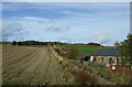
Over six feet high this standing stone is said to commemorate the death of Duncan II. It commands a good view to the south and east over the Mearns plain. Ariel photography suggests the possibility of a curvilinear enclosure with the stone at the inner South edge of it.
Although just off the A90 I have driven past it many times without seeing it due to it being the over side of the railway line. My access point from East Mondynes farm involved crossing four barbed wire fences!
You may be viewing yesterday's version of this page. To see the most up to date information please register for a free account.
")
")
")
Do not use the above information on other web sites or publications without permission of the contributor.
Nearby Images from Geograph Britain and Ireland:

©2005(licence)
©2021(licence)

©2019(licence)

©2019(licence)

©2024(licence)
The above images may not be of the site on this page, they are loaded from Geograph.
Please Submit an Image of this site or go out and take one for us!
Click here to see more info for this site
Nearby sites
Key: Red: member's photo, Blue: 3rd party photo, Yellow: other image, Green: no photo - please go there and take one, Grey: site destroyed
Download sites to:
KML (Google Earth)
GPX (GPS waypoints)
CSV (Garmin/Navman)
CSV (Excel)
To unlock full downloads you need to sign up as a Contributory Member. Otherwise downloads are limited to 50 sites.
Turn off the page maps and other distractions
Nearby sites listing. In the following links * = Image available
2.6km NW 315° Droop Hill Cairn (NO757813)
3.1km NE 43° Blackhill Wood* Chambered Cairn (NO796817)
3.3km SE 143° Hillhead (Aberdeen) Chambered Cairn (NO795768)
4.7km ESE 119° Montgoldrum Cairn (NO816772)
4.7km ESE 119° Montgoldrum* Stone Circle (NO816772)
4.8km ESE 110° Ley of Barras* Standing Stone (Menhir) (NO82037779)
4.9km ENE 78° Bruxie Hill Chambered Cairn (NO823805)
5.0km SSW 196° Cairn of Arthurhouse Cairn (NO761747)
5.0km WSW 257° Fordoun* Class II Pictish Symbol Stone (NO72617841)
5.0km ESE 115° Montgoldrum Cairn (NO820773)
5.1km WSW 258° St Palladius' Well* Holy Well or Sacred Spring (NO725784)
5.2km E 94° Cotbank Of Barras* Stone Circle (NO827791)
5.9km SE 134° Millplough Cairn* Cairn (NO81727540)
6.0km SE 132° Millplough Circle* Stone Circle (NO819754)
7.1km SSW 212° Erskine's Knap Round Barrow(s) (NO737734)
7.2km ENE 58° Dunnottar Stone Circle (NO836833)
8.0km E 100° Kinneff Cursus Cursus (NO85407800)
8.2km SSW 199° Cairn of Shiels Cairn (NO747717)
8.2km NNE 22° Fetteresso Standing Stone* Standing Stone (Menhir) (NO80598713)
8.4km NNE 19° Clochanshiels Ancient Village or Settlement (NO803874)
9.5km NE 49° Fetteresso Cursus Cursus (NO84698570)
9.8km SSE 154° Gourdon* Long Barrow (NO818706)
9.9km NE 49° Kirktown of Fetteresso* Ancient Village or Settlement (NO851859)
10.3km NE 36° Cheynehill Wood Enclosures Ancient Village or Settlement (NO836878)
10.4km NNE 27° Glenton Hill Enclosure Ancient Village or Settlement (NO823887)
View more nearby sites and additional images


 We would like to know more about this location. Please feel free to add a brief description and any relevant information in your own language.
 Wir möchten mehr über diese Stätte erfahren. Bitte zögern Sie nicht, eine kurze Beschreibung und relevante Informationen in Deutsch hinzuzufügen.
 Nous aimerions en savoir encore un peu sur les lieux. S'il vous plaît n'hesitez pas à ajouter une courte description et tous les renseignements pertinents dans votre propre langue.
 Quisieramos informarnos un poco más de las lugares. No dude en añadir una breve descripción y otros datos relevantes en su propio idioma.