


<< Text Pages >> White Scars - Cairn in England in Yorkshire (North)
Submitted by funsize on Monday, 04 June 2007 Page Views: 5770
Neolithic and Bronze AgeSite Name: White ScarsCountry: England
NOTE: This site is 1.4 km away from the location you searched for.
County: Yorkshire (North) Type: Cairn
Nearest Town: Ingleton
Map Ref: SD717738
Latitude: 54.159223N Longitude: 2.434875W
Condition:
| 5 | Perfect |
| 4 | Almost Perfect |
| 3 | Reasonable but with some damage |
| 2 | Ruined but still recognisable as an ancient site |
| 1 | Pretty much destroyed, possibly visible as crop marks |
| 0 | No data. |
| -1 | Completely destroyed |
| 5 | Superb |
| 4 | Good |
| 3 | Ordinary |
| 2 | Not Good |
| 1 | Awful |
| 0 | No data. |
| 5 | Can be driven to, probably with disabled access |
| 4 | Short walk on a footpath |
| 3 | Requiring a bit more of a walk |
| 2 | A long walk |
| 1 | In the middle of nowhere, a nightmare to find |
| 0 | No data. |
| 5 | co-ordinates taken by GPS or official recorded co-ordinates |
| 4 | co-ordinates scaled from a detailed map |
| 3 | co-ordinates scaled from a bad map |
| 2 | co-ordinates of the nearest village |
| 1 | co-ordinates of the nearest town |
| 0 | no data |
Internal Links:
External Links:
Cairn in Yorkshire (North)
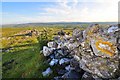
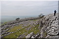
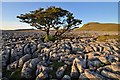
This is one of three cairns dotted about the limestone pavement at White Scars below Ingleborough mountain. Sadly no information seems to be available on this one. Could easily be very old... It has a prominent position on a ledge overlooking the valley - great place from which to view a sunset.
You may be viewing yesterday's version of this page. To see the most up to date information please register for a free account.
")
Do not use the above information on other web sites or publications without permission of the contributor.
Nearby Images from Geograph Britain and Ireland:
©2009(licence)
©2010(licence)
©2007(licence)
©2015(licence)
©2009(licence)
The above images may not be of the site on this page, they are loaded from Geograph.
Please Submit an Image of this site or go out and take one for us!
Click here to see more info for this site
Nearby sites
Key: Red: member's photo, Blue: 3rd party photo, Yellow: other image, Green: no photo - please go there and take one, Grey: site destroyed
Download sites to:
KML (Google Earth)
GPX (GPS waypoints)
CSV (Garmin/Navman)
CSV (Excel)
To unlock full downloads you need to sign up as a Contributory Member. Otherwise downloads are limited to 50 sites.
Turn off the page maps and other distractions
Nearby sites listing. In the following links * = Image available
2.1km NNW 328° Twisleton Scar Rock Outcrop (SD70597563)
2.6km ENE 74° Ingleborough Camp* Hillfort (SD7419374511)
4.6km NE 39° Keld Bank Settlement* Ancient Village or Settlement (SD74657734)
4.6km NE 41° Keld Bank (Ingleborough)* Rock Art (SD7475977253)
5.0km N 350° Apron Full of Stones* Ring Cairn (SD709787)
5.1km NE 38° Philpin Sleights* Rock Outcrop (SD7486677760)
5.4km NNW 346° Yordas cave* Cave or Rock Shelter (SD704790)
5.9km NE 44° Sleights Pasture Propped Stone* Rock Outcrop (SD7579578018)
6.0km NE 41° Sleights Pasture Round Barrow* Round Cairn (SD75677836)
6.2km SE 127° Norber Erratics Natural Stone / Erratic / Other Natural Feature (SD76597003)
6.8km E 82° Skirtful of Stones (Ingleborough) Cairn (SD785747)
6.8km NE 41° Batty Wife Hole Ring Cairn (SD76227895)
7.4km WNW 293° Leck Hall* Ancient Village or Settlement (SD64927677)
8.9km SSW 212° The Great Stone Of Fourstones* Natural Stone / Erratic / Other Natural Feature (SD6697266292)
9.5km SE 134° Feizor (Lawkland) Standing Stone (Menhir) (SD78586718)
9.6km NW 314° Brownthwaite Pike Round Cairn* Round Cairn (SD6477280479)
9.8km SSW 212° Ringstones (Lowgill) Stone Circle (SD664655)
9.9km NW 308° Casterton* Stone Circle (SD63937999)
10.3km SE 128° Feizor Thwaite (Lawkland) Ring Cairn (SD79796747)
10.3km W 270° St John the Baptist (Tunstall)* Early Christian Sculptured Stone (SD6141473925)
10.5km SE 127° Feizor Celtic Wall* Misc. Earthwork (SD8008067386)
11.3km SE 128° Feizor Thwaite Propped Stone* Rock Outcrop (SD8057466703)
11.4km SE 129° Sheep Scar Circle (Giggleswick) Ring Cairn (SD8051366473)
11.6km SE 129° Sheep Scar Cairn (Giggleswick) Cairn (SD8067866436)
11.7km WNW 287° Sellet Bank Enclosure* Ancient Village or Settlement (SD60517733)
View more nearby sites and additional images


 We would like to know more about this location. Please feel free to add a brief description and any relevant information in your own language.
 Wir möchten mehr über diese Stätte erfahren. Bitte zögern Sie nicht, eine kurze Beschreibung und relevante Informationen in Deutsch hinzuzufügen.
 Nous aimerions en savoir encore un peu sur les lieux. S'il vous plaît n'hesitez pas à ajouter une courte description et tous les renseignements pertinents dans votre propre langue.
 Quisieramos informarnos un poco más de las lugares. No dude en añadir una breve descripción y otros datos relevantes en su propio idioma.