


<< Text Pages >> Kingbarrow - Modern Stone Circle etc in England in Dorset
Submitted by Anonymous on Wednesday, 07 April 2010 Page Views: 6082
Neolithic and Bronze AgeSite Name: Kingbarrow Alternative Name: Sawmill stone circle, the Frolic, Easton druid templesCountry: England County: Dorset Type: Modern Stone Circle etc
Nearest Town: Fortuneswell
Map Ref: SY6907772745
Latitude: 50.553639N Longitude: 2.437861W
Condition:
| 5 | Perfect |
| 4 | Almost Perfect |
| 3 | Reasonable but with some damage |
| 2 | Ruined but still recognisable as an ancient site |
| 1 | Pretty much destroyed, possibly visible as crop marks |
| 0 | No data. |
| -1 | Completely destroyed |
| 5 | Superb |
| 4 | Good |
| 3 | Ordinary |
| 2 | Not Good |
| 1 | Awful |
| 0 | No data. |
| 5 | Can be driven to, probably with disabled access |
| 4 | Short walk on a footpath |
| 3 | Requiring a bit more of a walk |
| 2 | A long walk |
| 1 | In the middle of nowhere, a nightmare to find |
| 0 | No data. |
| 5 | co-ordinates taken by GPS or official recorded co-ordinates |
| 4 | co-ordinates scaled from a detailed map |
| 3 | co-ordinates scaled from a bad map |
| 2 | co-ordinates of the nearest village |
| 1 | co-ordinates of the nearest town |
| 0 | no data |
Internal Links:
External Links:
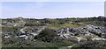
This (probably modern) stone circle is often missed by many who come to Portland and is widely unknown to even most residents. It is a small stone circle only some 16ft across. it is made of small stones only 4ft or smaller and is located on the grounds of an old limekiln.
I'm not sure if entry to this site is permitted as it is fenced off with barbed wire but there is an entry gate. I go in there and have never been informed that I am not supposed to be in their but it is best to ask at the limekiln house just in front of the building first. The stone circle itself is located in an old Roman quarry which used to be a great burial site. Many Roman sarcophagus have been found here and the place has a lovely ambiance. There is also an old mine like tunnel. I'm not sure of its age but it is well worth a visit but not for the faint of heart because the 5 ton stones lining the roof are having to be supported by rusty iron support struts.
Despite its proximity to one of the two main roads on the island it has actually got quite a nice feel to the place. I hope you come to document this place properly as their are not many registered sites on Portland of megalithic origin all though I am sure if people looked their are probably more than you think. I have not looked properly but there is a record that says that their was another stone circle on the other side of the road but I have not checked or bothered looking for it but it may exist and will be well worth the visit.
You may be viewing yesterday's version of this page. To see the most up to date information please register for a free account.
Do not use the above information on other web sites or publications without permission of the contributor.
Nearby Images from Geograph Britain and Ireland:
©2018(licence)
©2018(licence)
©2020(licence)
©2018(licence)
©2021(licence)
The above images may not be of the site on this page, they are loaded from Geograph.
Please Submit an Image of this site or go out and take one for us!
Click here to see more info for this site
Nearby sites
Key: Red: member's photo, Blue: 3rd party photo, Yellow: other image, Green: no photo - please go there and take one, Grey: site destroyed
Download sites to:
KML (Google Earth)
GPX (GPS waypoints)
CSV (Garmin/Navman)
CSV (Excel)
To unlock full downloads you need to sign up as a Contributory Member. Otherwise downloads are limited to 50 sites.
Turn off the page maps and other distractions
Nearby sites listing. In the following links * = Image available
355m WNW 289° Tout Quarry Sculpture Park Stone Circle* Modern Stone Circle etc (SY68747286)
513m W 279° Tout Quarry Sculpture Park Alignment* Modern Stone Circle etc (SY68577283)
735m WSW 249° Tout Quarry Sculpture Park - The Circle of Stones* Modern Stone Circle etc (SY68397248)
816m WNW 288° Jacob's Well (Portland)* Holy Well or Sacred Spring (SY683730)
1.3km ESE 110° Grove Road* Stone Circle (SY703723)
3.5km S 189° Culverwell Mesolithic Site* Ancient Village or Settlement (SY685693)
4.7km SSW 199° Pulpit Rock (Portland)* Rock Outcrop (SY675683)
5.6km NNW 343° Dripping Well (Weymouth) Holy Well or Sacred Spring (SY6750478079)
11.1km N 2° Chalbury* Hillfort (SY695838)
11.4km NNE 30° Southdown (Dorset)* Barrow Cemetery (SY749825)
12.0km N 359° Bincombe Barrows* Barrow Cemetery (SY689847)
12.1km NNE 26° Poxwell Cairn* Cairn (SY74518357)
12.2km N 8° Northdown (Dorset)* Barrow Cemetery (SY708848)
12.5km NE 47° Chaldon Down* Barrow Cemetery (SY783812)
12.6km N 5° Broadmayne Bank Barrow* Long Barrow (SY702853)
12.8km NNW 346° Upwey Wishing Well* Holy Well or Sacred Spring (SY661852)
13.0km N 354° Bincombe Down* Barrow Cemetery (SY679857)
13.1km N 3° Whitcombe 1* Long Barrow (SY699858)
13.2km N 352° Ridgeway Hill* Barrow Cemetery (SY672858)
13.3km N 355° Winterborne Came 18b (Bincombe) Cairn (SY680860)
13.4km NE 50° Wardstone Barrow* Round Barrow(s) (SY79338133)
13.6km N 358° Came Down* Barrow Cemetery (SY687863)
13.7km NNW 338° Friar Waddon Hill Barrow Cemetery (SY641855)
14.1km NNW 348° Upwey Ridgeway* Barrow Cemetery (SY66298659)
14.4km NE 37° Lord's Barrow* Round Barrow(s) (SY778842)
View more nearby sites and additional images


 We would like to know more about this location. Please feel free to add a brief description and any relevant information in your own language.
 Wir möchten mehr über diese Stätte erfahren. Bitte zögern Sie nicht, eine kurze Beschreibung und relevante Informationen in Deutsch hinzuzufügen.
 Nous aimerions en savoir encore un peu sur les lieux. S'il vous plaît n'hesitez pas à ajouter une courte description et tous les renseignements pertinents dans votre propre langue.
 Quisieramos informarnos un poco más de las lugares. No dude en añadir una breve descripción y otros datos relevantes en su propio idioma.