

<< Our Photo Pages >> Whitehill Stone Circle - Stone Circle in Scotland in Aberdeenshire
Submitted by cosmic on Tuesday, 06 April 2004 Page Views: 17021
Neolithic and Bronze AgeSite Name: Whitehill Stone CircleCountry: Scotland
NOTE: This site is 2.1 km away from the location you searched for.
County: Aberdeenshire Type: Stone Circle
Nearest Village: Tillyfourie
Map Ref: NJ643135 Landranger Map Number: 37
Latitude: 57.210864N Longitude: 2.592647W
Condition:
| 5 | Perfect |
| 4 | Almost Perfect |
| 3 | Reasonable but with some damage |
| 2 | Ruined but still recognisable as an ancient site |
| 1 | Pretty much destroyed, possibly visible as crop marks |
| 0 | No data. |
| -1 | Completely destroyed |
| 5 | Superb |
| 4 | Good |
| 3 | Ordinary |
| 2 | Not Good |
| 1 | Awful |
| 0 | No data. |
| 5 | Can be driven to, probably with disabled access |
| 4 | Short walk on a footpath |
| 3 | Requiring a bit more of a walk |
| 2 | A long walk |
| 1 | In the middle of nowhere, a nightmare to find |
| 0 | No data. |
| 5 | co-ordinates taken by GPS or official recorded co-ordinates |
| 4 | co-ordinates scaled from a detailed map |
| 3 | co-ordinates scaled from a bad map |
| 2 | co-ordinates of the nearest village |
| 1 | co-ordinates of the nearest town |
| 0 | no data |
Internal Links:
External Links:
I have visited· I would like to visit
SolarMegalith would like to visit
pawel visited on 13th Jan 2020 - their rating: Cond: 3 Amb: 4 Access: 3
pmabz visited on 23rd Oct 2010 - their rating: Access: 2 recumbent stone on SW-ish
1 mile walk on forest track
megalithicmatt visited on 1st Jan 2003 - their rating: Cond: 3 Amb: 4 Access: 3 Nice walk in, atmospheric site.
rldixon HaggisAction have visited here
Average ratings for this site from all visit loggers: Condition: 3 Ambience: 4 Access: 2.67
")
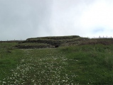
Whitehill in Aberdeenshire at NJ 643135 is graded by Burl as ruined but recognisable but still appears in his Guide to Stone Circles.
Recently the surrounding wood has been harvested so it can be seen in context.
Only the West flanker (about 8 feet tall) and a stone in the NW corner are still standing but the general shape is obvious from the fallen stones and the cairn inside.
You may be viewing yesterday's version of this page. To see the most up to date information please register for a free account.
")
")
")
")
")
")
")
")
")
")
")
")
")
")
Do not use the above information on other web sites or publications without permission of the contributor.
Click here to see more info for this site
Nearby sites
Key: Red: member's photo, Blue: 3rd party photo, Yellow: other image, Green: no photo - please go there and take one, Grey: site destroyed
Download sites to:
KML (Google Earth)
GPX (GPS waypoints)
CSV (Garmin/Navman)
CSV (Excel)
To unlock full downloads you need to sign up as a Contributory Member. Otherwise downloads are limited to 50 sites.
![]()
![]()
Turn off the page maps and other distractions
Nearby sites listing. In the following links * = Image available
1.4km N 349° Luath's Stone* Standing Stone (Menhir) (NJ64041489)
2.3km NE 40° Monymusk 2 Early Christian Sculptured Stone (NJ65801524)
3.7km ENE 78° Tombeg* Standing Stone (Menhir) (NJ67931426)
4.5km ENE 67° Monymusk* Class II Pictish Symbol Stone (NJ68501524)
4.6km ENE 62° Deer Park* Stone Circle (NJ68341564)
4.7km SSW 202° Auld Kirk O Tough* Stone Circle (NJ625092)
5.8km S 172° Tomnagorn* Stone Circle (NJ651077)
5.9km W 272° North Strone* Stone Circle (NJ584138)
6.7km E 90° Woodend of Cluny* Standing Stone (Menhir) (NJ7105613433)
6.8km NNW 337° Cothiemuir Wood* Stone Circle (NJ61711980)
6.9km WSW 245° Howemill* Stone Circle (NJ580107)
7.0km ENE 72° Nether Coullie* Stone Circle (NJ70981565)
7.2km E 97° Castle Fraser circle* Stone Circle (NJ71501253)
7.3km NW 311° Crookmore Multiple Stone Rows / Avenue (NJ588184)
7.3km NW 311° Crookmore Stone Circle (NJ588184)
7.5km E 97° Castle Fraser Row* Stone Row / Alignment (NJ71741252)
7.5km NW 321° Old Keig* Stone Circle (NJ59651939)
7.7km WNW 302° Druidsfield* Multiple Stone Rows / Avenue (NJ578177)
7.7km WNW 302° Druidsfield* Stone Circle (NJ578177)
7.8km E 95° John Bell's Stone* Standing Stone (Menhir) (NJ72111271)
7.9km NW 326° Barmkyn of North Keig* Hillfort (NJ59912004)
8.2km E 79° Lang Stane o' Craigearn* Standing Stone (Menhir) (NJ72381493)
8.3km NE 49° Chapel O' Sink* Stone Circle (NJ706189)
8.5km WSW 253° Drumfours* Stone Circle (NJ561110)
8.9km SE 141° Midmar Kirk N* Standing Stone (Menhir) (NJ69870659)
View more nearby sites and additional images


 We would like to know more about this location. Please feel free to add a brief description and any relevant information in your own language.
 Wir möchten mehr über diese Stätte erfahren. Bitte zögern Sie nicht, eine kurze Beschreibung und relevante Informationen in Deutsch hinzuzufügen.
 Nous aimerions en savoir encore un peu sur les lieux. S'il vous plaît n'hesitez pas à ajouter une courte description et tous les renseignements pertinents dans votre propre langue.
 Quisieramos informarnos un poco más de las lugares. No dude en añadir una breve descripción y otros datos relevantes en su propio idioma.