


<< Our Photo Pages >> Bold Venture - Ancient Mine, Quarry or other Industry in England in Northumberland
Submitted by David on Friday, 21 January 2022 Page Views: 709
Multi-periodSite Name: Bold Venture Alternative Name: Copper mine at the KnarCountry: England County: Northumberland Type: Ancient Mine, Quarry or other Industry
Nearest Town: Alston Nearest Village: Slaggyford
Map Ref: NY657513
Latitude: 54.855310N Longitude: 2.535794W
Condition:
| 5 | Perfect |
| 4 | Almost Perfect |
| 3 | Reasonable but with some damage |
| 2 | Ruined but still recognisable as an ancient site |
| 1 | Pretty much destroyed, possibly visible as crop marks |
| 0 | No data. |
| -1 | Completely destroyed |
| 5 | Superb |
| 4 | Good |
| 3 | Ordinary |
| 2 | Not Good |
| 1 | Awful |
| 0 | No data. |
| 5 | Can be driven to, probably with disabled access |
| 4 | Short walk on a footpath |
| 3 | Requiring a bit more of a walk |
| 2 | A long walk |
| 1 | In the middle of nowhere, a nightmare to find |
| 0 | No data. |
| 5 | co-ordinates taken by GPS or official recorded co-ordinates |
| 4 | co-ordinates scaled from a detailed map |
| 3 | co-ordinates scaled from a bad map |
| 2 | co-ordinates of the nearest village |
| 1 | co-ordinates of the nearest town |
| 0 | no data |
Internal Links:
External Links:
")
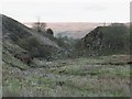
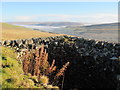
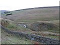
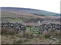
There is a bank of copper slag upstream that dates to the late medieval period and gives the nearby settlement of Slaggyford its name. (The very old track to Croglin comes by this way). Mining ceased in the 1720s. The mine has never been investigated in any way and forks after about 300m, after a scary roof collapse. Spoil from the mine will've been simply dumped in the river and become sediment downstream. There is a path to it beside the river, from beyond the sheep dip yards at the farm, but it is difficult. – Right To Roam access.
You may be viewing yesterday's version of this page. To see the most up to date information please register for a free account.
")
")
")
Do not use the above information on other web sites or publications without permission of the contributor.
Nearby Images from Geograph Britain and Ireland:
©2007(licence)
©2007(licence)
©2012(licence)
©2007(licence)
©2007(licence)
The above images may not be of the site on this page, they are loaded from Geograph.
Please Submit an Image of this site or go out and take one for us!
Click here to see more info for this site
Nearby sites
Key: Red: member's photo, Blue: 3rd party photo, Yellow: other image, Green: no photo - please go there and take one, Grey: site destroyed
Download sites to:
KML (Google Earth)
GPX (GPS waypoints)
CSV (Garmin/Navman)
CSV (Excel)
To unlock full downloads you need to sign up as a Contributory Member. Otherwise downloads are limited to 50 sites.
Turn off the page maps and other distractions
Nearby sites listing. In the following links * = Image available
453m E 92° Knarsdale N01 Rock Art (NY6615451284)
499m NW 323° Hut Burn Roundhouse* Ancient Village or Settlement (NY654517)
519m ENE 72° Knaresdale 1 Rock Art (NY6619751454)
598m E 90° Slaggyford Stones* Standing Stones (NY663513)
608m S 170° Butter Well Cairns* Cairn (NY658507)
804m ENE 60° Knar Standing Stone* Standing Stone (Menhir) (NY664517)
905m N 353° Hanging Shaw Long Cairn* Cairn (NY656522)
948m SSE 161° Tot's Cupmarked Stone* Standing Stone (Menhir) (NY660504)
1.0km ESE 119° Longpot Head Stone Circle* Stone Circle (NY666508)
1.1km E 90° Coal Tips Barrow Artificial Mound (NY668513)
1.2km SE 138° David's Cobs* Cairn (NY665504)
1.4km E 90° Robbed Cairn* Cairn (NY671513)
1.9km ENE 68° Amos Hill* Artificial Mound (NY675520)
2.1km SSW 209° Green Hill Standing Stone* Standing Stone (Menhir) (NY647495)
2.1km S 177° Tot's Four-Poster* Stone Circle (NY658492)
2.2km SSW 206° Green Hill Cairns* Cairn (NY647493)
2.6km E 89° Low Thornhope Farm Rock Art (NY6825951318)
2.6km SSW 200° Raillton Sike Cist* Cist (NY648489)
2.6km E 90° Slaggyford Stone Rows* Stone Row / Alignment (NY683513)
2.6km E 92° Lintley Observatory* Misc. Earthwork (NY683512)
3.2km WNW 295° Colouring Crags Long Cairn* Long Barrow (NY628527)
3.6km E 87° Saffron Well (Barhaugh)* Holy Well or Sacred Spring (NY69285148)
3.6km SSW 210° Broad Mea Long Cairn* Cairn (NY639482)
3.7km SSE 166° Grey Nag Cairn* Cairn (NY666477)
3.8km ESE 103° Railway Barrow* Artificial Mound (NY694504)
View more nearby sites and additional images


 We would like to know more about this location. Please feel free to add a brief description and any relevant information in your own language.
 Wir möchten mehr über diese Stätte erfahren. Bitte zögern Sie nicht, eine kurze Beschreibung und relevante Informationen in Deutsch hinzuzufügen.
 Nous aimerions en savoir encore un peu sur les lieux. S'il vous plaît n'hesitez pas à ajouter une courte description et tous les renseignements pertinents dans votre propre langue.
 Quisieramos informarnos un poco más de las lugares. No dude en añadir una breve descripción y otros datos relevantes en su propio idioma.