

, Aubrey Burl")
<< Our Photo Pages >> Kings Well spring - Holy Well or Sacred Spring in England in Cumbria
Submitted by nicoladidsbury on Thursday, 03 June 2004 Page Views: 7520
Springs and Holy WellsSite Name: Kings Well springCountry: England
NOTE: This site is 0.6 km away from the location you searched for.
County: Cumbria Type: Holy Well or Sacred Spring
Nearest Town: Shap Nearest Village: Orton
Map Ref: NY612108 Landranger Map Number: 91
Latitude: 54.491042N Longitude: 2.600486W
Condition:
| 5 | Perfect |
| 4 | Almost Perfect |
| 3 | Reasonable but with some damage |
| 2 | Ruined but still recognisable as an ancient site |
| 1 | Pretty much destroyed, possibly visible as crop marks |
| 0 | No data. |
| -1 | Completely destroyed |
| 5 | Superb |
| 4 | Good |
| 3 | Ordinary |
| 2 | Not Good |
| 1 | Awful |
| 0 | No data. |
| 5 | Can be driven to, probably with disabled access |
| 4 | Short walk on a footpath |
| 3 | Requiring a bit more of a walk |
| 2 | A long walk |
| 1 | In the middle of nowhere, a nightmare to find |
| 0 | No data. |
| 5 | co-ordinates taken by GPS or official recorded co-ordinates |
| 4 | co-ordinates scaled from a detailed map |
| 3 | co-ordinates scaled from a bad map |
| 2 | co-ordinates of the nearest village |
| 1 | co-ordinates of the nearest town |
| 0 | no data |
Internal Links:
External Links:
I have visited· I would like to visit
nicoladidsbury has visited here
")
Kings Well ancient spring lies just inside a stone wall on the edge of the Coast to Coast walk. This is a very unusual spring. A stone "hut", made of very old, very large sandstone slabs, covers a trough, though it is very unlikely to have been built for animals to use. One stone has a circle cut into it. The stream runs a little further to the source, and stone walls have been built on either side. We couldn't fathom out why. There are remains of earth banks on the hillside just to the west of the spring. A possible hillfort or settlement. White Hag Hill Stone Circle is further up the fell to the west. It made me wonder if the well and the earth enbankments are co-related, and the term Kings Well, could mean this was the hillfort settlement of a celtic leader.
You may be viewing yesterday's version of this page. To see the most up to date information please register for a free account.
")
Do not use the above information on other web sites or publications without permission of the contributor.
Nearby Images from Geograph Britain and Ireland:
©2016(licence)
©2020(licence)
©2018(licence)
©2013(licence)
©2015(licence)
The above images may not be of the site on this page, they are loaded from Geograph.
Please Submit an Image of this site or go out and take one for us!
Click here to see more info for this site
Nearby sites
Key: Red: member's photo, Blue: 3rd party photo, Yellow: other image, Green: no photo - please go there and take one, Grey: site destroyed
Download sites to:
KML (Google Earth)
GPX (GPS waypoints)
CSV (Garmin/Navman)
CSV (Excel)
To unlock full downloads you need to sign up as a Contributory Member. Otherwise downloads are limited to 50 sites.
Turn off the page maps and other distractions
Nearby sites listing. In the following links * = Image available
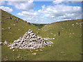
141m NW 315° Hazel Moor Enclosure* Ancient Village or Settlement (NY611109)
802m NNW 346° White Hag Round cairn* Round Cairn (NY61011158)
932m NNW 329° White Hag* Stone Circle (NY60721160)
1.2km NW 319° Wicker Street* Cairn (NY60411173)
1.2km NNE 15° Cow Green Long Barrow* Long Barrow (NY61541199)
1.3km ESE 103° Howe Robin Ancient Village or Settlement (NY625105)
1.7km ESE 102° Penhurrock* Multiple Stone Rows / Avenue (NY62881043)
1.8km NNE 33° Burwens Ancient Village or Settlement (NY622123)
1.9km W 271° Long Scar Pike* Cairn (NY5933810862)
2.0km N 357° Ewe Locks* Ancient Village or Settlement (NY6112512794)
2.3km NNW 336° Seal Howe Cairn 3* Round Cairn (NY6025312925)
2.5km NW 322° Seal Howe Cairn 2* Round Cairn (NY5969912781)
2.5km NW 319° Seal Howe* Cairn (NY59541272)
2.5km NW 321° Seal Howe Iron Age/Romano British field system* Misc. Earthwork (NY5961612783)
2.6km WSW 250° The Galloway Stone* Natural Stone / Erratic / Other Natural Feature (NY58780994)
2.7km N 356° Ewe Close* Ancient Village or Settlement (NY61021348)
2.8km NNE 31° Howarcles Ancient Village or Settlement (NY627132)
2.9km NW 316° Oddendale* Stone Circle (NY59201291)
3.1km NW 320° Oddendale stone alignment* Stone Row / Alignment (NY5919113205)
3.2km NW 323° Kalmott cairn circle* Ring Cairn (NY59301333)
3.3km NNE 15° Crosby Ravensworth Stone Row* Multiple Stone Rows / Avenue (NY6212514022)
3.4km NE 48° Raise Howe Cairn* Cairn (NY63711303)
3.5km WNW 303° St Anne's Well (Shap)* Holy Well or Sacred Spring (NY5829412700)
3.5km E 83° Gaythorn Plain* Ring Cairn (NY647112)
3.6km NW 322° Hardendale Timber Circle (NY590137)
View more nearby sites and additional images


 We would like to know more about this location. Please feel free to add a brief description and any relevant information in your own language.
 Wir möchten mehr über diese Stätte erfahren. Bitte zögern Sie nicht, eine kurze Beschreibung und relevante Informationen in Deutsch hinzuzufügen.
 Nous aimerions en savoir encore un peu sur les lieux. S'il vous plaît n'hesitez pas à ajouter une courte description et tous les renseignements pertinents dans votre propre langue.
 Quisieramos informarnos un poco más de las lugares. No dude en añadir una breve descripción y otros datos relevantes en su propio idioma.