


<< Our Photo Pages >> Dardannus Stone - Standing Stone (Menhir) in Scotland in Aberdeenshire
Submitted by cosmic on Thursday, 25 March 2004 Page Views: 5847
Neolithic and Bronze AgeSite Name: Dardannus StoneCountry: Scotland
NOTE: This site is 0.2 km away from the location you searched for.
County: Aberdeenshire Type: Standing Stone (Menhir)
Nearest Town: Aberdeen Nearest Village: Finzean
Map Ref: NO595940 Landranger Map Number: 37
Latitude: 57.035307N Longitude: 2.668938W
Condition:
| 5 | Perfect |
| 4 | Almost Perfect |
| 3 | Reasonable but with some damage |
| 2 | Ruined but still recognisable as an ancient site |
| 1 | Pretty much destroyed, possibly visible as crop marks |
| 0 | No data. |
| -1 | Completely destroyed |
| 5 | Superb |
| 4 | Good |
| 3 | Ordinary |
| 2 | Not Good |
| 1 | Awful |
| 0 | No data. |
| 5 | Can be driven to, probably with disabled access |
| 4 | Short walk on a footpath |
| 3 | Requiring a bit more of a walk |
| 2 | A long walk |
| 1 | In the middle of nowhere, a nightmare to find |
| 0 | No data. |
| 5 | co-ordinates taken by GPS or official recorded co-ordinates |
| 4 | co-ordinates scaled from a detailed map |
| 3 | co-ordinates scaled from a bad map |
| 2 | co-ordinates of the nearest village |
| 1 | co-ordinates of the nearest town |
| 0 | no data |
Internal Links:
External Links:
")
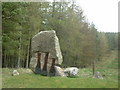
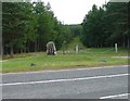
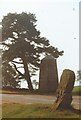
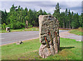
The Dardannus Stone is at NO 595940 on the crest of Corsedarder Hill on the B976. The original is dwarfed by a War Memorial and the erection of the Birse Millenium Stone in 2000.
The Dardannus Stone, named after the 20th Scottish King, is about 4 feet high and sports iron staples to hold it together after it was broken in road widening in the late 19th century.
You may be viewing yesterday's version of this page. To see the most up to date information please register for a free account.
")
Do not use the above information on other web sites or publications without permission of the contributor.
coldrum has found this location on Google Street View:
Nearby Images from Geograph Britain and Ireland:

©2007(licence)
©2006(licence)
©2005(licence)
©2014(licence)
©2008(licence)
The above images may not be of the site on this page, they are loaded from Geograph.
Please Submit an Image of this site or go out and take one for us!
Click here to see more info for this site
Nearby sites
Key: Red: member's photo, Blue: 3rd party photo, Yellow: other image, Green: no photo - please go there and take one, Grey: site destroyed
Download sites to:
KML (Google Earth)
GPX (GPS waypoints)
CSV (Garmin/Navman)
CSV (Excel)
To unlock full downloads you need to sign up as a Contributory Member. Otherwise downloads are limited to 50 sites.
Turn off the page maps and other distractions
Nearby sites listing. In the following links * = Image available
206m ENE 75° Corsedardar* Standing Stone (Menhir) (NO59709405)
499m SW 233° Finzean House* Chambered Cairn (NO591937)
988m NW 314° Berrysloch* Standing Stone (Menhir) (NO588947)
2.5km NE 36° Inchbaire Stone Circle (NO610960)
5.2km NW 309° Birse* Class I Pictish Symbol Stone (NO555973)
5.7km N 356° St Erchan's Well* Holy Well or Sacred Spring (NO592997)
6.5km E 98° Bucharn* Round Cairn (NO65949300)
7.1km NW 325° Dess Stone Circle* Modern Stone Circle etc (NO55449985)
7.3km WNW 302° Waterside Hut Circles Ancient Village or Settlement (NO533979)
7.5km WSW 242° Ballochan Hut Circles Ancient Village or Settlement (NO528905)
7.8km NE 43° Glassel* Stone Circle (NO64909969)
8.1km NW 318° Formaston* Class II Pictish Symbol Stone (NJ541001)
8.5km NW 311° Lady Well (Aboyne)* Holy Well or Sacred Spring (NO531996)
8.7km NW 305° Image Wood* Stone Circle (NO524990)
9.0km ENE 76° Inchmarlo* Standing Stone (Menhir) (NO68249613)
9.0km N 355° Cairn Mude* Cairn (NJ58870301)
9.5km NNE 28° Craigmyle* Class I Pictish Symbol Stone (NJ64020235)
9.6km N 4° Balnacraig Stone Circle* Stone Circle (NJ60330353)
9.6km NNE 16° Learney Standing Stone* Standing Stone (Menhir) (NJ62290318)
10.8km SSE 161° Glen Dye Fogou* Souterrain (Fogou, Earth House) (NO629837)
11.4km N 351° Macbeth's Cairn* Cairn (NJ578053)
11.9km WNW 292° Ferrar Ancient Village or Settlement (NO485986)
12.3km WNW 302° Blue Cairn (Cairn)* Cairn (NJ49070059)
12.4km E 101° Esslie The Greater* Stone Circle (NO71729159)
12.5km ESE 107° Midtown Ancient Village or Settlement (NO715903)
View more nearby sites and additional images


 We would like to know more about this location. Please feel free to add a brief description and any relevant information in your own language.
 Wir möchten mehr über diese Stätte erfahren. Bitte zögern Sie nicht, eine kurze Beschreibung und relevante Informationen in Deutsch hinzuzufügen.
 Nous aimerions en savoir encore un peu sur les lieux. S'il vous plaît n'hesitez pas à ajouter une courte description et tous les renseignements pertinents dans votre propre langue.
 Quisieramos informarnos un poco más de las lugares. No dude en añadir una breve descripción y otros datos relevantes en su propio idioma.