


<< Our Photo Pages >> North Strone - Stone Circle in Scotland in Aberdeenshire
Submitted by cosmic on Monday, 26 July 2004 Page Views: 8482
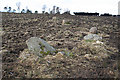
Neolithic and Bronze AgeSite Name: North StroneCountry: Scotland County: Aberdeenshire Type: Stone Circle
Map Ref: NJ584138 Landranger Map Number: 37
Latitude: 57.213060N Longitude: 2.690364W
Condition:
| 5 | Perfect |
| 4 | Almost Perfect |
| 3 | Reasonable but with some damage |
| 2 | Ruined but still recognisable as an ancient site |
| 1 | Pretty much destroyed, possibly visible as crop marks |
| 0 | No data. |
| -1 | Completely destroyed |
| 5 | Superb |
| 4 | Good |
| 3 | Ordinary |
| 2 | Not Good |
| 1 | Awful |
| 0 | No data. |
| 5 | Can be driven to, probably with disabled access |
| 4 | Short walk on a footpath |
| 3 | Requiring a bit more of a walk |
| 2 | A long walk |
| 1 | In the middle of nowhere, a nightmare to find |
| 0 | No data. |
| 5 | co-ordinates taken by GPS or official recorded co-ordinates |
| 4 | co-ordinates scaled from a detailed map |
| 3 | co-ordinates scaled from a bad map |
| 2 | co-ordinates of the nearest village |
| 1 | co-ordinates of the nearest town |
| 0 | no data |
Internal Links:
External Links:
I have visited· I would like to visit
SolarMegalith would like to visit
megalithicmatt visited on 5th Nov 2011 - their rating: Cond: 4 Amb: 5 Access: 3 A complete circle, how rare! The stones are extremely small and the hilltop is extremely windy.
")
You may be viewing yesterday's version of this page. To see the most up to date information please register for a free account.
")
")
")
")
Do not use the above information on other web sites or publications without permission of the contributor.
Nearby Images from Geograph Britain and Ireland:
©2016(licence)
©2016(licence)
©2016(licence)
©2016(licence)
©2016(licence)
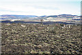
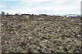
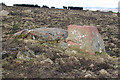
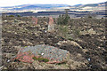
The above images may not be of the site on this page, they are loaded from Geograph.
Please Submit an Image of this site or go out and take one for us!
Click here to see more info for this site
Nearby sites
Key: Red: member's photo, Blue: 3rd party photo, Yellow: other image, Green: no photo - please go there and take one, Grey: site destroyed
Download sites to:
KML (Google Earth)
GPX (GPS waypoints)
CSV (Garmin/Navman)
CSV (Excel)
To unlock full downloads you need to sign up as a Contributory Member. Otherwise downloads are limited to 50 sites.
![]()
Turn off the page maps and other distractions
Nearby sites listing. In the following links * = Image available
3.1km S 187° Howemill* Stone Circle (NJ580107)
3.6km SW 219° Drumfours* Stone Circle (NJ561110)
3.9km N 351° Druidsfield* Multiple Stone Rows / Avenue (NJ578177)
3.9km N 351° Druidsfield* Stone Circle (NJ578177)
4.6km N 4° Crookmore Multiple Stone Rows / Avenue (NJ588184)
4.6km N 4° Crookmore Stone Circle (NJ588184)
5.6km NW 307° Nether Balfour Stone Circle (NJ539172)
5.6km NW 307° Nether Balfour Multiple Stone Rows / Avenue (NJ539172)
5.7km NNE 12° Old Keig* Stone Circle (NJ59651939)
5.7km ENE 78° Luath's Stone* Standing Stone (Menhir) (NJ64041489)
5.9km E 92° Whitehill Stone Circle* Stone Circle (NJ643135)
6.1km SE 138° Auld Kirk O Tough* Stone Circle (NJ625092)
6.4km NNE 13° Barmkyn of North Keig* Hillfort (NJ59912004)
6.8km NNE 28° Cothiemuir Wood* Stone Circle (NJ61711980)
7.4km NNW 334° Corrie Cairn* Stone Circle (NJ55222052)
7.5km ENE 78° Monymusk 2 Early Christian Sculptured Stone (NJ65801524)
8.4km SW 230° Holmhead stone circle* Modern Stone Circle etc (NJ51850849)
8.5km S 183° Macbeth's Cairn* Cairn (NJ578053)
9.0km NNE 20° Druidstone (Brackla)* Stone Circle (NJ6152922206)
9.0km SE 132° Tomnagorn* Stone Circle (NJ651077)
9.4km W 263° Elphillock (Kildrummy) Cairn (NJ49071274)
9.5km E 87° Tombeg* Standing Stone (Menhir) (NJ67931426)
10.1km E 79° Deer Park* Stone Circle (NJ68341564)
10.1km SW 228° Hillhead Stone Circle Stone Circle (NJ50720714)
10.2km E 81° Monymusk* Class II Pictish Symbol Stone (NJ68501524)
View more nearby sites and additional images


 We would like to know more about this location. Please feel free to add a brief description and any relevant information in your own language.
 Wir möchten mehr über diese Stätte erfahren. Bitte zögern Sie nicht, eine kurze Beschreibung und relevante Informationen in Deutsch hinzuzufügen.
 Nous aimerions en savoir encore un peu sur les lieux. S'il vous plaît n'hesitez pas à ajouter une courte description et tous les renseignements pertinents dans votre propre langue.
 Quisieramos informarnos un poco más de las lugares. No dude en añadir una breve descripción y otros datos relevantes en su propio idioma.