Featured: How and why the ancients enchanted Great Britain and Brittany

How and why the ancients enchanted Great Britain and Brittany

Megaliths by David Corio

Megaliths by David Corio

Who's Online

There are currently, 227 guests and 4 members online.

You are a guest. To join in, please register for free by clicking here

Sponsors

<< Our Photo Pages >> Long Bredy Bank Barrow - Long Barrow in England in Dorset

Submitted by JimChampion on Friday, 13 September 2013  Page Views: 13794

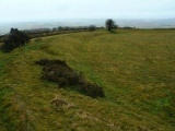
Neolithic and Bronze AgeSite Name: Long Bredy Bank Barrow Alternative Name: Long Bredy 1
Country: England County: Dorset Type: Long Barrow
Nearest Town: Dorchester  Nearest Village: Long Bredy
Map Ref: SY57179115  Landranger Map Number: 194
Latitude: 50.718389N  Longitude: 2.608062W
Condition:
5Perfect
4Almost Perfect
3Reasonable but with some damage
2Ruined but still recognisable as an ancient site
1Pretty much destroyed, possibly visible as crop marks
0No data.
-1Completely destroyed
3 Ambience:
5Superb
4Good
3Ordinary
2Not Good
1Awful
0No data.
no data Access:
5Can be driven to, probably with disabled access
4Short walk on a footpath
3Requiring a bit more of a walk
2A long walk
1In the middle of nowhere, a nightmare to find
0No data.
4 Accuracy:
5co-ordinates taken by GPS or official recorded co-ordinates
4co-ordinates scaled from a detailed map
3co-ordinates scaled from a bad map
2co-ordinates of the nearest village
1co-ordinates of the nearest town
0no data
5

Internal Links:
External Links:

I have visited· I would like to visit

DrewParsons would like to visit

FrothNinja saw from a distance on 1st Aug 2013

TimPrevett JimChampion have visited here

Long Bredy Bank Barrow
Long Bredy Bank Barrow submitted by JimChampion : April 2005. A composite view of the bank barrow, looking south from the field gate (standing on the gatepost to get a better view). The curvature of the appropriately named Long Barrow Hill means that it is difficult to see the barrow from this close distance. The break in the bank is clearly visible, occurring about a third of the way along the barrows 200m length. (Vote or comment on this photo)
A Neolithic bank barrow on Martin's Down oriented NE-SW, 195m long and 20m wide with parallel ditches either side. After the unusually long Maiden Castle bank barrow it is the longest long barrow in Britain.

The bank barrow is clearly visible from the A35 trunk road in both directions, although it is so long that it could easily be mistaken for the natural skyline of the hill. The bank has a V-shaped depression about one third of the way along its length from the NE end, dividing the barrow into two unequal lengths. The ditches of the two sections are continuous and it is thought unlikely that the depression is an original feature.

Access Parking is possible in a layby on the south side of the A35 trunk road; travelling from Dorchester towards Bridport this layby is immediately before the turning for Long Bredy. Walk east up the bridleway signposted from the layby and the bank barrow is within the arable field on top of Martin's Down. [Look to the north on the other side of the main road to see the Kingston Russell Standing Stone.]

Note: Mystery bodies unearthed at National Trust Cottage in Long Bredy, West Dorset
You may be viewing yesterday's version of this page. To see the most up to date information please register for a free account.


Long Bredy Bank Barrow
Long Bredy Bank Barrow submitted by AngieLake : Another saved picture from computer disk in 2008, copyright English Heritage. (Vote or comment on this photo)

Long Bredy Bank Barrow
Long Bredy Bank Barrow submitted by Bladup : Long Bredy Bank Barrow (Vote or comment on this photo)

Long Bredy Bank Barrow
Long Bredy Bank Barrow submitted by Bladup : The North East end of Long Bredy Bank Barrow (Vote or comment on this photo)

Long Bredy Bank Barrow
Long Bredy Bank Barrow submitted by Bladup : Looking North East along Long Bredy Bank Barrow (Vote or comment on this photo)

Long Bredy Bank Barrow
Long Bredy Bank Barrow submitted by Bladup : Looking along Long Bredy Bank Barrow from the South (Vote or comment on this photo)

Long Bredy Bank Barrow
Long Bredy Bank Barrow submitted by Bladup : The South West end of Long Bredy Bank Barrow

Long Bredy Bank Barrow
Long Bredy Bank Barrow submitted by Bladup : Long Bredy Bank Barrow, Showing from right to left - The mound of the barrow, The ditch and then the outside bank, They're just longer longbarrows really, Longerbarrows would have been a good name for them (Nothing wrong with the name Bank barrows though)

Long Bredy Bank Barrow
Long Bredy Bank Barrow submitted by TimPrevett : The north eastern end of the bank barrow. 200 metres long and crowning the ridge on the south side of the A35. A variety unique to Dorset, the central bank has a narrow flat area (a berm), and then the ditch. This is much easier to see on this western bank barrow (the other being at Broadmayne in the east, and a 600 metres long destroyed bank barrow which predates the Iron Age fortifications at Ma...

Long Bredy Bank Barrow
Long Bredy Bank Barrow submitted by adrianmcgrath : The original aerial photo of this long barrow was too dark so I inverted the colours. The long barrow is apparent and the sky looks pretty dramatic. Iron Age Drone!

Long Bredy Bank Barrow
Long Bredy Bank Barrow submitted by adrianmcgrath : Aerial Photo taken facing N,NE. There are numerous barrows scattered around the location of the Long Barrow. Impressive long barrow when you get up close you realise the size and length. Iron Age Drone!

Long Bredy Bank Barrow
Long Bredy Bank Barrow submitted by JimChampion : A lone megalithic adventurer, replete with umbrella, on the Martins Down Bank Barrow. (1 comment)

Long Bredy Bank Barrow
Long Bredy Bank Barrow submitted by TimPrevett : Long Bredy bank barrow to the right, and a bell barrow to the left. There is a public footpath that runs across this field, but trying to pick it out in the crop was impossible. Instead, I followed the tracks causing no damage and much easier walking. My dad warns me that these fresh tracks are likely indicative that the crop has been sprayed with pesticide / weed control fairly recently. A bit la...

Long Bredy Bank Barrow
Long Bredy Bank Barrow submitted by JimChampion : April 2005. Looking northeast at the bank barrow with about half of it in the frame. This view is from the top of the large round barrow just southeast of the bank barrow's ditch. The V-shaped depression in the bank barrow's profile is hardly noticeable from this angle.

Long Bredy Bank Barrow
Long Bredy Bank Barrow submitted by TimPrevett : Looking up to the barrow, with members of the Megalithic Meets group upon its length.

Long Bredy Bank Barrow
Long Bredy Bank Barrow submitted by TimPrevett : The Long Bredy Bank Barrow - very long and very wide! Portal contributor Morgoth is to the left, giving it a sense of scale. This view is looking north. If you look carefully between Morgoth's head and the pylon above the green field, you may notice a long line crop mark which intrigued a few of us on the Megalithic Meet. This Bank Barrow also acts as a terminus for another Dorset cursus, whi...

Long Bredy Bank Barrow
Long Bredy Bank Barrow submitted by JimChampion : April 2005. Looking NE along the northernmost third of the bank barrow from the v-shaped depression 65m from the NE end. The parallel ditches can be seen on either side of the bank: these do not continue around the end.

Do not use the above information on other web sites or publications without permission of the contributor.
Click here to see more info for this site

Nearby sites

Click here to view sites on an interactive OS map

Key: Red: member's photo, Blue: 3rd party photo, Yellow: other image, Green: no photo - please go there and take one, Grey: site destroyed

Download sites to:
KML (Google Earth)
GPX (GPS waypoints)
CSV (Garmin/Navman)
CSV (Excel)

To unlock full downloads you need to sign up as a Contributory Member. Otherwise downloads are limited to 50 sites.


Turn off the page maps and other distractions

Nearby sites listing. In the following links * = Image available
 100m ESE 110° Long Bredy Barrow Cemetery* Barrow Cemetery (SY5726491115)
 256m ENE 69° Long Bredy A Cursus* Cursus (SY57419124)
 256m ENE 69° Martin's Down Bell Barrows* Round Barrow(s) (SY57419124)
 282m SSE 152° Long Bredy 2* Long Barrow (SY573909)
 308m WNW 299° Martin's Down Round Barrows* Round Barrow(s) (SY569913)
 349m NNE 13° Kingston Russell Standing Stone* Standing Stone (Menhir) (SY57259149)
 730m E 86° Long Bredy B Cursus Cursus (SY579912)
 743m ENE 78° Kingston Russell Stone 1 Standing Stone (Menhir) (SY579913)
 1.1km SE 128° Kingston Russell Stone 3* Standing Stone (Menhir) (SY580905)
 1.1km SE 128° Kingston Russell 1* Long Barrow (SY580905)
 1.1km SE 132° Kingston Russell 2* Long Barrow (SY580904)
 1.2km E 92° Hangman's Rocks Stone Circle (SY58389109)
 1.7km WNW 291° Litton Cheney* Timber Circle (SY5562591741)
 1.8km ESE 104° Poor Lot Barrows* Barrow Cemetery (SY589907)
 1.8km ESE 121° Pitcombe Down* Barrow Cemetery (SY587902)
 2.4km N 5° West Compton Fort Hillfort (SY574935)
 2.4km NNW 346° West Compton Bowl Barrow Round Barrow(s) (SY56619347)
 2.5km ESE 107° Broad Stone (Dorset)* Stone Circle (SY59539040)
 3.0km SSE 168° Tenants Hill enclosure* Ancient Village or Settlement (SY5777688219)
 3.1km S 176° Kingston Russell Barrow* Round Barrow(s) (SY57358810)
 3.1km NNW 327° Two Gates (Dorset)* Burial Chamber or Dolmen (SY5548593770)
 3.4km S 169° Kingston Russell Circle* Stone Circle (SY57798783)
 3.4km ESE 109° Longlands barrow cemetery* Barrow Cemetery (SY604900)
 3.8km ESE 115° Big Wood* Barrow Cemetery (SY606895)
 3.9km SE 146° Crow Hill Enclosure* Ancient Village or Settlement (SY59368786)
View more nearby sites and additional images

<< Menhir de la Casa Cremada 3

Cairnholy 4 >>

Please add your thoughts on this site

Prehistoric Dorset

Prehistoric Dorset

Sponsors

Auto-Translation (Google)

Translate from English into:

"Long Bredy Bank Barrow" | Login/Create an Account | 2 News and Comments
  
Go back to top of page    Comments are owned by the poster. We aren't responsible for their content.
Mystery bodies unearthed at National Trust cottage in Long Bredy, West Dorset by Andy B on Friday, 13 September 2013
(User Info | Send a Message)
The bones from what could be three prehistoric bodies have been dug up in West Dorset. The bones from the three adults were found during work to put in a new septic tank at the National Trust cottage Golly Knapp* in Long Bredy.

They were spotted in the digger bucket by archaeologist Peter Bellamy who was tasked with a watching brief on the work - just in case - on behalf of the trust.

Mr Bellamy said human remains were the last thing he expected to see.

They had found pottery and broken glass from the last 100 to 150 years nearer the house but had little expectation of finding anything too interesting when the hole for the tank was dug.

“We were not expecting bones at all and our first thought was that they were animal but suddenly they looked remarkably human,” said Mr Bellamy.

He said it was a truly exciting - but mystifying - find.

Mr Bellamy added: “At the moment we think there are at least three people there as we have five leg bones.”

Another expert will look and see if a fuller picture of how many people are buried there and then the bones will be carbon dated.

From the position they were found Mr Bellamy thinks they are likely to be pre-historic and buried crouching - which makes them very early burials.

While at the moment a lot is idle speculation he said, Mr Bellamy has discounted as unlikely the bones were Christian or belonged to murderers or suicides.

He said: “If the bones were out straight they were likely to be placed north south which makes them less likely to be Christian, especially as there is a church just up the road.

More, with a photo at
http://www.dorsetecho.co.uk/news/10553143.Mystery_bodies_unearthed_in_West_Dorset/

* MegP Editor's note: With thanks to Coldrum for the link. Note there is no evidence for a link to the Long Bredy barrows at present - see our nearby sites list for others - however this is the closest prehistoric site to the cottage. I can't find a reference to a Golly Knapp cottage so I think this is a miscommunication and the name is Bottle Knapp Cottage.
[ Reply to This ]

Street View by coldrum on Wednesday, 24 March 2010
(User Info | Send a Message)

View Larger Map
[ Reply to This ]

Your Name: Anonymous [ Register Now ]
Subject:


Add your comment or contribution to this page. Spam or offensive posts are deleted immediately, don't even bother

<<< What is five plus one as a number? (Please type the answer to this question in the little box on the left)
You can also embed videos and other things. For Youtube please copy and paste the 'embed code'.
For Google Street View please include Street View in the text.
Create a web link like this: <a href="https://www.megalithic.co.uk">This is a link</a>  

Allowed HTML is:
<p> <b> <i> <a> <img> <em> <br> <strong> <blockquote> <tt> <li> <ol> <ul> <object> <param> <embed> <iframe>

We would like to know more about this location. Please feel free to add a brief description and any relevant information in your own language.
Wir möchten mehr über diese Stätte erfahren. Bitte zögern Sie nicht, eine kurze Beschreibung und relevante Informationen in Deutsch hinzuzufügen.
Nous aimerions en savoir encore un peu sur les lieux. S'il vous plaît n'hesitez pas à ajouter une courte description et tous les renseignements pertinents dans votre propre langue.
Quisieramos informarnos un poco más de las lugares. No dude en añadir una breve descripción y otros datos relevantes en su propio idioma.