


<< Our Photo Pages >> Millfield - Artificial Mound in Scotland in Orkney
Submitted by howar on Thursday, 23 January 2014 Page Views: 2163
Multi-periodSite Name: Millfield Alternative Name: GreentoftCountry: Scotland County: Orkney Type: Artificial Mound
Nearest Town: Kirkwall Nearest Village: Deerness
Map Ref: HY56700682
Latitude: 58.946402N Longitude: 2.754221W
Condition:
| 5 | Perfect |
| 4 | Almost Perfect |
| 3 | Reasonable but with some damage |
| 2 | Ruined but still recognisable as an ancient site |
| 1 | Pretty much destroyed, possibly visible as crop marks |
| 0 | No data. |
| -1 | Completely destroyed |
| 5 | Superb |
| 4 | Good |
| 3 | Ordinary |
| 2 | Not Good |
| 1 | Awful |
| 0 | No data. |
| 5 | Can be driven to, probably with disabled access |
| 4 | Short walk on a footpath |
| 3 | Requiring a bit more of a walk |
| 2 | A long walk |
| 1 | In the middle of nowhere, a nightmare to find |
| 0 | No data. |
| 5 | co-ordinates taken by GPS or official recorded co-ordinates |
| 4 | co-ordinates scaled from a detailed map |
| 3 | co-ordinates scaled from a bad map |
| 2 | co-ordinates of the nearest village |
| 1 | co-ordinates of the nearest town |
| 0 | no data |
Internal Links:
External Links:
")
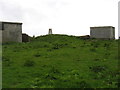
HY50NE 41 stands over a man's height at a little over 2m high and is 50m long by 17m high. Which is over twice the size of all the other mounds, burnt or otherwise, in the area. When under the plough not only burnt material comes up but red stones too.
The presently grass-covered slopes appear gentle to me, but the faintest hint of a crescent face towards the road feels instead like a full stop or something that has had a huge chunk extracted. The rusty gate to the field stands between erect stones. The left one is untypical and marvellously gnarled - could it be antique ?
You may be viewing yesterday's version of this page. To see the most up to date information please register for a free account.
")
")
Do not use the above information on other web sites or publications without permission of the contributor.
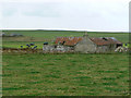
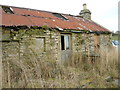
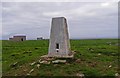
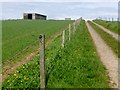
Nearby Images from Geograph Britain and Ireland:
©2006(licence)
©2013(licence)
©2012(licence)
©2015(licence)
©2015(licence)
The above images may not be of the site on this page, they are loaded from Geograph.
Please Submit an Image of this site or go out and take one for us!
Click here to see more info for this site
Nearby sites
Key: Red: member's photo, Blue: 3rd party photo, Yellow: other image, Green: no photo - please go there and take one, Grey: site destroyed
Download sites to:
KML (Google Earth)
GPX (GPS waypoints)
CSV (Garmin/Navman)
CSV (Excel)
To unlock full downloads you need to sign up as a Contributory Member. Otherwise downloads are limited to 50 sites.
Turn off the page maps and other distractions
Nearby sites listing. In the following links * = Image available
277m NE 52° Koffer Howe* Artificial Mound (HY56920699)
911m SSE 153° Howan Blo* Cist (HY571060)
1.9km WSW 248° Eves Howe* Broch or Nuraghe (HY54900611)
2.2km ESE 103° Deerness Broch or Nuraghe (HY588063)
2.3km WSW 257° Hurnip's Point* Chambered Cairn (HY54480634)
2.5km ESE 121° The Howie* Ancient Village or Settlement (HY58850550)
2.5km ENE 75° Riggan of Kami* Broch or Nuraghe (HY59170743)
2.8km SSE 164° Newark (Orkney)* Souterrain (Fogou, Earth House) (HY57460413)
3.1km SSE 154° Howe o' Backland* Broch or Nuraghe (HY58040402)
3.1km S 181° Mussaquoy* Artificial Mound (HY56590369)
3.4km NE 55° Brough of Deerness* Promontory Fort / Cliff Castle (HY59550873)
3.6km SSW 201° Sandaiken* Ancient Village or Settlement (HY55380346)
3.8km SW 232° St. Peter's Bay Mound* Broch or Nuraghe (HY537045)
3.8km SW 223° Comely* Cairn (HY54040403)
3.9km NW 326° The Brough* Ancient Village or Settlement (HY545101)
4.0km SW 228° Campston Cairn* Cairn (HY537042)
4.0km SSW 208° Dingieshowe* Ancient Village or Settlement (HY54760330)
4.0km SW 229° St. Peter's Kirk* Ancient Village or Settlement (HY536042)
4.1km NW 326° Castle of Hangie Bay* Stone Fort or Dun (HY54461022)
4.1km SSW 208° Peerie Howe* Ancient Village or Settlement (HY54750324)
4.2km WNW 303° Taing of Beeman* Ancient Village or Settlement (HY53210914)
4.7km SW 234° Campston (Toab)* Broch or Nuraghe (HY528041)
4.8km W 259° Breck Farm* Standing Stones (HY520060)
4.8km W 275° Loch of Messigate* Standing Stones (HY519073)
5.0km W 268° Muckle Crofty* Stone Row / Alignment (HY517067)
View more nearby sites and additional images


 We would like to know more about this location. Please feel free to add a brief description and any relevant information in your own language.
 Wir möchten mehr über diese Stätte erfahren. Bitte zögern Sie nicht, eine kurze Beschreibung und relevante Informationen in Deutsch hinzuzufügen.
 Nous aimerions en savoir encore un peu sur les lieux. S'il vous plaît n'hesitez pas à ajouter une courte description et tous les renseignements pertinents dans votre propre langue.
 Quisieramos informarnos un poco más de las lugares. No dude en añadir una breve descripción y otros datos relevantes en su propio idioma.