


<< Our Photo Pages >> Pen Hill Longbarrow - Long Barrow in England in Somerset
Submitted by thecaptain on Monday, 11 September 2006 Page Views: 12977
Neolithic and Bronze AgeSite Name: Pen Hill LongbarrowCountry: England County: Somerset Type: Long Barrow
Nearest Town: Wells Nearest Village: Priddy
Map Ref: ST563487
Latitude: 51.235799N Longitude: 2.627322W
Condition:
| 5 | Perfect |
| 4 | Almost Perfect |
| 3 | Reasonable but with some damage |
| 2 | Ruined but still recognisable as an ancient site |
| 1 | Pretty much destroyed, possibly visible as crop marks |
| 0 | No data. |
| -1 | Completely destroyed |
| 5 | Superb |
| 4 | Good |
| 3 | Ordinary |
| 2 | Not Good |
| 1 | Awful |
| 0 | No data. |
| 5 | Can be driven to, probably with disabled access |
| 4 | Short walk on a footpath |
| 3 | Requiring a bit more of a walk |
| 2 | A long walk |
| 1 | In the middle of nowhere, a nightmare to find |
| 0 | No data. |
| 5 | co-ordinates taken by GPS or official recorded co-ordinates |
| 4 | co-ordinates scaled from a detailed map |
| 3 | co-ordinates scaled from a bad map |
| 2 | co-ordinates of the nearest village |
| 1 | co-ordinates of the nearest town |
| 0 | no data |
Internal Links:
External Links:
I have visited· I would like to visit
TheCaptain has visited here
")
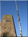
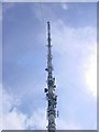
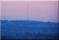
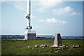
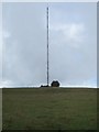
The hill is impossible to miss, as it has on top of it the massive Priddy TV transmitter tower, some of the stay cables of which cross the longbarrow before being anchored into the hillside just below the barrow.
At the eastern end of the barrow is a seperate round barrow, which at first seems to be a part of the longbarrow, which would have made it about 65 metres long.
The views to the south and west from here are fantastic, with the Somerset Levels spread out below to the south with the unmistakeable outline of Glastonbury Tor in the middle of everything. To the west, the setting sun can be seen shining on the Bristol Channel with Brent Knoll standing proud of all around it, and Exmoor and the Quantock Hills beyond.
For more details, see here.
You may be viewing yesterday's version of this page. To see the most up to date information please register for a free account.
")
")
")
")
Do not use the above information on other web sites or publications without permission of the contributor.
Nearby Images from Geograph Britain and Ireland:
©2005(licence)
©2008(licence)
©2011(licence)
©2020(licence)
©2014(licence)
The above images may not be of the site on this page, they are loaded from Geograph.
Please Submit an Image of this site or go out and take one for us!
Click here to see more info for this site
Nearby sites
Key: Red: member's photo, Blue: 3rd party photo, Yellow: other image, Green: no photo - please go there and take one, Grey: site destroyed
Download sites to:
KML (Google Earth)
GPX (GPS waypoints)
CSV (Garmin/Navman)
CSV (Excel)
To unlock full downloads you need to sign up as a Contributory Member. Otherwise downloads are limited to 50 sites.
Turn off the page maps and other distractions
Nearby sites listing. In the following links * = Image available
1.2km NNW 340° Drove Cottage Henge* Henge (ST559498)
1.5km NNW 344° Hunter's Lodge Inn Barrow* Round Barrow(s) (ST559501)
2.7km NW 319° Fair Lady Well* Holy Well or Sacred Spring (ST54515079)
3.0km SSW 203° Wells and Mendip Museum* Museum (ST551459)
3.1km SSW 202° Wells Cathedral* Early Christian Sculptured Stone (ST5514645865)
3.1km SSW 200° St Andrew's Well (Wells)* Holy Well or Sacred Spring (ST5522745824)
3.1km S 170° King's Castle (Wells) Ancient Village or Settlement (ST568456)
3.1km WSW 256° Badger Hole (Somerset) Cave or Rock Shelter (ST53244795)
3.2km WSW 257° Wookey Hole Caves* Cave or Rock Shelter (ST53194801)
3.3km SSW 199° Glastonbury Tor milestone at Wells* Modern Stone Circle etc (ST552456)
3.3km WSW 252° Wookey Hole Caves Museum* Museum (ST531477)
3.5km E 83° Whitnell Corner Barrows* Barrow Cemetery (ST5982849096)
3.7km NW 319° Priddy Nine Barrows* Barrow Cemetery (ST53925149)
4.1km NW 324° Ashen Hill Barrows* Barrow Cemetery (ST53905205)
4.2km NNW 335° Castle Farm Long Barrow* Long Barrow (ST54525255)
4.5km W 270° Deerleap Stones* Standing Stones (ST51804876)
4.5km NNW 328° Priddy Circles S* Henge (ST53945255)
4.6km NW 306° Priddy Church Barrows* Barrow Cemetery (ST526514)
4.6km SE 134° Crapnell Stone Circle (ST596455)
4.7km NNW 330° Priddy Circles C* Henge (ST54015279)
4.7km NNW 330° Priddy Circles* Henge (ST54005280)
4.8km NNW 332° Priddy Circles N* Henge (ST54095302)
4.9km ESE 107° Maesbury Castle* Hillfort (ST610472)
5.3km NNW 336° Priddy Circles Unfinished N* Henge (ST54215355)
5.4km WNW 294° Priddy long barrow* Long Barrow (ST5141550915)
View more nearby sites and additional images


 We would like to know more about this location. Please feel free to add a brief description and any relevant information in your own language.
 Wir möchten mehr über diese Stätte erfahren. Bitte zögern Sie nicht, eine kurze Beschreibung und relevante Informationen in Deutsch hinzuzufügen.
 Nous aimerions en savoir encore un peu sur les lieux. S'il vous plaît n'hesitez pas à ajouter une courte description et tous les renseignements pertinents dans votre propre langue.
 Quisieramos informarnos un poco más de las lugares. No dude en añadir una breve descripción y otros datos relevantes en su propio idioma.