

<< Our Photo Pages >> Drove Cottage Henge - Henge in England in Somerset
Submitted by thecaptain on Sunday, 21 July 2002 Page Views: 12015
Neolithic and Bronze AgeSite Name: Drove Cottage Henge Alternative Name: Hunters Lodge Inn HengeCountry: England County: Somerset Type: Henge
Nearest Town: Wells Nearest Village: Priddy
Map Ref: ST559498 Landranger Map Number: 182
Latitude: 51.245658N Longitude: 2.633187W
Condition:
| 5 | Perfect |
| 4 | Almost Perfect |
| 3 | Reasonable but with some damage |
| 2 | Ruined but still recognisable as an ancient site |
| 1 | Pretty much destroyed, possibly visible as crop marks |
| 0 | No data. |
| -1 | Completely destroyed |
| 5 | Superb |
| 4 | Good |
| 3 | Ordinary |
| 2 | Not Good |
| 1 | Awful |
| 0 | No data. |
| 5 | Can be driven to, probably with disabled access |
| 4 | Short walk on a footpath |
| 3 | Requiring a bit more of a walk |
| 2 | A long walk |
| 1 | In the middle of nowhere, a nightmare to find |
| 0 | No data. |
| 5 | co-ordinates taken by GPS or official recorded co-ordinates |
| 4 | co-ordinates scaled from a detailed map |
| 3 | co-ordinates scaled from a bad map |
| 2 | co-ordinates of the nearest village |
| 1 | co-ordinates of the nearest town |
| 0 | no data |
Internal Links:
External Links:
I have visited· I would like to visit
TheCaptain has visited here
")
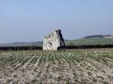
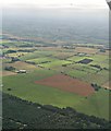
The earthworks can clearly be seen in the field, but without proper access to the field, it was difficult to fully make out what is there.
The banks and ditch seem quite wide, but not very high or deep, and it would appear to have a mound in the centre. The entrance is at the northern side.
For further information see here.
You may be viewing yesterday's version of this page. To see the most up to date information please register for a free account.
")
")
")
Do not use the above information on other web sites or publications without permission of the contributor.
Nearby Images from Geograph Britain and Ireland:
©2018(licence)
©2010(licence)
©2018(licence)
©2009(licence)
©2019(licence)
The above images may not be of the site on this page, they are loaded from Geograph.
Please Submit an Image of this site or go out and take one for us!
Click here to see more info for this site
Nearby sites
Key: Red: member's photo, Blue: 3rd party photo, Yellow: other image, Green: no photo - please go there and take one, Grey: site destroyed
Download sites to:
KML (Google Earth)
GPX (GPS waypoints)
CSV (Garmin/Navman)
CSV (Excel)
To unlock full downloads you need to sign up as a Contributory Member. Otherwise downloads are limited to 50 sites.
Turn off the page maps and other distractions
Nearby sites listing. In the following links * = Image available
300m N 360° Hunter's Lodge Inn Barrow* Round Barrow(s) (ST559501)
1.2km SSE 160° Pen Hill Longbarrow* Long Barrow (ST563487)
1.7km NW 305° Fair Lady Well* Holy Well or Sacred Spring (ST54515079)
2.6km NW 310° Priddy Nine Barrows* Barrow Cemetery (ST53925149)
3.0km NW 318° Ashen Hill Barrows* Barrow Cemetery (ST53905205)
3.1km NNW 333° Castle Farm Long Barrow* Long Barrow (ST54525255)
3.2km SW 235° Badger Hole (Somerset) Cave or Rock Shelter (ST53244795)
3.2km SW 236° Wookey Hole Caves* Cave or Rock Shelter (ST53194801)
3.4km NW 324° Priddy Circles S* Henge (ST53945255)
3.5km SW 233° Wookey Hole Caves Museum* Museum (ST531477)
3.5km NNW 327° Priddy Circles C* Henge (ST54015279)
3.5km NNW 327° Priddy Circles* Henge (ST54005280)
3.7km WNW 295° Priddy Church Barrows* Barrow Cemetery (ST526514)
3.7km NNW 330° Priddy Circles N* Henge (ST54095302)
4.0km E 100° Whitnell Corner Barrows* Barrow Cemetery (ST5982849096)
4.0km S 191° Wells and Mendip Museum* Museum (ST551459)
4.0km S 190° Wells Cathedral* Early Christian Sculptured Stone (ST5514645865)
4.0km S 189° St Andrew's Well (Wells)* Holy Well or Sacred Spring (ST5522745824)
4.1km NNW 335° Priddy Circles Unfinished N* Henge (ST54215355)
4.2km WSW 255° Deerleap Stones* Standing Stones (ST51804876)
4.3km S 189° Glastonbury Tor milestone at Wells* Modern Stone Circle etc (ST552456)
4.3km SSE 167° King's Castle (Wells) Ancient Village or Settlement (ST568456)
4.6km WNW 284° Priddy long barrow* Long Barrow (ST5141550915)
4.7km WNW 293° Townsend Farm Barrow Cemetery* Barrow Cemetery (ST5152851658)
4.9km NNW 333° Pool Farm Cist* Rock Art (ST53745415)
View more nearby sites and additional images


 We would like to know more about this location. Please feel free to add a brief description and any relevant information in your own language.
 Wir möchten mehr über diese Stätte erfahren. Bitte zögern Sie nicht, eine kurze Beschreibung und relevante Informationen in Deutsch hinzuzufügen.
 Nous aimerions en savoir encore un peu sur les lieux. S'il vous plaît n'hesitez pas à ajouter une courte description et tous les renseignements pertinents dans votre propre langue.
 Quisieramos informarnos un poco más de las lugares. No dude en añadir una breve descripción y otros datos relevantes en su propio idioma.