

<< Our Photo Pages >> Tower of Clett - Artificial Mound in Scotland in Orkney
Submitted by howar on Tuesday, 02 January 2007 Page Views: 4205
Multi-periodSite Name: Tower of Clett Alternative Name: Rami Geo, Holm Battery, GraemeshallCountry: Scotland County: Orkney Type: Artificial Mound
Nearest Town: Kirkwall Nearest Village: St. Mary's
Map Ref: HY4949701654
Latitude: 58.899224N Longitude: 2.878203W
Condition:
| 5 | Perfect |
| 4 | Almost Perfect |
| 3 | Reasonable but with some damage |
| 2 | Ruined but still recognisable as an ancient site |
| 1 | Pretty much destroyed, possibly visible as crop marks |
| 0 | No data. |
| -1 | Completely destroyed |
| 5 | Superb |
| 4 | Good |
| 3 | Ordinary |
| 2 | Not Good |
| 1 | Awful |
| 0 | No data. |
| 5 | Can be driven to, probably with disabled access |
| 4 | Short walk on a footpath |
| 3 | Requiring a bit more of a walk |
| 2 | A long walk |
| 1 | In the middle of nowhere, a nightmare to find |
| 0 | No data. |
| 5 | co-ordinates taken by GPS or official recorded co-ordinates |
| 4 | co-ordinates scaled from a detailed map |
| 3 | co-ordinates scaled from a bad map |
| 2 | co-ordinates of the nearest village |
| 1 | co-ordinates of the nearest town |
| 0 | no data |
Internal Links:
External Links:
")
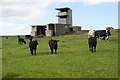
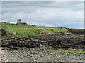
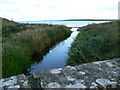
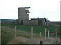
RCAHMS NMRS record no. HY40SE 10 is a burnt mound of stones and earth only a couple of metres across dated by Hedges [TL specimens rather than a full excavation] to the Middle Bronze Age, an early date for Orkney, and it was used for a short period compared to other burnt mounds. Coming through St.Mary's from Kirkwall instead of turning on to the Churchill Barriers carry on past Graemeshall. At the bottom of the hill the mound of Mass Howe is at the coast on your right. There is a new coastal path at the base of this. The first few yards are a bit skewhiff, thereafter it is a little narrow and you need to watch out for tussocks of grass and small holes. Leaving Mass Howe you see the WWII buildings and the burnt mound is in the same field. Just past the buildings there is a long heap of large stones and rocks and fragments marking the well-spring. To its right the small mound you can see is the site The main part of the burnt mound is somewhat over two metres across and reasonably level despite the slight scoop of excavation on the downhill portion, with a few middling stones and quite a number of flattish burnt stones in various hues. Close up I see that this central portion is probably less than the whole. Downhill there is a steeper slope to it (with at least one slightly projecting orthostat by the base) and behind it a long tail. Tempted to call it tadpole-shaped but its really more of a ramp, reminding me of a very tiny Hawell with most of the stone gone.
You may be viewing yesterday's version of this page. To see the most up to date information please register for a free account.
")
")
")
Do not use the above information on other web sites or publications without permission of the contributor.
Nearby Images from Geograph Britain and Ireland:
©2013(licence)
©2021(licence)
©2018(licence)
©2006(licence)
©2006(licence)
The above images may not be of the site on this page, they are loaded from Geograph.
Please Submit an Image of this site or go out and take one for us!
Click here to see more info for this site
Nearby sites
Key: Red: member's photo, Blue: 3rd party photo, Yellow: other image, Green: no photo - please go there and take one, Grey: site destroyed
Download sites to:
KML (Google Earth)
GPX (GPS waypoints)
CSV (Garmin/Navman)
CSV (Excel)
To unlock full downloads you need to sign up as a Contributory Member. Otherwise downloads are limited to 50 sites.
Turn off the page maps and other distractions
Nearby sites listing. In the following links * = Image available
435m WNW 290° Mass Howe* Misc. Earthwork (HY49090181)
722m NNW 343° Crearhowe* Artificial Mound (HY49300235)
1.4km NW 310° Hall of Gorn* Round Barrow(s) (HY484026)
1.5km NW 306° Laughton's Knowe* Round Barrow(s) (HY48260258)
1.6km SW 223° Lamb Holm* Ancient Village or Settlement (HY484005)
1.8km SE 124° St. Nicholas Church* Ancient Village or Settlement (HY510006)
2.3km SE 125° Castle Howe (Orkney)* Ancient Village or Settlement (HY514003)
2.5km W 263° St Mary's Broch* Broch or Nuraghe (HY470014)
2.7km NW 306° Holm Chambered Tomb* Chambered Tomb (HY473033)
2.9km S 191° Northfield Broch* Broch or Nuraghe (ND489988)
3.3km WNW 301° Gutterpool* Misc. Earthwork (HY467034)
4.0km SE 135° Rose Ness* Chambered Cairn (ND5228698813)
4.0km SE 128° Roseness* Chambered Cairn (ND52629917)
4.1km NE 53° Campston (Toab)* Broch or Nuraghe (HY528041)
4.4km E 82° The Cairn* Artificial Mound (HY53840223)
4.4km NNE 15° Burn of Langskaill* Ancient Village or Settlement (HY507059)
4.4km N 10° Brymer* Round Barrow(s) (HY503060)
4.4km NNE 16° Round Howe* Broch or Nuraghe (HY50780591)
4.6km NNE 17° Long Howe* Long Barrow (HY509060)
4.6km NNE 19° Mine Howe* Chambered Cairn (HY5106406023)
4.7km E 80° Stembister farm stone* Standing Stone (Menhir) (HY54130239)
4.8km NNE 20° Longhowe Cairn (HY512061)
4.8km NNE 18° Stem Howe* Round Barrow(s) (HY510062)
4.8km ENE 57° St. Peter's Kirk* Ancient Village or Settlement (HY536042)
4.8km NW 310° Mark Stone of Gaitnip* Standing Stone (Menhir) (HY458048)
View more nearby sites and additional images


 We would like to know more about this location. Please feel free to add a brief description and any relevant information in your own language.
 Wir möchten mehr über diese Stätte erfahren. Bitte zögern Sie nicht, eine kurze Beschreibung und relevante Informationen in Deutsch hinzuzufügen.
 Nous aimerions en savoir encore un peu sur les lieux. S'il vous plaît n'hesitez pas à ajouter une courte description et tous les renseignements pertinents dans votre propre langue.
 Quisieramos informarnos un poco más de las lugares. No dude en añadir una breve descripción y otros datos relevantes en su propio idioma.