


<< Our Photo Pages >> Craw Howe - Cairn in Scotland in Orkney
Submitted by howar on Sunday, 28 March 2004 Page Views: 5088
Neolithic and Bronze AgeSite Name: Craw HoweCountry: Scotland
NOTE: This site is 0.3 km away from the location you searched for.
County: Orkney Type: Cairn
Nearest Town: Kirkwall
Map Ref: HY491069 Landranger Map Number: 6
Latitude: 58.946283N Longitude: 2.886298W
Condition:
| 5 | Perfect |
| 4 | Almost Perfect |
| 3 | Reasonable but with some damage |
| 2 | Ruined but still recognisable as an ancient site |
| 1 | Pretty much destroyed, possibly visible as crop marks |
| 0 | No data. |
| -1 | Completely destroyed |
| 5 | Superb |
| 4 | Good |
| 3 | Ordinary |
| 2 | Not Good |
| 1 | Awful |
| 0 | No data. |
| 5 | Can be driven to, probably with disabled access |
| 4 | Short walk on a footpath |
| 3 | Requiring a bit more of a walk |
| 2 | A long walk |
| 1 | In the middle of nowhere, a nightmare to find |
| 0 | No data. |
| 5 | co-ordinates taken by GPS or official recorded co-ordinates |
| 4 | co-ordinates scaled from a detailed map |
| 3 | co-ordinates scaled from a bad map |
| 2 | co-ordinates of the nearest village |
| 1 | co-ordinates of the nearest town |
| 0 | no data |
Internal Links:
External Links:
")
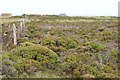
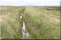
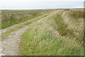
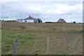
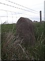
Near the airport but one for the yompers this . Essayed it on the way back from Mine Howe. Coming from this direction I tried the field to the left of the cottage but found it to be waterlogged ground crisscrossed by ground water. So I made it through the waste ground to the right. Still one for the welly brigade perhaps as there was boggy bits and the very rough pasture on the way consists of large tussocks jostling for position. Not much further down the road is a Nissen hut and I would advise visitors to go by the track alongside this and the strike across for the howe.
Craw Howe is the mound just behind the pool extending to the fence crossing the right-hand end. Maybe the two other mounds are part of the hill one sees too. Probably not really worth all that effort as very little sense can be made of it. There are obvious signs of prior excavation/s and some of the stones on top are of recent origin.
You may be viewing yesterday's version of this page. To see the most up to date information please register for a free account.
Do not use the above information on other web sites or publications without permission of the contributor.
Nearby Images from Geograph Britain and Ireland:
©2019(licence)
©2019(licence)
©2019(licence)
©2015(licence)
©2019(licence)
The above images may not be of the site on this page, they are loaded from Geograph.
Please Submit an Image of this site or go out and take one for us!
Click here to see more info for this site
Nearby sites
Key: Red: member's photo, Blue: 3rd party photo, Yellow: other image, Green: no photo - please go there and take one, Grey: site destroyed
Download sites to:
KML (Google Earth)
GPX (GPS waypoints)
CSV (Garmin/Navman)
CSV (Excel)
To unlock full downloads you need to sign up as a Contributory Member. Otherwise downloads are limited to 50 sites.
Turn off the page maps and other distractions
Nearby sites listing. In the following links * = Image available
772m W 275° Staneloof* Cairn (HY48330698)
1.5km WSW 250° Heathery Howes* Round Barrow(s) (HY477064)
1.5km SE 126° Brymer* Round Barrow(s) (HY503060)
1.7km E 93° Nearhouse* Ancient Village or Settlement (HY508068)
1.9km ESE 121° Burn of Langskaill* Ancient Village or Settlement (HY507059)
1.9km ESE 120° Round Howe* Broch or Nuraghe (HY50780591)
2.0km ESE 116° Long Howe* Long Barrow (HY509060)
2.0km ESE 109° Stem Howe* Round Barrow(s) (HY510062)
2.1km E 100° Hawell Burnt Mound* Round Barrow(s) (HY512065)
2.1km ESE 113° Mine Howe* Chambered Cairn (HY5106406023)
2.2km ESE 110° Longhowe Cairn (HY512061)
2.4km NW 311° Grimsquoy* Round Barrow(s) (HY473085)
2.5km ENE 63° Mill Sand* Standing Stones (HY513080)
2.6km NE 51° Whitecleat* Holy Well or Sacred Spring (HY511085)
2.6km E 94° Muckle Crofty* Stone Row / Alignment (HY517067)
2.8km E 81° Loch of Messigate* Standing Stones (HY519073)
3.0km ESE 107° Breck Farm* Standing Stones (HY520060)
3.1km NE 47° The Howie of The Manse* Broch or Nuraghe (HY514090)
3.4km NW 319° Tower Hill (Orkney)* Round Barrow(s) (HY469095)
3.5km WSW 243° The Five Hillocks* Barrow Cemetery (HY45980536)
3.5km NNW 332° Berstane Broch* Broch or Nuraghe (HY475100)
3.7km NE 55° Grieves Cottage* Standing Stone (Menhir) (HY522090)
3.8km NNE 26° Yinstay* Ancient Village or Settlement (HY50841031)
3.9km WSW 237° Mark Stone of Gaitnip* Standing Stone (Menhir) (HY458048)
3.9km NE 51° Loch of Tankerness* Ancient Village or Settlement (HY522093)
View more nearby sites and additional images


 We would like to know more about this location. Please feel free to add a brief description and any relevant information in your own language.
 Wir möchten mehr über diese Stätte erfahren. Bitte zögern Sie nicht, eine kurze Beschreibung und relevante Informationen in Deutsch hinzuzufügen.
 Nous aimerions en savoir encore un peu sur les lieux. S'il vous plaît n'hesitez pas à ajouter une courte description et tous les renseignements pertinents dans votre propre langue.
 Quisieramos informarnos un poco más de las lugares. No dude en añadir una breve descripción y otros datos relevantes en su propio idioma.