

<< Our Photo Pages >> Jenny's Well - Holy Well or Sacred Spring in Scotland in Moray
Submitted by KiwiBetsy on Tuesday, 12 September 2006 Page Views: 13930
Springs and Holy WellsSite Name: Jenny's Well Alternative Name: Janet's WellCountry: Scotland
NOTE: This site is 2.6 km away from the location you searched for.
County: Moray Type: Holy Well or Sacred Spring
Nearest Town: Portknockie
Map Ref: NJ495682
Latitude: 57.700762N Longitude: 2.848947W
Condition:
| 5 | Perfect |
| 4 | Almost Perfect |
| 3 | Reasonable but with some damage |
| 2 | Ruined but still recognisable as an ancient site |
| 1 | Pretty much destroyed, possibly visible as crop marks |
| 0 | No data. |
| -1 | Completely destroyed |
| 5 | Superb |
| 4 | Good |
| 3 | Ordinary |
| 2 | Not Good |
| 1 | Awful |
| 0 | No data. |
| 5 | Can be driven to, probably with disabled access |
| 4 | Short walk on a footpath |
| 3 | Requiring a bit more of a walk |
| 2 | A long walk |
| 1 | In the middle of nowhere, a nightmare to find |
| 0 | No data. |
| 5 | co-ordinates taken by GPS or official recorded co-ordinates |
| 4 | co-ordinates scaled from a detailed map |
| 3 | co-ordinates scaled from a bad map |
| 2 | co-ordinates of the nearest village |
| 1 | co-ordinates of the nearest town |
| 0 | no data |
Internal Links:
External Links:
")
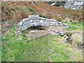
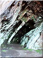
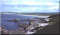
To find Jenny’s Well join the coastal path in Portknockie, near Bow Fiddle Rock, and follow it towards Cullen. A short distance after descending to sea level and before the sandy beach, Jenny’s Well is on the right.
You may be viewing yesterday's version of this page. To see the most up to date information please register for a free account.
Do not use the above information on other web sites or publications without permission of the contributor.
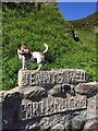
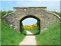
Nearby Images from Geograph Britain and Ireland:
©2021(licence)
©2021(licence)
©2020(licence)
©2006(licence)
©2009(licence)
The above images may not be of the site on this page, they are loaded from Geograph.
Please Submit an Image of this site or go out and take one for us!
Click here to see more info for this site
Nearby sites
Key: Red: member's photo, Blue: 3rd party photo, Yellow: other image, Green: no photo - please go there and take one, Grey: site destroyed
Download sites to:
KML (Google Earth)
GPX (GPS waypoints)
CSV (Garmin/Navman)
CSV (Excel)
To unlock full downloads you need to sign up as a Contributory Member. Otherwise downloads are limited to 50 sites.
Turn off the page maps and other distractions
Nearby sites listing. In the following links * = Image available
5.9km SE 137° Gaul Cross* Stone Circle (NJ53506387)
6.9km ESE 110° Sandend Bay A Stone Circle (NJ560657)
6.9km ESE 110° Sandend Bay B Cairn (NJ56016571)
9.9km ESE 104° St Comb's Well (Portsoy)* Holy Well or Sacred Spring (NJ591657)
13.3km ESE 122° St. Brandan's Stanes* Stone Circle (NJ60756105)
13.4km WSW 247° Cowiemuir* Stone Circle (NJ37096310)
15.8km SE 146° Thorax* Stone Circle (NJ58225495)
15.9km WSW 257° Browland* Stone Circle (NJ339647)
16.3km SW 236° Bellie Round Barrow(s) (NJ359592)
18.8km ESE 113° St Colme's Well* Holy Well or Sacred Spring (NJ668607)
18.9km ESE 104° Lusy Law* Cairn (NJ67866346)
19.5km ESE 114° Stirling Cairn* Cairn (NJ67296015)
19.5km W 261° Binn Hill* Round Cairn (NJ30166532)
20.1km SSE 147° The White Stone, Whitemuir Farm Natural Stone / Erratic / Other Natural Feature (NJ60125110)
20.2km SSE 163° Rothiemay* Stone Circle (NJ55084872)
20.5km ESE 104° Gavenie Braes* Stone Circle (NJ69386293)
20.6km SSE 150° Marnoch Church* Stone Circle (NJ5970250206)
20.8km SSE 148° Bellman's Wood* Stone Circle (NJ6047150429)
20.9km WSW 258° Innesmill* Stone Circle (NJ28956407)
21.4km S 170° Tillytarmont 2* Class I Pictish Symbol Stone (NJ52974705)
21.5km SW 232° St Mary's Well (Inchberry)* Holy Well or Sacred Spring (NJ323552)
21.7km SSE 166° Kimmonity Stone Circle (NJ54394707)
21.7km SSW 198° Tobar na Cailleach Holy Well or Sacred Spring (NJ4265947528)
22.4km SE 126° North Burreldales* Stone Circle (NJ6759054916)
22.7km SE 125° Newton Of Montblairy Stone Circle (NJ680550)
View more nearby sites and additional images


 We would like to know more about this location. Please feel free to add a brief description and any relevant information in your own language.
 Wir möchten mehr über diese Stätte erfahren. Bitte zögern Sie nicht, eine kurze Beschreibung und relevante Informationen in Deutsch hinzuzufügen.
 Nous aimerions en savoir encore un peu sur les lieux. S'il vous plaît n'hesitez pas à ajouter une courte description et tous les renseignements pertinents dans votre propre langue.
 Quisieramos informarnos un poco más de las lugares. No dude en añadir una breve descripción y otros datos relevantes en su propio idioma.