


<< Our Photo Pages >> Dog Holes - Cave or Rock Shelter in England in Lancashire
Submitted by LivingRocks on Friday, 06 May 2005 Page Views: 14725
Natural PlacesSite Name: Dog HolesCountry: England County: Lancashire Type: Cave or Rock Shelter
Nearest Town: Lancaster Nearest Village: Warton
Map Ref: SD48337303
Latitude: 54.150479N Longitude: 2.792595W
Condition:
| 5 | Perfect |
| 4 | Almost Perfect |
| 3 | Reasonable but with some damage |
| 2 | Ruined but still recognisable as an ancient site |
| 1 | Pretty much destroyed, possibly visible as crop marks |
| 0 | No data. |
| -1 | Completely destroyed |
| 5 | Superb |
| 4 | Good |
| 3 | Ordinary |
| 2 | Not Good |
| 1 | Awful |
| 0 | No data. |
| 5 | Can be driven to, probably with disabled access |
| 4 | Short walk on a footpath |
| 3 | Requiring a bit more of a walk |
| 2 | A long walk |
| 1 | In the middle of nowhere, a nightmare to find |
| 0 | No data. |
| 5 | co-ordinates taken by GPS or official recorded co-ordinates |
| 4 | co-ordinates scaled from a detailed map |
| 3 | co-ordinates scaled from a bad map |
| 2 | co-ordinates of the nearest village |
| 1 | co-ordinates of the nearest town |
| 0 | no data |
Internal Links:
External Links:
I have visited· I would like to visit
SumDoood would like to visit
")
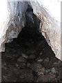
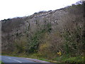
The Dog Holes are entered via a shaft in the limestone pavement which leads to a passage and chambers; there appear to be a number of points in a fissure aprox. 15m long by which the entrance can be accessed, but I did not cross the fence to take a closer look.
Dog Holes has been inhabited over a considerable period of time. Exploration by JW Jackson in 1909-13 recovered quantities of human and animal bones, the former regarded as mainly Neolithic but some possibly later, Neolithic finds included Beaker pottery. The Roman period yielded potsherds, an intaglio brooch, a balance, iron knives, iron slag lumps and whetstones, whilst a hammer stone, bone pins, a bone piercer and a weaving comb are regarded as of Iron Age origin. Bolton museum holds part of a stone axe apparently found on a ledge in the cave along with a chert flake plus human and animal bones.
Access to the site is very easy, however the caves are situated on private land so permission should be sought, and I have no idea who the landowner is. At the time of my visit I entered the area by the only gate which doesn’t have a private sign or lead to a house or farm, so I was actually at the caves before realizing that they were on private property :-)
You may be viewing yesterday's version of this page. To see the most up to date information please register for a free account.
")
Do not use the above information on other web sites or publications without permission of the contributor.
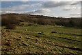
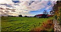
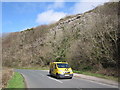
Nearby Images from Geograph Britain and Ireland:
©2008(licence)
©2023(licence)
©2011(licence)
©2009(licence)
©2011(licence)
The above images may not be of the site on this page, they are loaded from Geograph.
Please Submit an Image of this site or go out and take one for us!
Click here to see more info for this site
Nearby sites
Key: Red: member's photo, Blue: 3rd party photo, Yellow: other image, Green: no photo - please go there and take one, Grey: site destroyed
Download sites to:
KML (Google Earth)
GPX (GPS waypoints)
CSV (Garmin/Navman)
CSV (Excel)
To unlock full downloads you need to sign up as a Contributory Member. Otherwise downloads are limited to 50 sites.
Turn off the page maps and other distractions
Nearby sites listing. In the following links * = Image available
234m SW 219° Badger Hole (Lancashire)* Cave or Rock Shelter (SD48187285)
430m W 265° Ings Point Natural Stone / Erratic / Other Natural Feature (SD479730)
928m ESE 110° Warton Crag* Hillfort (SD492727)
1.1km S 186° Cote Stones Cairn (SD482719)
1.3km ENE 67° The Three brothers* Natural Stone / Erratic / Other Natural Feature (SD495735)
1.6km E 87° Warton Crag giant wall Misc. Earthwork (SD499731)
2.2km NE 51° Summerhouse Hill* Modern Stone Circle etc (SD50037437)
2.2km NE 55° Summerhouse Hill Cairn* Cairn (SD50147428)
2.5km SSE 163° Hunting Hill* Round Barrow(s) (SD49037065)
2.5km WNW 292° Woodwell* Holy Well or Sacred Spring (SD4674)
3.4km ENE 62° Yealand ancient stone walls or rows 1 Misc. Earthwork (SD514746)
3.7km NE 52° Yealand ancient stone walls or rows 2 Misc. Earthwork (SD513753)
3.8km NNW 347° Bowk Stone Natural Stone / Erratic / Other Natural Feature (SD475767)
3.9km N 353° Haweswater Cairns and Propped Stone Cairn (SD479769)
4.0km N 352° Haweswater Stones* Misc. Earthwork (SD478770)
4.0km E 92° Manor Farm* Round Barrow(s) (SD52387285)
5.2km S 180° St Michael's Well (Lancashire) Holy Well or Sacred Spring (SD4828567831)
5.4km NNW 348° Hazelslack Stone* Standing Stone (Menhir) (SD473783)
5.4km S 179° Bolton Le Sands Early Christian Sculptured Stone (SD48336765)
5.4km S 172° Bolton-le-Sands Barrow* Ring Cairn (SD4901467624)
6.0km N 4° The Fairy Steps* Natural Stone / Erratic / Other Natural Feature (SD488790)
6.1km NE 50° St James's Church (Burton-in-Kendal) Ancient Cross (SD5305076921)
6.2km NW 323° Grubbins Wood Stone Natural Stone / Erratic / Other Natural Feature (SD446780)
6.3km NNE 13° The Rent Stone* Natural Stone / Erratic / Other Natural Feature (SD498792)
7.1km N 358° The Dog Hole Cave or Rock Shelter (SD482801)
View more nearby sites and additional images


 We would like to know more about this location. Please feel free to add a brief description and any relevant information in your own language.
 Wir möchten mehr über diese Stätte erfahren. Bitte zögern Sie nicht, eine kurze Beschreibung und relevante Informationen in Deutsch hinzuzufügen.
 Nous aimerions en savoir encore un peu sur les lieux. S'il vous plaît n'hesitez pas à ajouter une courte description et tous les renseignements pertinents dans votre propre langue.
 Quisieramos informarnos un poco más de las lugares. No dude en añadir una breve descripción y otros datos relevantes en su propio idioma.