


<< Our Photo Pages >> Badger Hole (Lancashire) - Cave or Rock Shelter in England in Lancashire
Submitted by LivingRocks on Friday, 06 May 2005 Page Views: 10748
Natural PlacesSite Name: Badger Hole (Lancashire)Country: England County: Lancashire Type: Cave or Rock Shelter
Nearest Town: Lancaster Nearest Village: Warton
Map Ref: SD48187285
Latitude: 54.148846N Longitude: 2.79486W
Condition:
| 5 | Perfect |
| 4 | Almost Perfect |
| 3 | Reasonable but with some damage |
| 2 | Ruined but still recognisable as an ancient site |
| 1 | Pretty much destroyed, possibly visible as crop marks |
| 0 | No data. |
| -1 | Completely destroyed |
| 5 | Superb |
| 4 | Good |
| 3 | Ordinary |
| 2 | Not Good |
| 1 | Awful |
| 0 | No data. |
| 5 | Can be driven to, probably with disabled access |
| 4 | Short walk on a footpath |
| 3 | Requiring a bit more of a walk |
| 2 | A long walk |
| 1 | In the middle of nowhere, a nightmare to find |
| 0 | No data. |
| 5 | co-ordinates taken by GPS or official recorded co-ordinates |
| 4 | co-ordinates scaled from a detailed map |
| 3 | co-ordinates scaled from a bad map |
| 2 | co-ordinates of the nearest village |
| 1 | co-ordinates of the nearest town |
| 0 | no data |
Internal Links:
External Links:
I have visited· I would like to visit
SumDoood would like to visit
 (PID:13586)")
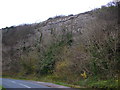
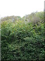
Badger Hole is a small cave no more than 5m long by 3m wide situated about 20m up the west face of Warton Crag. Excavations have uncovered items from a number of eras including Late Upper Paleolithic, and Roman. The earliest finds consisted of stone artifacts but no animal remains.
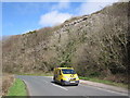
Access is via New Rd from Warton to Silverdale, after passing the caravan park & old lime kiln there is a layby on the right, the cave is found by a short but steep scramble up the bank above the layby.
You may be viewing yesterday's version of this page. To see the most up to date information please register for a free account.
Do not use the above information on other web sites or publications without permission of the contributor.
Nearby Images from Geograph Britain and Ireland:
©2009(licence)
©2011(licence)
©2011(licence)
©2011(licence)
©2015(licence)
The above images may not be of the site on this page, they are loaded from Geograph.
Please Submit an Image of this site or go out and take one for us!
Click here to see more info for this site
Nearby sites
Key: Red: member's photo, Blue: 3rd party photo, Yellow: other image, Green: no photo - please go there and take one, Grey: site destroyed
Download sites to:
KML (Google Earth)
GPX (GPS waypoints)
CSV (Garmin/Navman)
CSV (Excel)
To unlock full downloads you need to sign up as a Contributory Member. Otherwise downloads are limited to 50 sites.
Turn off the page maps and other distractions
Nearby sites listing. In the following links * = Image available
234m NE 39° Dog Holes* Cave or Rock Shelter (SD48337303)
317m WNW 298° Ings Point Natural Stone / Erratic / Other Natural Feature (SD479730)
950m S 178° Cote Stones Cairn (SD482719)
1.0km E 98° Warton Crag* Hillfort (SD492727)
1.5km ENE 63° The Three brothers* Natural Stone / Erratic / Other Natural Feature (SD495735)
1.7km E 81° Warton Crag giant wall Misc. Earthwork (SD499731)
2.4km SSE 158° Hunting Hill* Round Barrow(s) (SD49037065)
2.4km NE 50° Summerhouse Hill* Modern Stone Circle etc (SD50037437)
2.4km NE 53° Summerhouse Hill Cairn* Cairn (SD50147428)
2.5km WNW 297° Woodwell* Holy Well or Sacred Spring (SD4674)
3.7km ENE 61° Yealand ancient stone walls or rows 1 Misc. Earthwork (SD514746)
3.9km N 349° Bowk Stone Natural Stone / Erratic / Other Natural Feature (SD475767)
4.0km NE 51° Yealand ancient stone walls or rows 2 Misc. Earthwork (SD513753)
4.1km N 355° Haweswater Cairns and Propped Stone Cairn (SD479769)
4.2km N 354° Haweswater Stones* Misc. Earthwork (SD478770)
4.2km E 89° Manor Farm* Round Barrow(s) (SD52387285)
5.0km S 178° St Michael's Well (Lancashire) Holy Well or Sacred Spring (SD4828567831)
5.2km S 178° Bolton Le Sands Early Christian Sculptured Stone (SD48336765)
5.3km S 170° Bolton-le-Sands Barrow* Ring Cairn (SD4901467624)
5.5km N 350° Hazelslack Stone* Standing Stone (Menhir) (SD473783)
6.2km N 5° The Fairy Steps* Natural Stone / Erratic / Other Natural Feature (SD488790)
6.3km NW 325° Grubbins Wood Stone Natural Stone / Erratic / Other Natural Feature (SD446780)
6.3km NE 49° St James's Church (Burton-in-Kendal) Ancient Cross (SD5305076921)
6.5km NNE 14° The Rent Stone* Natural Stone / Erratic / Other Natural Feature (SD498792)
7.2km N 360° The Dog Hole Cave or Rock Shelter (SD482801)
View more nearby sites and additional images


 We would like to know more about this location. Please feel free to add a brief description and any relevant information in your own language.
 Wir möchten mehr über diese Stätte erfahren. Bitte zögern Sie nicht, eine kurze Beschreibung und relevante Informationen in Deutsch hinzuzufügen.
 Nous aimerions en savoir encore un peu sur les lieux. S'il vous plaît n'hesitez pas à ajouter une courte description et tous les renseignements pertinents dans votre propre langue.
 Quisieramos informarnos un poco más de las lugares. No dude en añadir una breve descripción y otros datos relevantes en su propio idioma.