

<< Text Pages >> Cairn Ley - Cairn in Scotland in Aberdeenshire
Submitted by vicky on Monday, 26 August 2002 Page Views: 4738
Neolithic and Bronze AgeSite Name: Cairn LeyCountry: Scotland County: Aberdeenshire Type: Cairn
Map Ref: NJ461146 Landranger Map Number: 37
Latitude: 57.218961N Longitude: 2.89415W
Condition:
| 5 | Perfect |
| 4 | Almost Perfect |
| 3 | Reasonable but with some damage |
| 2 | Ruined but still recognisable as an ancient site |
| 1 | Pretty much destroyed, possibly visible as crop marks |
| 0 | No data. |
| -1 | Completely destroyed |
| 5 | Superb |
| 4 | Good |
| 3 | Ordinary |
| 2 | Not Good |
| 1 | Awful |
| 0 | No data. |
| 5 | Can be driven to, probably with disabled access |
| 4 | Short walk on a footpath |
| 3 | Requiring a bit more of a walk |
| 2 | A long walk |
| 1 | In the middle of nowhere, a nightmare to find |
| 0 | No data. |
| 5 | co-ordinates taken by GPS or official recorded co-ordinates |
| 4 | co-ordinates scaled from a detailed map |
| 3 | co-ordinates scaled from a bad map |
| 2 | co-ordinates of the nearest village |
| 1 | co-ordinates of the nearest town |
| 0 | no data |
Be the first person to rate this site - see the 'Contribute!' box in the right hand menu.
Internal Links:
External Links:
Cairn in Aberdeenshire
Have you visited this site? Please add a comment below.
You may be viewing yesterday's version of this page. To see the most up to date information please register for a free account.
Do not use the above information on other web sites or publications without permission of the contributor.
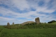
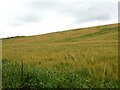
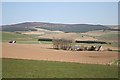
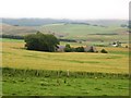
Nearby Images from Geograph Britain and Ireland:
©2008(licence)
©2010(licence)
©2008(licence)
©2008(licence)
©2013(licence)
The above images may not be of the site on this page, they are loaded from Geograph.
Please Submit an Image of this site or go out and take one for us!
Click here to see more info for this site
Nearby sites
Key: Red: member's photo, Blue: 3rd party photo, Yellow: other image, Green: no photo - please go there and take one, Grey: site destroyed
Download sites to:
KML (Google Earth)
GPX (GPS waypoints)
CSV (Garmin/Navman)
CSV (Excel)
To unlock full downloads you need to sign up as a Contributory Member. Otherwise downloads are limited to 50 sites.
Turn off the page maps and other distractions
Nearby sites listing. In the following links * = Image available
360m WNW 303° Cairn Fichley Cairn (NJ458148)
2.0km ESE 108° Lang Stane (Easter Sinnahard)* Standing Stone (Menhir) (NJ48031394)
2.4km WSW 249° Glenkindie* Standing Stone (Menhir) (NJ4382813751)
3.5km ESE 121° Elphillock (Kildrummy) Cairn (NJ49071274)
4.7km W 270° Glenkindie Stone Circle Stone Circle (NJ414147)
4.9km N 7° Lulach's Stone* Standing Stone (Menhir) (NJ4677019421)
5.0km N 359° Kildrummy* Souterrain (Fogou, Earth House) (NJ4608419617)
7.0km WSW 258° Buchaam* Souterrain (Fogou, Earth House) (NJ39261324)
7.2km SSW 202° Tillypronie 2 Class I Pictish Symbol Stone (NJ43250796)
7.3km SSW 203° Tillypronie 1 Class I Pictish Symbol Stone (NJ432079)
8.1km S 190° Milton of Migvie* Souterrain (Fogou, Earth House) (NJ44600668)
8.1km SSW 196° Migvie Cupmarked Stone* Rock Art (NJ4369606817)
8.1km SSW 197° Migvie Stone* Class II Pictish Symbol Stone (NJ4364706823)
8.2km ENE 71° Nether Balfour Multiple Stone Rows / Avenue (NJ539172)
8.2km ENE 71° Nether Balfour Stone Circle (NJ539172)
8.4km SE 136° Holmhead stone circle* Modern Stone Circle etc (NJ51850849)
8.8km SSE 148° Hillhead Stone Circle Stone Circle (NJ50720714)
8.8km SSE 167° Doune Hill Stone Circle (NJ480060)
9.1km S 181° Logie Coldstone Stone Circle (NJ459055)
9.3km S 173° Melgum NW Stone Circle (NJ471053)
9.4km S 173° Melgum Centre* Stone Circle (NJ471052)
9.7km SSW 210° Blue Cairn Circle* Stone Circle (NJ411063)
9.7km S 170° Waulkmill* Stone Circle (NJ47630500)
9.9km S 179° Corrachree* Class I Pictish Symbol Stone (NJ46160470)
10.1km SSE 154° Culsh* Souterrain (Fogou, Earth House) (NJ5048305488)
View more nearby sites and additional images


 We would like to know more about this location. Please feel free to add a brief description and any relevant information in your own language.
 Wir möchten mehr über diese Stätte erfahren. Bitte zögern Sie nicht, eine kurze Beschreibung und relevante Informationen in Deutsch hinzuzufügen.
 Nous aimerions en savoir encore un peu sur les lieux. S'il vous plaît n'hesitez pas à ajouter une courte description et tous les renseignements pertinents dans votre propre langue.
 Quisieramos informarnos un poco más de las lugares. No dude en añadir una breve descripción y otros datos relevantes en su propio idioma.