


<< Our Photo Pages >> Lower Saverock - Not Known (by us) in Scotland in Orkney
Submitted by howar on Sunday, 14 November 2004 Page Views: 5261
Date UncertainSite Name: Lower Saverock Alternative Name: Burn of HatstonCountry: Scotland County: Orkney Type: Not Known (by us)
Nearest Town: Kirkwall
Map Ref: HY43511300
Latitude: 59.000354N Longitude: 2.98499W
Condition:
| 5 | Perfect |
| 4 | Almost Perfect |
| 3 | Reasonable but with some damage |
| 2 | Ruined but still recognisable as an ancient site |
| 1 | Pretty much destroyed, possibly visible as crop marks |
| 0 | No data. |
| -1 | Completely destroyed |
| 5 | Superb |
| 4 | Good |
| 3 | Ordinary |
| 2 | Not Good |
| 1 | Awful |
| 0 | No data. |
| 5 | Can be driven to, probably with disabled access |
| 4 | Short walk on a footpath |
| 3 | Requiring a bit more of a walk |
| 2 | A long walk |
| 1 | In the middle of nowhere, a nightmare to find |
| 0 | No data. |
| 5 | co-ordinates taken by GPS or official recorded co-ordinates |
| 4 | co-ordinates scaled from a detailed map |
| 3 | co-ordinates scaled from a bad map |
| 2 | co-ordinates of the nearest village |
| 1 | co-ordinates of the nearest town |
| 0 | no data |
Internal Links:
External Links:
")
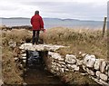
Here the burn is bridged by two immense slabs (the nearer 2.2x0.4x0.25m, the furthest 2.5x0.8x0.3m wide) with a reasonable 2.8m gap in between that includes at least one more stone section along one side. On the right-hand side a lovely white drystane wall lines the burn but on the other side there is nothing but a few sandy stones in the bank until the bridge is reached (though a finger of sod and earth about the height of the wall projects out into the burn from it). Passing strange. The remains of a few large timbers can be seen betwixt and between the slabs and the bridge is wall-lined either side. On the landward side it is 0.9m between the bridge walls, they are 1m high but the bedrock that the bridge sits on accounts for 0.2m of that on the left. A later visit shows the main body of the bridge precedes the possibly early industrial features.
By the new ferry terminal I climbed down to the shore. Passing along the shore I saw the other side of the 'bridge' where the burn meets the coast. It is quite magnificent, the aspect megalithic shining through. If it were not for the timbers I would have no hesitation in saying it is Iron Age at the latest. This side on the left of the waterway there is something reminiscent of a guard cell 1.2x0.8x0.9m beneath the 'bridge', but only having two sides it is more of a full-height niche I suppose. Shoreside the passage is 1.2x1.1m, the walling either side extends 1.3m and it is possible there is a RH projection from the base of 1.8m (including beyond the tumble a stone 1m long). There is much rubble of varying ages to the sides, in front of the passage the water makes a small but deep pool which could well indicate an old ground level or simply the original stream bed's continuance.
Could it be that the timbers were inserted later to make the crossing level, possibly at the same time the area between the two sections of burn was covered over ? Though it could still be the remains of a sea-wall sluice, grander and in better preservation than the one downstream of Tankerness Mill, the size of the bridging roof stones would still incline me to see this as re-use (the sluices shown on the O.S. below the main road are purely modern as it turns out).
You may be viewing yesterday's version of this page. To see the most up to date information please register for a free account.
")
")
")
")
Do not use the above information on other web sites or publications without permission of the contributor.
Nearby Images from Geograph Britain and Ireland:
©2011(licence)
©2014(licence)
©2016(licence)
©2011(licence)

©2023(licence)
The above images may not be of the site on this page, they are loaded from Geograph.
Please Submit an Image of this site or go out and take one for us!
Click here to see more info for this site
Nearby sites
Key: Red: member's photo, Blue: 3rd party photo, Yellow: other image, Green: no photo - please go there and take one, Grey: site destroyed
Download sites to:
KML (Google Earth)
GPX (GPS waypoints)
CSV (Garmin/Navman)
CSV (Excel)
To unlock full downloads you need to sign up as a Contributory Member. Otherwise downloads are limited to 50 sites.
Turn off the page maps and other distractions
Nearby sites listing. In the following links * = Image available
202m S 188° Saverock (2)* Ancient Village or Settlement (HY43481280)
1.4km NW 306° Ramberry Cairn Chambered Cairn (HY42401383)
1.5km SSE 151° Grain Earth House* Souterrain (Fogou, Earth House) (HY442117)
1.8km W 266° Quanterness* Chambered Cairn (HY417129)
1.8km WSW 240° Wideford Hill Cairn* Cairn (HY419121)
1.9km SSE 162° Pickaquoy* Ancient Village or Settlement (HY44071116)
2.3km WSW 238° Heathfield Chambered Cairn (HY415118)
2.4km SE 141° Kirkwall Sculptured Stone (HY450111)
2.5km SSE 147° Tankerness House Museum* Museum (HY44851086)
2.5km SSE 149° The Orkney Museum* Museum (HY448108)
2.6km SE 145° Kirkwall Sculptured Stone (HY44941087)
2.7km WSW 250° Wideford Hill* Chambered Cairn (HY40901211)
3.6km WSW 237° Smerquoy ancient settlement* Ancient Village or Settlement (HY40501109)
3.8km W 263° Rennibister Souterrain* Souterrain (Fogou, Earth House) (HY39731260)
3.8km S 182° Nevada Cott* Artificial Mound (HY433092)
4.0km S 172° Crantit* Souterrain (Fogou, Earth House) (HY440090)
4.2km SSE 163° Scapa* Barrow Cemetery (HY447090)
4.2km S 179° Broch of Lingro* Broch or Nuraghe (HY435088)
4.4km S 183° Lingrow* Chambered Tomb (HY43240863)
4.5km W 267° Ingshowe* Broch or Nuraghe (HY390128)
4.6km WSW 254° Nabban* Holy Well or Sacred Spring (HY391118)
4.6km NE 44° Twi Ness* Cairn (HY46761625)
4.6km SSE 164° Hillhead* Ancient Village or Settlement (HY44720855)
4.7km W 279° Site C Circular Feature from the Rising Tide project Standing Stones (HY3882313776)
4.9km SE 135° Tower Hill (Orkney)* Round Barrow(s) (HY469095)
View more nearby sites and additional images


 We would like to know more about this location. Please feel free to add a brief description and any relevant information in your own language.
 Wir möchten mehr über diese Stätte erfahren. Bitte zögern Sie nicht, eine kurze Beschreibung und relevante Informationen in Deutsch hinzuzufügen.
 Nous aimerions en savoir encore un peu sur les lieux. S'il vous plaît n'hesitez pas à ajouter une courte description et tous les renseignements pertinents dans votre propre langue.
 Quisieramos informarnos un poco más de las lugares. No dude en añadir una breve descripción y otros datos relevantes en su propio idioma.