


<< Our Photo Pages >> Troutbeck Park Round Cairn 1 - Round Cairn in England in Cumbria
Submitted by MonumentMan on Monday, 15 June 2020 Page Views: 698
Neolithic and Bronze AgeSite Name: Troutbeck Park Round Cairn 1Country: England County: Cumbria Type: Round Cairn
Nearest Town: Ambleside Nearest Village: Troutbeck
Map Ref: NY4248407616
Latitude: 54.460650N Longitude: 2.888762W
Condition:
| 5 | Perfect |
| 4 | Almost Perfect |
| 3 | Reasonable but with some damage |
| 2 | Ruined but still recognisable as an ancient site |
| 1 | Pretty much destroyed, possibly visible as crop marks |
| 0 | No data. |
| -1 | Completely destroyed |
| 5 | Superb |
| 4 | Good |
| 3 | Ordinary |
| 2 | Not Good |
| 1 | Awful |
| 0 | No data. |
| 5 | Can be driven to, probably with disabled access |
| 4 | Short walk on a footpath |
| 3 | Requiring a bit more of a walk |
| 2 | A long walk |
| 1 | In the middle of nowhere, a nightmare to find |
| 0 | No data. |
| 5 | co-ordinates taken by GPS or official recorded co-ordinates |
| 4 | co-ordinates scaled from a detailed map |
| 3 | co-ordinates scaled from a bad map |
| 2 | co-ordinates of the nearest village |
| 1 | co-ordinates of the nearest town |
| 0 | no data |
Internal Links:
External Links:
")
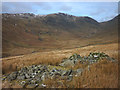
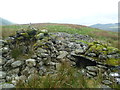
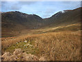
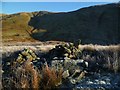
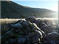
The remains of a prominent Round Cairn on north end of The Tongue, Troutbeck Park, part of a pair of cairns 1+2.
A scattered oval mound of clean stones up to 0.5m high with dimensions of 14m by 10m. Close to the cairn's centre lie two large stone slabs 1mx1.5m from the remains of a burial cist. Two modern shelters have been built on the northern end of the cairn using stones from the cairn and a slab from the cist. They face open to the north: one is like a small turret big enough to fit a shepherd and the other is a low cave, small enough to fit a shepherds dog!
You may be viewing yesterday's version of this page. To see the most up to date information please register for a free account.
")
")
")
Do not use the above information on other web sites or publications without permission of the contributor.
Nearby Images from Geograph Britain and Ireland:
©2018(licence)
©2014(licence)
©2018(licence)
©2013(licence)
©2013(licence)
The above images may not be of the site on this page, they are loaded from Geograph.
Please Submit an Image of this site or go out and take one for us!
Click here to see more info for this site
Nearby sites
Key: Red: member's photo, Blue: 3rd party photo, Yellow: other image, Green: no photo - please go there and take one, Grey: site destroyed
Download sites to:
KML (Google Earth)
GPX (GPS waypoints)
CSV (Garmin/Navman)
CSV (Excel)
To unlock full downloads you need to sign up as a Contributory Member. Otherwise downloads are limited to 50 sites.
Turn off the page maps and other distractions
Nearby sites listing. In the following links * = Image available
28m NE 54° Troutbeck Park Round Cairn 2* Round Cairn (NY4250707632)
278m ENE 64° Troutbeck Park Round Cairn 3* Round Cairn (NY4273707734)
315m NE 56° Troutbeck Park Round Cairn 4* Round Cairn (NY4274707790)
1.9km SSW 206° Hird Wood* Stone Circle (NY41630589)
2.5km NNE 23° High Street Roman Road Ancient Trackway (NY43470988)
2.5km WNW 293° The Kirkstone* Natural Stone / Erratic / Other Natural Feature (NY402086)
3.0km E 80° The Ull Stone Natural Stone / Erratic / Other Natural Feature (NY455081)
4.8km NW 325° Dovedale enclosure* Ancient Village or Settlement (NY398116)
5.6km WSW 239° The Armitt* Museum (NY376048)
5.8km WSW 254° Rydal Hall Cup Marks Rock Art (NY369061)
6.7km SW 230° Ambleside Roman Fort* Ancient Village or Settlement (NY37260339)
6.7km SSE 169° Hughill* Ancient Village or Settlement (NY4373900980)
6.8km NE 40° Castle Crag Hillfort* Hillfort (NY4692412763)
7.7km NNW 344° Beckstones Rock Art Ring Cairn (NY404150)
7.7km NNW 343° Beckstones* Rock Art (NY403150)
8.4km S 178° Bannerrigg Possible Standing Stone* Standing Stone (Menhir) (SD426992)
8.6km W 270° Grasmere Cup-Marked Rocks* Rock Art (NY33850778)
9.0km WNW 284° Mêni Arthur Natural Stone / Erratic / Other Natural Feature (NY338099)
9.1km W 269° Allan Bank Cup Marked Stone* Rock Art (NY334076)
9.7km NNW 337° St Patrick's Well (Patterdale)* Holy Well or Sacred Spring (NY388166)
10.5km NNE 33° Four Stones Cairn 3 Cairn (NY484163)
10.6km WNW 292° Dunmail Raise* Round Cairn (NY32721170)
10.7km NE 36° Four Stones Hill Standing Stones* Standing Stones (NY48951620)
10.8km NE 34° Four Stones Cairn 2 Cairn (NY486165)
10.8km N 4° St Martin’s Church (Martindale)* Sculptured Stone (NY43431840)
View more nearby sites and additional images


 We would like to know more about this location. Please feel free to add a brief description and any relevant information in your own language.
 Wir möchten mehr über diese Stätte erfahren. Bitte zögern Sie nicht, eine kurze Beschreibung und relevante Informationen in Deutsch hinzuzufügen.
 Nous aimerions en savoir encore un peu sur les lieux. S'il vous plaît n'hesitez pas à ajouter une courte description et tous les renseignements pertinents dans votre propre langue.
 Quisieramos informarnos un poco más de las lugares. No dude en añadir una breve descripción y otros datos relevantes en su propio idioma.