


<< Text Pages >> Beckstones Rock Art - Ring Cairn in England in Cumbria
Submitted by vicky on Saturday, 06 December 2003 Page Views: 6655
Neolithic and Bronze AgeSite Name: Beckstones Rock ArtCountry: England County: Cumbria Type: Ring Cairn
Nearest Town: Ambleside
Map Ref: NY404150 Landranger Map Number: 90
Latitude: 54.526760N Longitude: 2.922399W
Condition:
| 5 | Perfect |
| 4 | Almost Perfect |
| 3 | Reasonable but with some damage |
| 2 | Ruined but still recognisable as an ancient site |
| 1 | Pretty much destroyed, possibly visible as crop marks |
| 0 | No data. |
| -1 | Completely destroyed |
| 5 | Superb |
| 4 | Good |
| 3 | Ordinary |
| 2 | Not Good |
| 1 | Awful |
| 0 | No data. |
| 5 | Can be driven to, probably with disabled access |
| 4 | Short walk on a footpath |
| 3 | Requiring a bit more of a walk |
| 2 | A long walk |
| 1 | In the middle of nowhere, a nightmare to find |
| 0 | No data. |
| 5 | co-ordinates taken by GPS or official recorded co-ordinates |
| 4 | co-ordinates scaled from a detailed map |
| 3 | co-ordinates scaled from a bad map |
| 2 | co-ordinates of the nearest village |
| 1 | co-ordinates of the nearest town |
| 0 | no data |
Internal Links:
External Links:
Rock Art in Cumbria
Have you visited this site? Please add a comment below.
You may be viewing yesterday's version of this page. To see the most up to date information please register for a free account.
")
Do not use the above information on other web sites or publications without permission of the contributor.
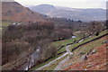
Nearby Images from Geograph Britain and Ireland:
©2020(licence)
©2017(licence)
©2012(licence)
©2010(licence)
©2012(licence)
The above images may not be of the site on this page, they are loaded from Geograph.
Please Submit an Image of this site or go out and take one for us!
Click here to see more info for this site
Nearby sites
Key: Red: member's photo, Blue: 3rd party photo, Yellow: other image, Green: no photo - please go there and take one, Grey: site destroyed
Download sites to:
KML (Google Earth)
GPX (GPS waypoints)
CSV (Garmin/Navman)
CSV (Excel)
To unlock full downloads you need to sign up as a Contributory Member. Otherwise downloads are limited to 50 sites.
Turn off the page maps and other distractions
Nearby sites listing. In the following links * = Image available
100m W 269° Beckstones* Rock Art (NY403150)
2.3km NW 314° St Patrick's Well (Patterdale)* Holy Well or Sacred Spring (NY388166)
3.4km S 189° Dovedale enclosure* Ancient Village or Settlement (NY398116)
4.5km NE 41° St Martin’s Church (Martindale)* Sculptured Stone (NY43431840)
5.5km NE 34° Hallin Fell* Cairn (NY435195)
6.0km SSE 148° High Street Roman Road Ancient Trackway (NY43470988)
6.4km S 181° The Kirkstone* Natural Stone / Erratic / Other Natural Feature (NY402086)
6.7km NE 52° Swarth Fell* Stone Circle (NY45711908)
6.9km ESE 108° Castle Crag Hillfort* Hillfort (NY4692412763)
7.6km SSE 161° Troutbeck Park Round Cairn 4* Round Cairn (NY4274707790)
7.6km SSE 161° Troutbeck Park Round Cairn 3* Round Cairn (NY4273707734)
7.7km SSE 163° Troutbeck Park Round Cairn 2* Round Cairn (NY4250707632)
7.7km SSE 164° Troutbeck Park Round Cairn 1* Round Cairn (NY4248407616)
8.1km E 80° Four Stones Cairn 3 Cairn (NY484163)
8.3km E 79° Four Stones Cairn 2 Cairn (NY486165)
8.3km SW 231° Mêni Arthur Natural Stone / Erratic / Other Natural Feature (NY338099)
8.3km WSW 246° Dunmail Raise* Round Cairn (NY32721170)
8.5km WNW 283° Brown How Ring Cairn* Ring Cairn (NY3208017008)
8.6km SE 143° The Ull Stone Natural Stone / Erratic / Other Natural Feature (NY455081)
8.6km E 81° Four Stones Hill Standing Stones* Standing Stones (NY48951620)
8.7km ENE 78° Four Stones Cairn 1 Cairn (NY490167)
8.8km E 80° Four Stones Hill Round Cairn* Round Cairn (NY4915016348)
9.2km S 172° Hird Wood* Stone Circle (NY41630589)
9.4km ENE 77° Drybarrows Stone Row/Alignment* Stone Row / Alignment (NY4962016958)
9.4km ENE 71° Towtop Kirk* Ancient Village or Settlement (NY494179)
View more nearby sites and additional images


 We would like to know more about this location. Please feel free to add a brief description and any relevant information in your own language.
 Wir möchten mehr über diese Stätte erfahren. Bitte zögern Sie nicht, eine kurze Beschreibung und relevante Informationen in Deutsch hinzuzufügen.
 Nous aimerions en savoir encore un peu sur les lieux. S'il vous plaît n'hesitez pas à ajouter une courte description et tous les renseignements pertinents dans votre propre langue.
 Quisieramos informarnos un poco más de las lugares. No dude en añadir una breve descripción y otros datos relevantes en su propio idioma.