

<< Our Photo Pages >> Cheese Well - Holy Well or Sacred Spring in Scotland in Scottish Borders
Submitted by feorag on Sunday, 25 October 2009 Page Views: 9538
Springs and Holy WellsSite Name: Cheese Well Alternative Name: Cheese Well (Minch Moor)Country: Scotland County: Scottish Borders Type: Holy Well or Sacred Spring
Nearest Town: Innerleithen Nearest Village: Traquair
Map Ref: NT35693357
Latitude: 55.591496N Longitude: 3.021953W
Condition:
| 5 | Perfect |
| 4 | Almost Perfect |
| 3 | Reasonable but with some damage |
| 2 | Ruined but still recognisable as an ancient site |
| 1 | Pretty much destroyed, possibly visible as crop marks |
| 0 | No data. |
| -1 | Completely destroyed |
| 5 | Superb |
| 4 | Good |
| 3 | Ordinary |
| 2 | Not Good |
| 1 | Awful |
| 0 | No data. |
| 5 | Can be driven to, probably with disabled access |
| 4 | Short walk on a footpath |
| 3 | Requiring a bit more of a walk |
| 2 | A long walk |
| 1 | In the middle of nowhere, a nightmare to find |
| 0 | No data. |
| 5 | co-ordinates taken by GPS or official recorded co-ordinates |
| 4 | co-ordinates scaled from a detailed map |
| 3 | co-ordinates scaled from a bad map |
| 2 | co-ordinates of the nearest village |
| 1 | co-ordinates of the nearest town |
| 0 | no data |
Internal Links:
External Links:
I have visited· I would like to visit
feorag has visited here
")
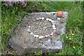
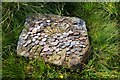
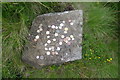
The site is marked by two stones, both naming the well and placed there in the 1960s. The setting is sympathetic, and the stones do not look modern at all.
More information about this natural, open spring can be found on Canmore ID 78380, which says: "Tradition asserts that travellers left pieces of food by the well as superstitious offerings to the 'little people' to ensure a trouble-free passage across the moor. Two inscribed stones were placed adjacent to the well by the resident of Camp Shiel in 1965. One bears the inscription 'Cheese Well' and the other 'Cheese Well', '1965' and a thistle motif."
You may be viewing yesterday's version of this page. To see the most up to date information please register for a free account.
")
")
")
Do not use the above information on other web sites or publications without permission of the contributor.
Nearby Images from Geograph Britain and Ireland:
©2018(licence)
©2013(licence)
©2016(licence)
©2012(licence)
©2017(licence)
The above images may not be of the site on this page, they are loaded from Geograph.
Please Submit an Image of this site or go out and take one for us!
Click here to see more info for this site
Nearby sites
Key: Red: member's photo, Blue: 3rd party photo, Yellow: other image, Green: no photo - please go there and take one, Grey: site destroyed
Download sites to:
KML (Google Earth)
GPX (GPS waypoints)
CSV (Garmin/Navman)
CSV (Excel)
To unlock full downloads you need to sign up as a Contributory Member. Otherwise downloads are limited to 50 sites.
Turn off the page maps and other distractions
Nearby sites listing. In the following links * = Image available
5.8km S 182° Warrior's Rest* Standing Stone (Menhir) (NT35452775)
6.0km S 183° Glebe Stone* Standing Stone (Menhir) (NT3526227603)
6.2km S 187° The Yarrow Stone* Standing Stone (Menhir) (NT3480627444)
7.8km NW 313° Cardrona* Standing Stone (Menhir) (NT30003895)
8.5km ENE 76° Caddonlee* Hillfort (NT43963551)
9.6km WSW 239° Douglas Water SE Stone Circle (NT273288)
9.6km WSW 239° Douglas Water NW* Stone Circle (NT273288)
10.0km WSW 241° Bught Rig Standing Stones (NT26852876)
10.5km SE 129° Tamlane's Well (Carterhaugh)* Holy Well or Sacred Spring (NT43742681)
11.9km ENE 65° Torwoodlee* Broch or Nuraghe (NT46553847)
12.1km NW 313° Soonhope Rock Art Rock Art (NT269419)
12.2km WNW 303° Whitestone (Peebles)* Marker Stone (NT256404)
12.3km E 93° Rink Hill (Boleside) Hillfort (NT48023270)
12.9km ESE 115° Mungo's Well (Selkirk)* Holy Well or Sacred Spring (NT47342795)
13.2km NE 51° Bow Castle Broch* Broch or Nuraghe (NT4613541717)
13.4km ESE 114° Caulks Well (Selkirk)* Holy Well or Sacred Spring (NT4789127983)
13.5km NW 318° Soonhope cairn* Chambered Cairn (NT268437)
13.6km WNW 284° Cademuir Hill* Hillfort (NT22473708)
13.9km WNW 290° Kirkton Manor* Standing Stone (Menhir) (NT22693863)
14.2km NE 43° Our Lady's Well (Borders)* Holy Well or Sacred Spring (NT45524386)
15.7km ENE 64° Hawksnest (Langshaw) Ring Cairn (NT499403)
16.6km WSW 251° Manorhead Standing Stone (Menhir) (NT19862850)
16.6km WNW 303° White Meldon* Round Cairn (NT21894284)
16.6km WNW 293° Meldon Bridge Timber Circle (NT205404)
16.8km WNW 292° Sheriff Muir Standing Stones* Standing Stones (NT20094005)
View more nearby sites and additional images


 We would like to know more about this location. Please feel free to add a brief description and any relevant information in your own language.
 Wir möchten mehr über diese Stätte erfahren. Bitte zögern Sie nicht, eine kurze Beschreibung und relevante Informationen in Deutsch hinzuzufügen.
 Nous aimerions en savoir encore un peu sur les lieux. S'il vous plaît n'hesitez pas à ajouter une courte description et tous les renseignements pertinents dans votre propre langue.
 Quisieramos informarnos un poco más de las lugares. No dude en añadir una breve descripción y otros datos relevantes en su propio idioma.