


<< Our Photo Pages >> Ackergill Mains - Standing Stone (Menhir) in Scotland in Caithness
Submitted by cosmic on Sunday, 07 October 2007 Page Views: 4493
Neolithic and Bronze AgeSite Name: Ackergill MainsCountry: Scotland County: Caithness Type: Standing Stone (Menhir)
Nearest Town: Wick
Map Ref: ND35285424
Latitude: 58.471577N Longitude: 3.111252W
Condition:
| 5 | Perfect |
| 4 | Almost Perfect |
| 3 | Reasonable but with some damage |
| 2 | Ruined but still recognisable as an ancient site |
| 1 | Pretty much destroyed, possibly visible as crop marks |
| 0 | No data. |
| -1 | Completely destroyed |
| 5 | Superb |
| 4 | Good |
| 3 | Ordinary |
| 2 | Not Good |
| 1 | Awful |
| 0 | No data. |
| 5 | Can be driven to, probably with disabled access |
| 4 | Short walk on a footpath |
| 3 | Requiring a bit more of a walk |
| 2 | A long walk |
| 1 | In the middle of nowhere, a nightmare to find |
| 0 | No data. |
| 5 | co-ordinates taken by GPS or official recorded co-ordinates |
| 4 | co-ordinates scaled from a detailed map |
| 3 | co-ordinates scaled from a bad map |
| 2 | co-ordinates of the nearest village |
| 1 | co-ordinates of the nearest town |
| 0 | no data |
Internal Links:
External Links:
")
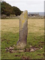
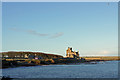
In field between Ackergill Tower and farm of the same name this stone is about 1.6m tall by 0.4m wide but very narrow.
You may be viewing yesterday's version of this page. To see the most up to date information please register for a free account.
")
")
")
Do not use the above information on other web sites or publications without permission of the contributor.
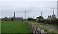
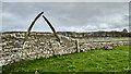
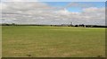
Nearby Images from Geograph Britain and Ireland:
©2008(licence)
©2011(licence)
©2021(licence)
©2010(licence)
©2019(licence)
The above images may not be of the site on this page, they are loaded from Geograph.
Please Submit an Image of this site or go out and take one for us!
Click here to see more info for this site
Nearby sites
Key: Red: member's photo, Blue: 3rd party photo, Yellow: other image, Green: no photo - please go there and take one, Grey: site destroyed
Download sites to:
KML (Google Earth)
GPX (GPS waypoints)
CSV (Garmin/Navman)
CSV (Excel)
To unlock full downloads you need to sign up as a Contributory Member. Otherwise downloads are limited to 50 sites.
Turn off the page maps and other distractions
Nearby sites listing. In the following links * = Image available
1.2km E 89° Shorelands Broch or Nuraghe (ND36475425)
2.3km S 187° Kettleburn Broch Broch or Nuraghe (ND34975191)
2.6km W 274° Norwall Broch* Broch or Nuraghe (ND32665445)
2.6km SSW 197° Fairy Hillock (Milton) Cairn (ND34465173)
3.7km SE 140° The Pap* Broch or Nuraghe (ND37625140)
3.7km NW 307° Skitten Broch or Nuraghe (ND32345655)
3.9km SE 129° Papigoe Broch or Nuraghe (ND38285176)
4.1km ESE 122° Cairn of Elsay* Broch or Nuraghe (ND38715198)
5.5km WSW 251° Thuster Broch or Nuraghe (ND30045254)
5.8km S 179° Cairn of Humster* Broch or Nuraghe (ND35294848)
6.8km N 359° Keiss Broch* Broch or Nuraghe (ND35316108)
7.0km N 0° Whitegate Broch* Broch or Nuraghe (ND35416120)
7.0km W 266° North Bilbster* Standing Stone (Menhir) (ND28295381)
7.1km S 180° Hempriggs Broch* Broch or Nuraghe (ND35114717)
7.1km SSW 197° Cairnquoy* Broch or Nuraghe (ND33094743)
7.3km N 356° Kirk Tofts* Broch or Nuraghe (ND34886151)
7.4km SSW 202° Tannach Mains* Broch or Nuraghe (ND32364748)
7.5km S 172° Hempriggs Chambered Cairn* Chambered Cairn (ND36174680)
8.5km S 189° Thrumster Little Broch* Broch or Nuraghe (ND33844583)
8.9km WNW 295° Gearsay Cairn Broch or Nuraghe (ND27265819)
9.0km WNW 287° Coghill* Broch or Nuraghe (ND26705708)
9.1km N 10° Nybster Broch* Broch or Nuraghe (ND37026314)
9.4km SSW 192° Thrumster Mains* Broch or Nuraghe (ND3319545059)
9.6km N 8° Caithness Broch Centre* Museum (ND367637)
9.6km N 8° Watenan Class I Pictish Symbol Stone (ND36806370)
View more nearby sites and additional images


 We would like to know more about this location. Please feel free to add a brief description and any relevant information in your own language.
 Wir möchten mehr über diese Stätte erfahren. Bitte zögern Sie nicht, eine kurze Beschreibung und relevante Informationen in Deutsch hinzuzufügen.
 Nous aimerions en savoir encore un peu sur les lieux. S'il vous plaît n'hesitez pas à ajouter une courte description et tous les renseignements pertinents dans votre propre langue.
 Quisieramos informarnos un poco más de las lugares. No dude en añadir una breve descripción y otros datos relevantes en su propio idioma.