 with our Megalithic Portal iPhone app")


<< Our Photo Pages >> The Roveries - Hillfort in England in Shropshire
Submitted by TimPrevett on Tuesday, 16 March 2004 Page Views: 9426
Iron Age and Later PrehistorySite Name: The RoveriesCountry: England County: Shropshire Type: Hillfort
Nearest Town: Bishops Castle Nearest Village: Lydham
Map Ref: SO325925 Landranger Map Number: 137
Latitude: 52.526173N Longitude: 2.996362W
Condition:
| 5 | Perfect |
| 4 | Almost Perfect |
| 3 | Reasonable but with some damage |
| 2 | Ruined but still recognisable as an ancient site |
| 1 | Pretty much destroyed, possibly visible as crop marks |
| 0 | No data. |
| -1 | Completely destroyed |
| 5 | Superb |
| 4 | Good |
| 3 | Ordinary |
| 2 | Not Good |
| 1 | Awful |
| 0 | No data. |
| 5 | Can be driven to, probably with disabled access |
| 4 | Short walk on a footpath |
| 3 | Requiring a bit more of a walk |
| 2 | A long walk |
| 1 | In the middle of nowhere, a nightmare to find |
| 0 | No data. |
| 5 | co-ordinates taken by GPS or official recorded co-ordinates |
| 4 | co-ordinates scaled from a detailed map |
| 3 | co-ordinates scaled from a bad map |
| 2 | co-ordinates of the nearest village |
| 1 | co-ordinates of the nearest town |
| 0 | no data |
Internal Links:
External Links:
I have visited· I would like to visit
TheWhiteRider TimPrevett have visited here
")
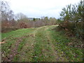
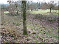
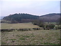
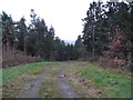
This hillfort is now concealed by trees on a low hill at Lydham, just north of Bishop's Castle.
Besides Iron Age settlement, evidence of neolithic habitation has been found here, making it one of the earliest known sites in Shropshire.
The site is on private land, and permission must be sought to visit.
Viewing the hill is possible from the immediate east, on a layby on the A488.
Have you visited this site? Please add a comment below.
You may be viewing yesterday's version of this page. To see the most up to date information please register for a free account.
")
Do not use the above information on other web sites or publications without permission of the contributor.
Nearby Images from Geograph Britain and Ireland:
©2018(licence)
©2018(licence)
©2008(licence)
©2018(licence)
©2018(licence)
The above images may not be of the site on this page, they are loaded from Geograph.
Please Submit an Image of this site or go out and take one for us!
Click here to see more info for this site
Nearby sites
Key: Red: member's photo, Blue: 3rd party photo, Yellow: other image, Green: no photo - please go there and take one, Grey: site destroyed
Download sites to:
KML (Google Earth)
GPX (GPS waypoints)
CSV (Garmin/Navman)
CSV (Excel)
To unlock full downloads you need to sign up as a Contributory Member. Otherwise downloads are limited to 50 sites.
Turn off the page maps and other distractions
Nearby sites listing. In the following links * = Image available
2.1km NNE 23° Heath Mynd Bronze Age Homestead* Misc. Earthwork (SO33369447)
3.2km NW 321° Cwm Mawr Stone Axe Factory Ancient Mine, Quarry or other Industry (SO305950)
4.0km NW 308° Roundton* Hillfort (SO29389498)
4.1km NNW 330° Corndon Hill 6* Cairn (SO30539608)
4.2km NNW 336° Corndon Hill 5* Cairn (SO30869632)
4.5km NNW 339° Corndon Hill 3* Cairn (SO30909676)
4.6km NNW 339° Corndon Hill 4* Cairn (SO30949680)
4.6km NNW 333° Corndon Hill 1* Cairn (SO30449666)
4.7km NNW 333° Corndon Hill 8* Cairn (SO304967)
4.7km NE 51° Linley Hill Camp* Misc. Earthwork (SO362954)
4.8km NNW 336° Corndon Hill 2* Cairn (SO30609693)
4.9km NNW 330° Corndon Hill 7* Cairn (SO301968)
5.4km NNW 332° New House Long Barrow* Long Barrow (SO300973)
5.4km NNW 337° The Whetstones* Stone Circle (SO30429753)
5.5km NNE 20° Ritton Castle* Hillfort (SO34449765)
5.9km NNW 340° Druid's Castle* Stone Circle (SO305981)
6.1km NNW 339° Mitchell's Fold outlier* Standing Stone (Menhir) (SO30429828)
6.2km WNW 302° Calcot Camp* Hillfort (SO273959)
6.2km NNW 340° Mitchell's Fold* Stone Circle (SO30429837)
6.3km ENE 75° Norton Stones* Misc. Earthwork (SO386940)
6.4km NNW 348° Stapeley Hill Earthworks* Misc. Earthwork (SO312988)
6.6km NNW 345° Cow Stone (Shropshire)* Standing Stone (Menhir) (SO30919888)
6.6km NNW 339° Middleton Hill Round Barrow(s) (SO302987)
6.7km NNW 349° Stapeley Hill Cairn* Cairn (SO31279904)
6.8km N 352° Giant's Grave (Shropshire)* Burial Chamber or Dolmen (SO31659925)
View more nearby sites and additional images


 We would like to know more about this location. Please feel free to add a brief description and any relevant information in your own language.
 Wir möchten mehr über diese Stätte erfahren. Bitte zögern Sie nicht, eine kurze Beschreibung und relevante Informationen in Deutsch hinzuzufügen.
 Nous aimerions en savoir encore un peu sur les lieux. S'il vous plaît n'hesitez pas à ajouter une courte description et tous les renseignements pertinents dans votre propre langue.
 Quisieramos informarnos un poco más de las lugares. No dude en añadir una breve descripción y otros datos relevantes en su propio idioma.